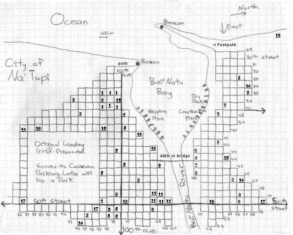
Map of constructed streets, important buildings. (most are still unfinished)
Maps of the Coastal City Na’Tupi
Drawn surfaceside (on paper!) by various crewmembers
~~~~
First Version - may contain inaccuracies?
~~~~

Map of constructed streets, important buildings. (most are still unfinished)
1: Hotel (e = entrance)~~~~
2: Garden squares (communal vegetable & herb)
3: Park square
4: Markets
5: Official buildings (street, ave intersection closest to usual entrance)
- 3rd council chambers (43rd & 100th)
- 2nd council chambers (40th & 100th)
- Immigration offices (45th & 100th )
- Port Authority Offices (45th & 105th)
- courthouse & legal center (46th & 97th)
- City Hall (49th & 100th)6: Parking lots (carts, animals)
7: Library
8: Theatre
9: Timber yard
10: Museum (and historical centre)
11: Hospital
12: Statue (unbuilt, platform only) and Plaza
13: Fish drying sheds (temporary?), packing houses
14: School (for children)
15: Training centre (for adults to learn work skills - those not already apprenticed in existing workshops)
16: Printers
17: Smithshop (mostly small parts Blacksmithing & ferriers, if inside city itself)

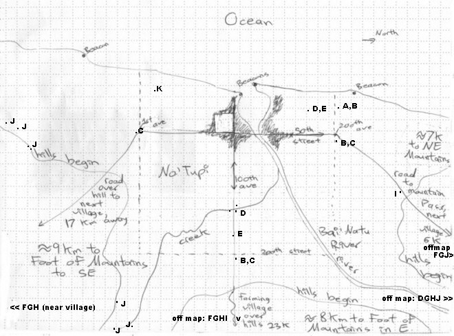
The view of the floodplain/area around city
(Dotted line shows survey marks - outline of eventual, completed city)
Legend:
Slaughterhouse ............. A
Smokehouse (meat, fish) .... B
Fish Drying sheds .......... C
Sawmills ................... D
Woodkilns .................. E
Quarries ................... F
Smithies/Smeltiers ......... G
(ore treatment facilities)
Metal ore mines ............ H
Charcoal burners ........... I
(concentrated fuel production)
Clay pits/sources .......... J
Peat harvesting locations .. K
(small fire - fuel collection)- The darkened area (with original landing grid visible) shows the buildup of stone constructs and completed, paved streets.
- Around the currently constructed locations are organised rows of tents, sod huts (see image attached to report, sketches): temporary housing for the population who have not had their permanent homes constructed (over 50% were not yet placed permanently).
- Placed among these tents and 'soddies' are outhouses (covered latrines) and waystations that provide clean drinking water and washing facilities. Beyond this, for several kilometers in all directions (apart from marsh to the South-West of city), are planted fields of crops. Both the fields and non-permanent housing are gradually being moved back, year by year, as more of the stone houses and shops are constructed.
- Along the river and coastline there is a fairly steep cliff, ranging from 2 to 12 meters above water level. Bay wall-height ranges from 10 to 4 meters, solid stone. See attached report by geology team as to local terrain - pan of arable soil above impenetrable granite, ancient flood deposits. The creek is at ground level and is the main source of fresh water for the city.
- Minimal beaches along seacoast and river's edge - river water depth depends on monthy flow (relating to snowmelt in mountains post-eclipse). Composed of grey sand and ground pebbles where beaches exist; often clogged with seaweed (which locals harvest).
- The edges of the Ocean (along the main promitory especially) and river are set aside as park space. They have paved pathways, and will not be built upon. Railings prevent small children from falling down the cliff. The edges of the bay itself are fully itilized - transportation and food commerce occurs on south side. Construction of water ships (some in drydock), repairs, etc, takes place on the north side.
~~~~
return to pictures page or
(link - return to my fanfic)
~~~~
feedback to h_raelynn@hotmail.com