|
|

|
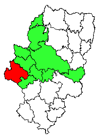
| Bijuesca is located in the province of Zaragoza, Spain |
Navarre was annexed in 1076, and during the next 100 years additional territory was added by successful wars against the Moors. In 1137 Aragón was united with Catalonia and Barcelona. Aragón grew into a leading Mediterranean naval power around the port of Barcelona. The kings of Aragón gained possession of the Balearic Islands Mallorca, Ibiza and Menorca and of Sicily, Sardinia, and Naples during the next two centuries. In 1238 the important city of Valencia was captured by Aragón from the Moors.
The marriage of Ferdinand II of Aragón (later Ferdinand V of Castilia) to Isabella I of Castilia in 1469 united those two regions. Formal merger of the two kingdoms took place on the accession of Charles I in 1516 (known as Charles V of Habsburg in Holland), but Aragón retained its own administration and representative institutions until the end of the 17th century.
With the marriage of the famous kings Isabella
and Ferdinand started the road to the unification of Spain. In their holy war - the
Reconquista - against the Moors, the Moors were conquered
(except for Granada), but they ruled the conquered states in a rather tolerant way. Many moslim
architects and craftsmen were allowed (after conversion to the Roman Catholic belief) to
continue their occupations, creating the famous mudéjar style with detailed masonry and
geometrical ceramic decorations, typical for many cultural monuments and buildings throughout
Aragón, creating the Christian Spain as we know it today.

|
| Aragón and its provincies Huesca, Zaragoza and Teruel |
The ancient settlement Salduba originally occupied the
site of present-day Zaragoza. Salduba was captured between the years 19 to 15 B.C. by the Romans, who
renamed it Caesaraugusta, in honour of its founder, the Emperor Caesar Augustus; the present name is a corruption
of the Roman name. The layout of the former Roman town has been little changed in the old part of the city,
between the rivers Coso and Ebro. In addition, the remains of the Roman walls, sewage system, theatre,
paving and magnificent mosaics are still preserved and show us the great importance this colony once had.
After the 6th century AD, the city was ruled successively by the Suevi, the Visigoths, and the Moors.
From the 12th century to the latter half of the 15th century, it was the capital of Aragón. Zaragoza
declined in importance after the unification of the kingdoms of Aragón and Castile in 1469. The city
became renowned throughout Europe, however, during the Peninsular War (1808-1814), when its citizens
displayed extreme heroism against a besieging French army in 1808 to 1809. Population (1991) 837,327.

|
| The province of Zaragoza, part of Aragón. The district of Catalayud is marked red |
