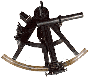

In 1735 John Hadley invented a device that let navigators tell their exact latitude
(north-south position). His creation is now called a sextant,
Latin for "sixth of a circle," a name taken from its curved shape.
To use the sextant, the navigator aims it at both the horizon and the sun
(or a star at night). Using the sextant's mirror apparatus, he aligns the
two in his sighting telescope. The scale on the rim of the sextant then
shows the altitude of the sun or star above the horizon.
The navigator can determine his latitude from this because the sun appears
lower in the sky toward the earth's poles and higher toward the equator.
To tell his longitude (east-west position), he determines the local or
sun-time, then refers to the plane's 24-hour clock, which is set to the time
in Greenwich, England. By comparing local time to Greenwich time, he can
find his distance east or west of Greenwich.
