AR 375 is comprised of two very different highways in Polk County. AR 375 West runs through some relatively flat terrain west of Mena, while AR 375 South runs through rugged mountains. AR 375, section 0 follows the original alignment of US 71 from Potter to Mena, and was originally signed north-south but is now signed east-west to eliminate the confusing situation of two AR 375's both heading south from Mena.. Section 1, signed north-south, ends at the hamlet of Shady and turns into the gravel Forest Service Road 25. Both instances of AR 375 are rather scenic, especially the southern section with many tight turns.

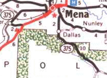
Segment of 1997 AHTD map showing both sections of AR 375.
| Section | Beginning | End | Mileage |
| 375-0 | JCT US 71 | JCT AR 8 | 8.09 |
| 375-1 | JCT AR 8 | Shady | 11.83 |
History |
AR 375 section 1 was commissioned circa 1967, starting at AR 8 just south of Mena and ending at Dallas.. The routing is unchanged from the original routing. Section 0 first shows up on the 1974 AHTD map. It originally ended at the Mena city limits, following Old US 71. In the early 80's it was extended to the intersection of Reine and Reeves in Mena, ending at AR 8. A few years later, the gravel section between Potter and Mena was paved, and several small pony truss bridges were replaced. In the late '80's, AR 8 was rerouted out of central Mena, and AR 375 was truncated to its present terminus. The eastern terminal intersection was revamped in the late 1990's to eliminate a dangerous curve.
