Arkansas 5 is a mish-mash of a highway that runs through both urban areas and remote mountains. AR 5 from its southern terminus at AR 7 north of Hot Springs to Benton, and from east of Benton to US 70B in Little Rock is a former alignment of US 70, and despite running east-west is signed north-south. AR 5 is signed along I-30's one-way frontage roads between sections 7 and 8. The Main Street Bridge over the Arkansas River between Little Rock and North Little Rock is an unsigned section of AR 5. Arkansas 5 picks back up south of Cabot, and heads into the Ozarks, serving the towns of Heber Springs, Mountain View, and Mountain Home before continuing into Missouri as MO 5.

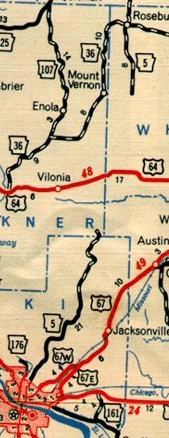
2003 Arkansas State Highway Map showing east-west section of AR 5, sections 6-9

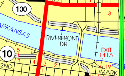
AHTD map of downtown Little Rock. Main Street Bridge (secret AR 5, section 10) is the second bridge from the left.

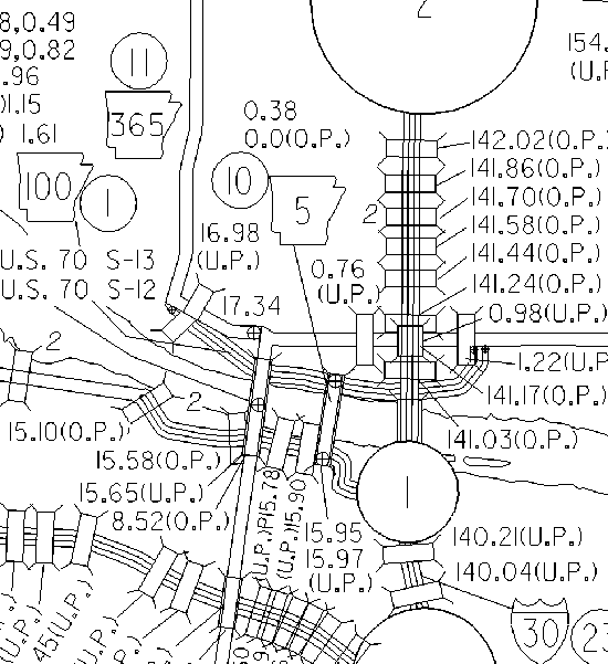
AHTD Pulaski County traffic data map showing Main Street Bridge as AR 5
| Section | Southern terminus | Northern terminus | Mileage |
| 5-6 | JCT AR 7 | Garland/Saline county line | 7.41 |
| 5-7 | Garland/Saline county line | JCT I-30 | 19.19 |
| 5-8 | JCT I-30 | Saline/Pulaski county line | 7.14 |
| 5-9 | Saline/Pulaski county line | JCT US 70B | 8.41 |
| 5-10 | JCT AR 10 | JCT AR 100 | 0.38 |
| 5-12 | JCT US 67 | Lonoke/White county line | 8.99 |
| 5-13 | Lonoke/White county line | JCT US 64 | 2.98 |
| 5-14 | JCT US 64 | White/Cleburne county line | 18.97 |
| 5-15 | White/Cleburne county line | JCT AR 25 | 7.64 |
| 5-15A | JCT AR 25 | Cleburne/Stone county line | 4.76 |
| 5-16 | Cleburne/Stone county line | Stone/Izard county line | 40.92 |
| 5-17 | Stone/Izard county line | Izard/Baxter county line | 6.47 |
| 5-18 | Izard/Baxter county line | JCT US 62B | 20.07 |
| 5-18S* | JCT AR 5 | JCT US 62B | 0.07 |
| 5-19 | JCT US 62B | Missouri line | 15.41 |
* S = Spur
History |
AR 5 originally began in North Little Rock and followed the route of modern AR 107 through much of Pulaski County before splitting off and meeting the modern AR 5 route near El Paso. It then followed today's AR 5 to Heber Springs. A northern segment of AR 5 began at AR 14 near the town of Fifty-Six. This segment of AR 5 followed modern Forest Service roads to the Calico Rock vicinity. North of Calico Rock, AR 5 originally ran on basically the modern alignment to the Missouri border.

1951 AHTD Little Rock map
Sometime in the 1940's the AR 5 designation was moved to the modern alignment between Allison and Calico Rock. By 1951, the it was removed from near the Pulaski/Faulkner county line to 8 miles south of Rosebud.

1951 AHTD map showing gap in AR 5
In 1965, AR 5 followed the modern AR 107 alignment all the way to US 64 at Vilonia. The next segment began again a few miles north of El Paso and ended at Heber Springs. The northernmost segment began about 10 miles south of Mountain View and followed the current alignment all the way to the Missouri border.
In 1959, US 70 was relocated from Hot Springs to Benton. AR 7 took over the segment west of Fountain Lake, while the segment from Fountain Lake to Benton was signed AR 5.
Around 1970 the segment from US 67/167 south of Cabot to El Paso was completed, and the old AR 5 alignment was given the AR 107 designation. By 1973, the current alignment was complete north of US 67/167. The last gravel segment of AR 5 was between AR 25 and Mountain View, and was paved in the late 1970's.
A recent change in AR 5's routing was made when the two-way frontage roads on I-30 were converted to one-way roads. AR 5 formerly followed the frontage road on the northern side of I-30, but now it "straddles" I-30.
