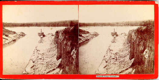
From: "The South: A tour of its battlefields and ruined cities, a journey through the desolated states, and talks with the people: being a description of the present state of the country -- its agriculture -- railroads -- business and finances." by J.T. Trowbridge, 1866, p. 201
The canal was there, -- a short deep channel connecting the river with the river again. The James here describes a long loop, seven miles in extent, doubling back upon itself, so that you may stand on its high bank, and throw a stone either into the southward-flowing or the northward-returning stream.
The canal, which cuts off these seven miles, is four hundred and eighty-six feet in length and fifty in depth from the summit of the bank. It is one hundred and twenty-two feet broad at the top, forty at the bottom, and sixty five at the high-water level. On the lower side the channel is deep enough for ships. Not so at the upper end, -- the head that was blown out having fallen back and filled up the canal. At high water, however, small vessels sometimes get through. The tide had just turned, and we found a considerable body of water pouring through the Gap.
Different accounts are given of the origin of the name of Dutch Gap. It is said that a Dutch company was once formed for digging a ship-canal at that place. But a better story is told of a Dutchman who made a bet with a Virginian, that he could beat him in a skiff-race between Richmond and City Point. The Virginia was ahead when they reached the Gap; what then was his astonishment , on arriving at City Point, to find the Dutchman there before him. The latterhad saved the roundabout seven miles by dragging his canoe across the peninsula and launching it on the other side.