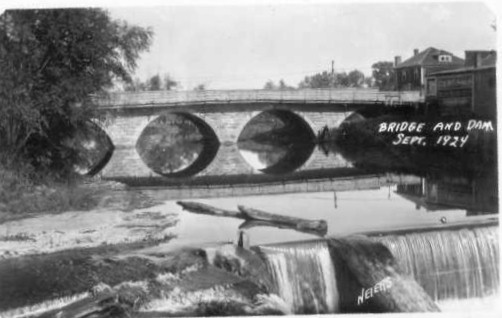

From its first sighting by a white man when James L. Langworthy explored the area in 1829, the water afforded by the North Fork of the Maquoketa River was an attraction and a focal point for subsequent activities. The first permanent setler was Nicholas Delong in 1834. By 1836, waterpower was a force in the development of the town of Cascade, named for the cascade on the river. John Sherman and Arthur Thomas built a flour mill that used the water power in 1837. As the town grew up along the river, it was incorporated in 1880. As civilization co-opted the water, the river fought back. It was reported that the average depth of the river above the falls was 12 feet before the whitemans' encroachment. In 1896, there was a destructive flood. The plat of 1906 shows the slough above the rock bridge. By 1925, much of the slough area was filled in. On June 15, 1925, there was another flash flood that damaged over 100 homes and businesses and claimed the lives of two citizens, Edward G. Bell and Mrs. Phoebe Russel. My father, Raphael P. Neiers was a photographer in Cascade and captured many of the events of that flood and subsequent events, including the removeal of the rock bridge and dam and the construction of a new bridge. The street "National St." on the plat is now US Highway 151. The bridge constructed in 1927 has since been replaced with a wider one. For a pictorial tour of the events of 1925 through 1927, click on areas of the plat map.

These are where the first pictures were taken around 11:00 a.m. on June 15, 1925. The rock bridge is just north of the dam. Kingsley's mill is on the east side of the river, beginning just south of the highway to a point downstream of the dam. Above the bridge is open farmland except for on the near east side of the river where the city power house is located. Immediately north of the rock bridge on the west side of the river is the town hall. Immediately to the south of the rock bridge on the west side is Huntington's wagon shop. Just down stream is the city park with a pavillion.
The primary flood path was down Pontiac Street. The major damage ocurred from National Street to just south of O'connell Street. Auburn is just one block south of O'Connel.
The Neiers homestead, then occupied by Nicholas Neiers was on the northeast corner of Pontiac and Auburn Streets. This vantage point was a natural for many of the early rising water pictures and later receding water pictures. immediately to the north was the Murry residence and the next house to the east on O'Connell Street was the Michael J. Neiers residence.
This is one of the two sites of major destruction. The Kurt & Gross Hardware store and Supples were two business establishments that were totally destroyed.
Link to Cascade History page and photos of downtown