The
STEVENS FamilyMetairie Cemetery

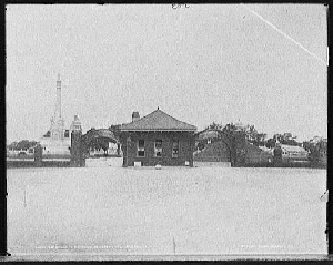
Main Gate, Metairie Cemetery, c. 1905. This gate was located on the corner of Pontchartrain Blvd and Metairie Road. The Moriarty monument is visible on the left.
Metairie Cemetery is located on a high section of ground known as the Metairie Ridge. The Ridge followed the course of Bayou Metairie, which is roughly the path of modern-day Metairie Road. Because Metairie Ridge was high ground (a rare commodity in the below-sea level metro area), in 1838 investors decided that along Bayou Metairie would make a good track for horse racing, and the Metairie Race Course was formed. As New Orleans grew in stature as a port city, the status of the race track grew as well, attracting better horses, gamblers with more money, even US Presidents. The Civil War put a damper on horse racing in the south, and the race track became a Confederate army camp. After the war, an attempt was made to revive the race track, but the sour economy of the Reconstruction help make this attempt a failure. The land was purchased in 1872 by a group of investors who formed the Metairie Cemetery Association, who decided to convert it into its current use. By 1872, the land occupied by the race track wasn't yet prime real estate, but it was close enough in to make a good location for a cemetery. With Canal St. ending nearby and its location right on the New Basin Canal, the new cemetery rapidly became a popular place for families having trouble buying space for a tomb in other cemeteries. It was like moving to the suburbs in life: you have the space to build your "dream" house, instead of settling for something much smaller in one of the "established" neighborhoods already in town. The oval shape of the race track was retained, which gave Metairie Cemetery a very unique layout. This layout has been so successful that the original plan for the cemetery is still being followed over a century later. As mentioned earlier, Metairie Cemetery was located on the west bank of the New Basin Canal, the canal that connected downtown with West End. The filled-in canal is now the site of the Pontchartrain Expressway, to which I-10 was linked in the 1960s. Visitors to New Orleans who are downtown can easily get to Metairie Cemetery by taking the Canal-Lakeshore bus line. This is one of the three Canal St. bus lines that run the length of Canal St., then branch in different directions at the foot of Canal. The Canal-Cemeteries line turns around and immediately heads back down Canal St. The Canal-Lake Vista line turns off of Canal St. onto Canal Blvd., runs down Canal Blvd., to Robert E. Lee, then heads through the Lake Vista subdivision, before returning back to Canal St. the way it came. The Canal-Lakeshore bus turns onto Metairie Road, then onto Academy Dr., going past Metairie Cemetery, then down Academy to Fleur-de-Lis, Veterans Blvd., then into the Lakeshore Subdivision via West End Blvd.
