map from "Portsmouth Historic and Picturesque", by Caleb S. Gurney, 1902
courtesy Strawbery Banke Museum
(click to enlarge)
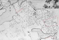
Map of Portsmouth in 1813, before the Great Fire.
Shown on this map are two Ropewalks (1740's-1830's) and the site of a Powder House (1750's-1810 ?) at the North Cemetery, Fort Anglesea by the South Mill Pond, the south Ropewalk and the State Arsenal near South Street, and the Strawbery Banke area.
The North Mill Pond Ropewalks were replaced by the Boston & Maine Railroad Station in 1840.
Fort Anglesea was built by Edward Parry around 1800, at the end of Edward St. on the banks of the South Mill Pond. It was a small wooden and stone fort with four ports, and had a brass cannon and a flag mounted upon it. It was mostly for show, as he had been harassed during the American Revolution for having Loyalist sympathies. (No known photographs)

photo by Caleb S. Gurney, courtesy Strawbery Banke Museum
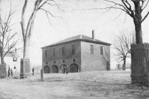
The State Arsenal near the South Mill Pond, circa 1890's. Also referred to as the "Gun House", it was built in 1808 as a one-story brick structure to house three 24-pounders and three 18-pounders on traveling cariages, as well as military supplies, for the state militia to aid the federal garrison at Fort Constitution in times of need. The second story was added after the Civil War when the arsenal was no longer needed for military purposes. The walls that enclosed the courtyard had been removed by the time this photo was taken. Demolished in 1920 after the new State Armory was completed in 1916. Site located near the intersection of Jenkin's Ct. and South School St., north of the former Haven School (1846).

The state historical marker at "The Plains".

photo by Caleb S. Gurney, courtesy Strawbery Banke Museum
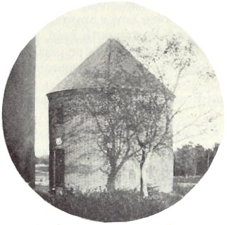
The "new" Powder House, built in 1811 at "The Plains", circa 1890's. This structure still exists on the corner of Islington Street and Essex Ave. The old powder house at the North Cemetery was deemed too dangerous by 1810 to use any longer, and was demolished soon thereafter. "The Plains" had been used as a training cantonment for the colonial and state militia from 1720-1865, replacing an earlier training field (1671-1735) at the Proprietors' Burial Ground, now part of the South Street Cemetery.

The Powder House as it appears today.

photo from "New Hampshire in the Civil War", courtesy of Bruce Heald
The 2nd N.H. Volunteer Infantry Regiment in camp, either at the "The Plains" or in Concord, sometime between April and June, 1861. Originally commanded by Col. Thomas Pierce from May to June, 1861, the regiment left their Portsmouth barracks on June 20 under the command of Col. Gilman Marston to assemble at Concord, NH with other state militia units. They participated in the Battle of Bull Run in July, 1861. The barracks at the South Mill Pond Ropewalks was known as Camp Constitution. The South Mill Pond Ropewalk was 800-feet long, and was also used as a militia barracks in 1814 during the British blockade of the harbor.
(See also Portsmouth's Ropewalks)
On New Castle Island, a stone and earthwork fort was constructed on Shaw's Hill - Clark's Point during the winter of 1775-1776, known as the Clark's Point Redoubt, or quite possibly Fort Hancock. It was a square-shaped redoubt with an open rear, with a "re-entering angle in the middle of each curtain". It was commanded by Dr. Hall Jackson. It is unknown how many guns were emplaced. It was probably not garrisoned after 1778. In 1813 the fort was rebuilt by the local militia, then known as Shaw's Hill Fort. It was never armed and never used, although several guns were held in readiness. It was abandoned after 1815, and the ruins still existed as late as 1950. Shaw's Hill is located on the northwestern arm of the island, by Riverside Cemetery.
There were several other minor shore batteries located throughout the harbor that were mentioned or shown on various old maps, mostly from the American Revolution or the War of 1812 periods. They were manned by local militia, and there are no traces left of any of them.
The Fort that never was!
In 1914 a new "fort" was proposed at the Sagamore Creek Military Reservation, on the south side of Sagamore Creek near Foye's Corner, on the western side of NH Route 1A. It was to consist of a massive concrete battery for eight 12-inch coast artillery mortars, as well as supporting garrison structures. Funds for the project never materialized from Congress, and by the mid 1930's, the project was finally scrapped. Portsmouth remained, therefore, to be one of the few major harbors never to have had modern coast artillery mortars in the defensive armament mix.
The (old) Portsmouth Armory (1914 - 1958)
(see next page for history and photos)
** List of Sources Used **
See also North American Forts: New Hampshire
and also North American Forts: Maine for additional area forts.


