Railways
 Between 1895 and 1914 more than three million people immigrated to Canada, many to the West, from all over the world. This was a reaction to a massive advertising campaign by the government of Canada, the Canadian Pacific Railway and land companies wanting to sell real estate in the north west territories of Canada. The idea was to fill the country, to encourage the subsidized railways to build, to populate the land and create a nation sea to sea.
 Many of the overseas and railroad passages were subsidized. The prospect of free land, one hundred sixty acres for ten dollars and the sweat of your brow, was irresistible to many. The government preffered homesteaders from Europe, especially the British Isles, and eastern Canada, not Americans with their own ideas about the west. On the southern prairies settlement followed the CPR, in the aspen parklands many of the settlers led the railroads by a few years.
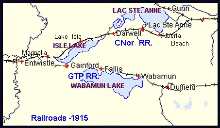
 Thus it was that in the early 1900s two rival transcontinental lines raced across the prairies west of Edmonton, sometimes almost side by side. The Grand Trunk Pacific ran south of present Highway 16 West, more or less following the Old Mill Trail, and close along the north shore of Lake Wabamun. The Canadian Northern Railway pushed its roadbeds from St. Albert, along the south shore of Lac Ste. Anne and along the north shore of Isle Lake (the Foley Trail). Both lines crossed the Pembina River on trestles less than half a mile apart just upriver from the Lobstick junction.
The construction phase of the railroads was a boom time for any local economy along the line. Men and horses were needed to move the dirt, food was needed for the camps which fed the workers, logs for the ties and lumber for all the buildings. In those days before big construction machinery the work was done by men sweating on the end of a shovel.
Clear the lines with axe and crosscut saw, fill the swamps with tree trunks, move the dirt with two or four horse slips, or ten mule team fresnos to make the grade, cut the trees to make the ties, level the bed, drop the ties and steel, spike them down and move on. Spread and tamp the gravel for ballast, drive the line to the west, to the coast, to Prince Rupert and Vancouver. Tent cities sprang up at the end of steel or by the trestles and bridges, lasted a few weeks and were gone. Build the towns and the stations and the corrals and the warehouses and the water towers and the sidings, and move on down the line.

Stony Plain, Carvel, Duffield, Wabamun, Fallis, Gainford, Entwistle, Evansburg on the GTP. Onoway, Alberta Beach, Darwell, Lake Isle, Magnolia on the CNor. Towns where no towns had existed before, bustling "communities with a future".
Of course it couldn't last, there could never be enough business to support two main lines. The two were merged beginning in 1915 and finally in 1923 the government-owned Canadian National Railway was formed with the two lines merging at Darsen Junction, west of Magnolia. The rails were ripped up from the Canadian Northern line west of Evansburg and sent to France and the roadbed became the original Jasper Highway. The northern line operated until 1936. Remains of the original roadbed can be seen very clearly two miles north of Highway 16 West on Range Road 73. With a little searching you can find the remains of the even older Edmonton, Yukon and Pacific grade just north of Duffield on Range Road 32. The CNR lines still run through Wabamun today, once more privatized, carrying bulk goods coast to coast, grain to Prince Rupert and Vancouver, cars and trucks from Japan and Korea to Eastern Canada. There are even two passenger trains a day, but they don't stop here.
Edmonton Area BRANCH LINES
PIONEERS
Trains
Movin' On

 Thus it was that in the early 1900s two rival transcontinental lines raced across the prairies west of Edmonton, sometimes almost side by side. The Grand Trunk Pacific ran south of present Highway 16 West, more or less following the Old Mill Trail, and close along the north shore of Lake Wabamun. The Canadian Northern Railway pushed its roadbeds from St. Albert, along the south shore of Lac Ste. Anne and along the north shore of Isle Lake (the Foley Trail). Both lines crossed the Pembina River on trestles less than half a mile apart just upriver from the Lobstick junction.
 Between 1895 and 1914 more than three million people immigrated to Canada, many to the West, from all over the world. This was a reaction to a massive advertising campaign by the government of Canada, the Canadian Pacific Railway and land companies wanting to sell real estate in the north west territories of Canada. The idea was to fill the country, to encourage the subsidized railways to build, to populate the land and create a nation sea to sea.
 Many of the overseas and railroad passages were subsidized. The prospect of free land, one hundred sixty acres for ten dollars and the sweat of your brow, was irresistible to many. The government preffered homesteaders from Europe, especially the British Isles, and eastern Canada, not Americans with their own ideas about the west. On the southern prairies settlement followed the CPR, in the aspen parklands many of the settlers led the railroads by a few years.