LOCATION: [MY HOME] [FUTURE] [MY OFFICE] [MY KING] [MY WEB]
Mae Hong Son Province

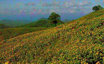
Bou Tong Field at Khun Youm District
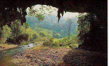

Rod Cave at Pangmapa District.

Mae Hong Son province lies next to Myanmar, cradled by the Thanon Thong Chai and the Dan Lao Mountains. It is often called the Town of Three Mists because it seems to be perennially shrouded under misty air : ground fog in the rainy season and winter, and smoke from slash-and-burn farming in the summer.
Mae Hong Son is administratively in to 6 Amphoes and 1 King Amphoe namely : Muang, Mae Sa Riang, Mae La Noi, Pai, Khun Yuam, Sop Moei and King Amphoe Pang Ma Pha. With an area of 12,681 square kilometers, Mae Hong Son can be reached from Chiang Mai either by Highway No.108 via Mae Sa Riang, for the distance of 349 kms. or Highway No.1095 via Pai which shortens the distance to some 274 kilometers.
Mae Hong Son is a province that gets an income from tourism. By its suitable geography, the location of Mae Hong Son is appropriate to organize ecotourism activities such as trekking, camping, touring the hill tribe villages, cave tour, natural study, gliding on the rubber raft, viewing birds, climbing mountain, riding elephant, floating on bamboo raft etc. The general area of Mae Hong Son is surrounded by mountain ranges and consists of 3 main rivers which are Salawin, Pai and Yuam. About 78% of the overall space of Mae Hong Son are high mountains. There is the number of Thai mountaineers around 50% which can make Mae Hong Son become an attractive place for tourists who love to go on an adventure tour and ecotourism.
Long-Necked Karen.
Long-Necked Karen
Long-Necked Karen (or Pa Dong tribe) is a hill-tribe living deep inside Myanmar boder with Thailand's Ban Nam Phiang Din. Women of this tribe wear brass rings on their necks and limbs. The number of the rings increases according to their ages. Their should blades are pressed lower and lower while their necks seem to be longer and longer.

  • Nam Hu Hai Chai, located in Tambon Phabong, ia a small pool in the cave from which the water flows out every 45 minutes and there is a breathing sound before the water flows. This is how the place derived its name, 'Nam Hu Hai Chia'. A trip on foot from Ban Hua Nam Mae Sakut takes about 3-4 hours.

  • Huai Nam Dang National Park, is about 60 kilometers along Mae Malai - Pai Highway and 6 kilometers on turning right. It commands a breathtaking view of seas of mist, flower beds and Lisu tribal people. Points of interest are Doi Chang, Doi Kiu Rom, Pong Ron Hot Spring, Namtok Mae Yen, etc.
    Huai Nam Dang is another area known for beautiful scenery especially in winter, when breathtaking views of mountains are shrounded under a sea of mist and the path along the foothills of the vantage point (Doi Kiew Lom) is covered with beautiful flowers in full bloom. If commands a breathtaking view of sea of mist, flower beds and Lisu tribal people.

  • Nam Tok Mae Surin National Park hasits area covering Amphoe Muang and Amphoe Khun Yuam. The main tourist spot 'Nam Tok Mae Surin' is located about 30 kilometers from Amphoe Khun Yuam in Ban Mae Surin. This beautiful one tired waterfall of 100 metre in height cascades down the cliff to the lower valley. For accommodation in the national park, contact the National Parks Divition, Royal Forestry Department, Tel. (02) 579-0529, 579-4842 or address to Nam Tok Mae Surin National Park, P.O. Box 16, Amphoe Muang, Mae Hong Son 58000, Thailand.

  • Wild-Sunflower Field Doi Mae U-Kho covers the area of 1,00 rais of Wild-Sunflowers, all are in full bloom between the month of November and December which make the hills and surrounding areas look like being plated with gold.

  • Nom Tok Mae U-Kho, situated at Doi Mae U - Kho, has been discovered in 1987. Just short distance before reaching Thung Bua Tong, the field of the Mexican Sunflowers, there is a branch road running for about 3 kms. to this waterfall. The on tiered waterfall, 30 meters high, flows down between the giant rocks. In the middle part of the flowing water, there is a wide rocky space where visitors can walk through to closely view the cascading water.

  • Nong Haeng Hot Spring, 25 kms. from Amphoe Khun Yuam, turn left at Km.174 for 1 kms.

  • Mae La-up Lawa Village in Tambon Huai Hom, is situated in the area where three districts meet : Mae Chaem, Mae La Noi and Mae Sariang. The culture, architecture, costumes and character of the hilltribes here are different from other hilltribes in Thailand. The attraction of this village is its hilltop location with beautiful view. Visitors can easily visit the village for it is only about 32 kilometers from the district.

  • Huai Hom Karen Village is about 4 kilometers from Ban La-up. Its villages adhere to their religion and have gentle and polite manners. As the hilltribe community development center is established in the village, the villagers have been taught to make clothes from wool and how to grow fruits and other plants of temperate climate. Therefore, this village serves as a good model for other hilltribes.

  • Mae Sam Laep is a village on Salawin river. Travel some 47 kilometers from Amphoe Mae Sariang via Highway No.1194. It is a renowned attraction among visitors for the boat trip along the Salawin river. The village is situated within a deep valley facing Myanmar with white sandy beach on some parts of the bank. Visitors can put up their tents in the area of Salawin National Park Office, 30 minuites by boat from Mae Sam Laep to the north. Accommodation is also avialable in Sop Moei which can be reached by taking a 30 minute-boat-ride from Mae Sam Laep to the south.

  • Rafting Along Pai River
    With its approximately lenght of 180 kms., 30 m. width and 7 m. depth, the Pai River is the biggest and longest river in Mae Hong Son. This challenges the adventure lovers to raft along this river. There most suitable points are recommended. There are :
    Source of the River to Amphoe Pai : Starting from Huai Chang Kaeo, 16 kms. from Amphoe Pai to Wiang Nua Bridge or Ban Chomphon near Amphoe Pai, taking about 6 hours.
    From Amphoe Pai to Amphoe Muang : Starting from Ban Mo Paeng, 3 kms. from Amphoe Pai to Amphoe Ban Pang Mu in Amphoe Muang. The distance of this route is about 70 kms. and takes at least 5 days of rafting, and due to must difference in water level at one point of the Pai River along this route, therefore, two rafts setting are required to change at this mentioned point. More information of rafting along this route can be obtained from official at Pai District Office.
    From Amphoe Muang to Thai-Myanmar Border : Starting from Ban Huai Dua, Tambon Pha Bong, about 6 kms. from Amphoe Muang, to the border at Ban Nam Phiang Din. Normally this section of the Pai River is more enjoyable to cruise along by long-tailed motor boat which only takes 2-3 hours returned trip of trekking on elephant back instead of rafting since the nature and scenery both side is fascinating and beautiful.
    Most suitable time to raft is between October and March, and 2 weeks prior contact for the raft is recommended. Contract for rafting, boat cruise, accommodation and trekking through Mae Hong Son Resort, Tel. (053) 611406, or Rim Nam Klang Doi Resort, Tel. (053) 612142 or travel agents in Mae Hong Son.

    Festival and Celebrations in Mae Hong Son
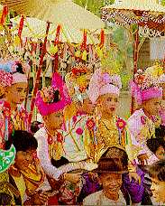
  • Poi Sang Long Precession
    help
    Poi Sang Long Precession

    This is the celebration of novice ordination with the Thai Yai tribe people hold to be a highly meritorous occasion. Offerings for monks are carried through the town in a gala procession. It is usually held during March and May before the Buddhist Rain Retreat period.


    Return to the previous page

    Information
    : Tourism Authority of Thailand Tourist Service Center
    : TAT Northern Office : Region 1,
    105/1 Chiang Mai-Lamphun Rd., Amphoe Muang, Chiang Mai 50000
    Tel.: (66 53) 248-604, 248-607, 241-466; Fax: (66 53) 248-605
    E-mail : tatcnx@samart.co.th
    Area of Responsibility : Chiang Mai, Lamphun, Lumpang and Mae Hong Son
    : Hotel & Resorts in Mae Hong Son


    1 1