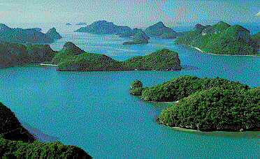
Ang Tong Archipelago National Park, Surat Thani


|
Among the 14 Southern provinces, Surat Thani ranks first in area, occupying over 12,800 square kilometres of flat and fertile land south of Chumphon and
Ranong, with the Provinces of Nakhon Si Thammarat and Krabi bordering it to the south, and the Province of Phanga to the west.
The Gulf of Thailand lies to the east, where the major and the most significant river, Tapee, flows out to the sea, forming the largest breeding ground of marine life in the country.
The Tapee River is the lifeline of the city, forming the main feature of the province, and also the livelihood of the people. It starts from Khaoyai, a high mounain in Thungyai District of Nakhon Si Thammarat and flows out to the sea at
Ban Don Bay, with many tributaries and feeder canals, making the land on both sides rich and fertile, and the lifestyle of the people fascinating. Surat Thani is the city of canals, comparable to Amsterdam in the Netherlands.
The area at the mouth of the river is murky, with silts and fine sand, surrounded by mangrove forest, making up an ideal breeding ground for oyster, prawn, and othe marine products.
Oyster farms are comfortably sited in the area, involving minimum capital investment and no technology. With proper wooden pens submerged in the water for a period of time, oysters are ready for the market. Ban Don or
Surat oysters are famous, fetching rewarding income for those making their homes in the many fishing villages along the waterways in the Province.
|


