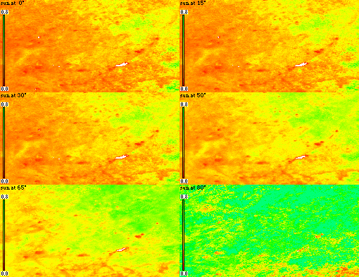

The BRDF model used obeys the reciprocity principal : the positions of sun and sensor may be exchanged. This means that the "sun" angle shown above may also be interpreted as the viewing angle. So, what you are looking at can be likened to viewing a sparse grassland from the ground (at about 1.4 metres above the ground in my case) and then increasing the viewing angle until it is pretty much what you would see from the air. If you have ever flown over these grasslands (or any similar surface) you may well have noticed that what you thought was a green field appears increasingly brown from the 'plane. This is a "BRDF effect"! In this case, the process governing the phenomenon is a result of either a decreasing proportion of soil in your field of view or decreasing illumination of soil (more shadows cast onto the soil surface) as the view / sun zenith increases; reciprocity means that the results can be interpreted in either way.
The scene is for an area bounded by 112 - 116 degrees E by 42 - 45 degrees N. An NDVI scale from zero to 0.8 is shown on the left and the white area just right of centre is Qagan Nur lake. The western part of the scene is dominated by desert steppe; this changes through a transition zone (ecotone) to typical steppe in the east. The high NDVI area in the east and on the same latitude as the lake is lush A. chinense steppe reserved for haymaking. The very low NDVI areas appearing orange or red throughout the series are areas with saline soil (salt pans).
Note that as the solar zenith angle increases, NDVI is significantly higher for a larger proportion of the modelled scene; this is what we would expect as a result of reduced illumination and increased shadowing of soil background and increased illumination of vegetation protruding above a fairly level surface.
It should be borne in mind that the stability of the model inversion (and
therefore its ability to model reflectance) is partly dependent on the angular
distribution of the AVHRR observations used in model inversion, in this case 17
NOAA-14 PM scenes and 4 NOAA-12 scenes. A quantitative measure of the noise
introduced in modelling to different geometries is provided by the weight of
determination; see
this page. For these modelled NDVI scenes, the
weight of determination exceeds 1 when the solar zenith angle exceeds 70 degrees;
there is therefore significant noise in the scenes modelled to solar zeniths of 75
and 80 degrees.