BRDF Applications in Semiarid Grassland Monitoring with the AVHRRs
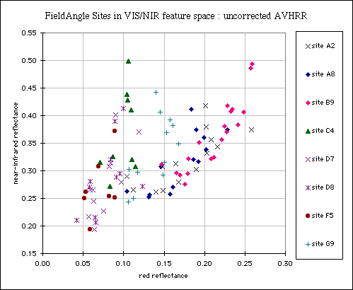
Impact of BRDF on AVHRR Channel 1 and 2 reflectance :
Low Separability
Afforded by 21 Orbits of AVHRR LAC/HRPT Uncorrected for BRDF Effects
(acquired over a
17-day period).

Atmospherically-corrected AVHRR VIS and NIR reflectances
from grassland field survey sites in Xilingol Aimag, Inner Mongolia
P.R.C.
The scatterplot above shows atmospherically-corrected reflectances from the
ground resolution elements closest to field survey sites from 21 orbits
acquired during the period 3rd to 19th August 1996 (four LAC scenes from
NOAA-12 downloaded from the NOAA
Satellite Active Archive and 17 HRPT
scenes from NOAA-14, acquired at the
Institute for
Remote Sensing Applications in Beijing). The sites are called
"FieldAngle" to distinguish them from the sites where
nadir-view radiometry was carried out.
For off-nadir radiometry (data not shown here), 4-channel a Milton radiometer
was used atop a 4 metre mast which was tilted from 40 degrees in the
backscattering direction to 40 degrees in the forward-scattering direction,
close to the principal plane (the plane made by the target, the sensor and the
sun) in
this way.
Sampling Sites
The sites are coded as :
- Site A2: Stipa gobica desert steppe
- Site A8: Stipa gobica desert steppe with
Stipa krylovii
- Site B9: Caragana microphylla desert
steppe
- Site C4: Artemisia frigida Wild. typical
steppe
- Site D7: Stipa grandis typical steppe
(fair-to-middling)
- Site D8: Stipa grandis typical steppe (lush)
- Site F5: Aneurolipideum chinense typical
steppe
- Site G9: Neopallasia pectinata steppe
(degraded S.krylovii typical steppe).
Their locations can be seen on this
map.
More detailed information on the grassland types is
here.
Click on the "Site XX" links to see photographs of the sites.
Use Back button | Index |
Disclaimer

