 | ||||||
| Articles | Projects | Resume | Cartoons | Windsurfing | Paintings | Album |
Land Use at Clover Point, B.C.
Waterose et. al.
Index:
Section 1. Introduction:
Inventories of terrain and geomorphology, ecology, and socio-economic aspects are required to appropriately guide human activities and developments. Terrain and biophysical inventories are also necessary to understand the underlying processes that control terrain and biotic distributions over space and time.Clover Point is located on southern Vancouver Island, just west of Ross Bay. This peninsula was formed by glacial deposition. Since the retreat of the Wisconsinian Glacier it has been covered with a layer of soil and vegetation (Pipkin, 1994). The dominant rock types are variable; wark gneiss and metamorphosed basalts indicate volcanic activity in the geological past (Weston, 1986). Traces of granodiorite and sandstone are evident as well.
This coastal area is densley populated. Anthrogenic disturbance to the shoreline began with the construction of the original seawall in 1911 to retard shoreline erosion (Emmett,1995). Subsequent artifical measures include the construction of an artificial reef in the bay, forty meters offshore from the base shore cliff, and reconstruction of the seawall (Thuringer, 1995). Exotic vegetation has been introduced to the point to stabilize the cliffs.
Clover Point has unique and diverse characteristics that have both intrinsic value and anthropogenic value.
Section 2. Geomorphology and Terrain:
The two terrain sections that were examined included a coastal shoreline section and an exposed incline slope section of a small cliff.
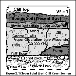
The shrubs and grasses on the cliff help to provide additional stability to the slope and minimize landslides. The cross section of the slope is illustrated in Figure 2.1 (Image Reference: Burke, 1997).  The inclined slope consisted of three main layers: the upper horizon layer, the fluvial deposition layer, and the coarse till mix layer. The top layer contained organic soil which is called humus and the ah soil horizon. The depth of this layer was approximately 4.0 meters. The second layer contained a mixture of sand, silt, and, many small rounded pebbles. The depth of this layer was approximately 1.0 meters. The third layer contained sand, silt, and, large stones. This layer extended from the second layer to the base of the cliff. The slump at the base of the cliff is the result of erosion and overload.
The shot rock at the base of the cliff provides a solid base for the pedestrial path to the pebble beach and functions as an erosion prevention barrier. The coastal beach is comprised mostly of well rounded pebbles. The round shape is caused by the displacement of the pebbles from the waves. The waves create a rounding of the pebble by constant rolling action created from the displacement.
Section 3. Biophysical:
The vegetation on top of the bluffs at Clover Point consisted mainly of grass, Scotch Broom, and some low lying shrubs. There were many seagulls and pigeons in the area that probably feed on garbage and aquatic organisms. Although the cliffs around Clover Point provide potential habitat for birds, no nests were observed in the cliffs. Two species of seaweed were observed on the beach, one of which was identified as Bull Kelp. A Bull Kelp forest was also visible offshore where it is anchored onto the artificial reef west of Clover Point. Bull kelp forests provide a rich habitat for enhanced marine biodiversity.A beach seine was taken on the southeast side of Clover Point. The aquatic life captured included: invertebrates such as the Moon jellyfish, nudibranch, Staghorn sculpin; vertebrates such as juvenile Coho Salmon and Herring; and, several species of seaweed.
Section 4. Land Use:
4.1 Overview of Land Use:
Clover point is a natural headland on bedrock that has been human enhanced; it has a paved parking lot surface and grass park with a concrete ramp down to the shore. It is a multiple land-use area. The range of anthropogenic uses includes commercial, residential, recreational, and a sewage treatment facility. Coastal zone management mitigates potential conflicts of interests between the wide range of different land-uses.
4.2 Coastal Development:
The Clover Point area is primarily single unit residential housing north of Dallas Road. There are some multiple family residential building blocks in single family units that have been converted, and there are low three story apartment buildings. There are many commercial bed and breakfast units on Dallas Road. The south side of Dallas Road is recreational land that is used by cyclists, joggers, kite fliers, dog walkers, handicapped persons, skateboarders, hangliders, tourists, windsurfers, beach-combers and bird watchers. On the south side of the point, there is a large concrete parking lot, a concrete boat ramp, a boat storage shed, and the sewage pump station. The pump station is concealed under a grassy hill with access via tall doors to the east side of the point. The south side park is planted with grass to the edge of a steep cliff which is approximately 15 meters in height. The base of the cliff is accessible by concrete stairs, and a seawall ramp.The seawall around Clover Point was built in 1911 (Emmett,1995) to protect the shoreline. The seawalls, west and east of the Clover Point, were constructed by different methods. The seawall west is less enhanced and is comprised of a gravel bed laid down on top of shot rock. The seawall east was significantly enhanced prior to 1995 by the construction of concrete steps from the beach level up to the seawall level. The concrete steps vibrated when they dissipated the incoming wave energy. Consequently, the concrete step seawall east was further enhanced by the addition of smaller clast pebbles and gravel to dissipate wave energy and reduce the slapping impact of the incoming wave energy.
Further east of the concrete step seawall the beach access south of Dallas Road is restricted to privately owned residential houses. There is very little public beach access for the area east of Ross Bay. Public beach access west of Clover Point extends along Beacon Hill Park which is public parkland.
4.3 Values and Conflicts:
The public and private interests of the Clover Point land area create multiple uses of the area. These create conflicts of interest based on different points of view. A summary of these conflicts include: multiple recreational consumer users; residential housing versus commercial tourism; natural environment versus enhanced environment; development versus parkland; anthropogenic land use versus natural habitat use; and, cost effective sewage disposal versus harm to the environment.The Clover Point sewage pump house processes 7-8 million gallons per day of raw sewage from local municipalities (Foley, 1997). This primary treatment facility removes the solids and discharges the fluids 1.5 miles south of the coast into the ocean. In addition, there are three cross-connected short distance outfalls that discharge raw sewage into Ross Bay from the local area. The issue conflict regarding the issue of dumping deleterious substances into the ocean versus the cost of developing a more effective method of sewage treatment. This issue was put before the public in 1992; 56% of the public voted to maintain the existing level of sewage treatment rather than construct new treatment facilities (CRD, 1994). This example is only one of the many multiple land use conflicts that exist at Clover Point.
4.4 Governance:
The issue of sewage treatment triggered the formation of the Capital Regional District (CRD) in 1966 (CRD, 1994). The CRD is primarily concerned with how to handle the growing problem of the amount of sewage and the quantity of contaminants in the sewage. The proposed solution incorporates a command and control approach to limiting quantities of sewage discharged from source and targeting specific points of discharge which are identified as deleterious. There are jurisdictional issues between local municipalities and other levels of government. The efforts of governments working together to achieve target goals is an effective approach to coastal zone management.
Section 5. References:
Written for Royal Roads University ES307 Coastal Zone Management SeriesBurke, J. 1997. Original Graphic. Sooke, B.C.
CRD Engineering Department. 1994. Liquid waste management in the CRD.
Foley, George, Senior Operator, CRD. 1997. Personal Interview
Emmett, B. and P. Thuringer. 1995. An Assessment of Fisheries Resource and Habitat Issues Related to the Reconstruction of the Ross Bay Seawall. Unpublished Report for the Office of the City Engineer, City of Victoria.
Pipkin, Bernard W. 1994. Geology and the Environment. West Publishing Company, Minnesota.
Thuringer, P. And Y. Carolsfeld. 1995. Assessment of the Colonization of the Artificial Reef off the Dallas Road Cliffs. Unpublished Report for the Office of the City Engineer, City of Victoria.
Weston, Jim & David Sterling. 1986. The Naturalistís Guide to the Victoria Region. Morriss Printing Company, Victoria.
Waterose et. al.
Judith R. Burke
and: S. Ivanko, R. Luco, J. Walker, S. Wilmot

 email Waterose
Please Sign My Guestbook
Please View My Guestbook

| Articles | Projects | Resume | Cartoons | Windsurfing | Paintings | Album |
 | ||||||