Long valley about 7000', Owens valley, topped by Round valley, about 4000'.
57.69 miles, 820 vertical feet, maximum speed 35Big map
Another cold clear morning. On the road by 8 as usual. Took the Crowley lake alternative to highway 395. Less traffic and prettier than 395, but not as nice as the June lake loop. 7000' Sherwin summit, just south of Toms Place (sic), begins a descent mared 8 miles, 6%. Since the bottom is at about 4500', I believe it. We decided to stay on 395 for the descent, rather than fight the twists and turns of what we figured would be a steep Rock Creek road alternative. Enough headwind to control our speed without much braking.
It’s hot at 4000'! Thermometer in Bishop said 91° at noon. At 6 PM, it said 96°. Stopped at tourist info office, went to Brown’s campground a mile south of town. Pitched tent and lightened bikes, then rode back to town.
We each had a bowl of chili for lunch. Too much meat, too few beans; left us tired and lazy. Nevertheless, we rode four miles east on highway 6 to the Laws railroad museum. Hot, dry, no strength. Good tailwind, though, and a very slight downgrade on the way out.
The museum was okay, not outstanding. No pictures. One locomotive, a 4-6-0 oil burner in need of paint. Turntable overgrown with weeds. Displays of doctor’s office, general store, etc. Interesting to see a horse-drawn hearse, painted black and draped in black, complete with a wicker casket inside. An old house had been moved there. Rail depot in good shape. Lots of junk machinery around, some of which we understood – for example, the stamping mill.
High point was a big bell, maybe 30" diameter, mounted at shoulder height. I swung it back and forth a few times – finally got an unexpectedly loud bong! Startled me. Didn’t continue – once was enough.
Back to Bishop. Dozed, loafed. Stopped at ranger station to inquire about the bristlecone pine forest. Then stopped at a bike shop for a second opinion (more knowledgeable?) on road quality and grade.
Lots of color in the mountains. Reminds me of Death Valley. Desert vegetation, few trees, no grass. Drinking lots of water. It evaporates so fast, you don’t realize you’re sweating.
Back to camp for showers. A lazy day. Wandered back to town in late afternoon. Ate at Whiskey Creek: potato skins, chicken pot pie, Anchor porter on draught. Good!
Writing this at our campsite, where we were just visited by a Danish bicycle tourist who’s also staying here. He’s on his way from Seattle to LA by way of Santa Barbara. Mountain bike, no toe clips. Very young, very serious, very clean-cut, wouldn’t be surprised if he’s a soldier at home. Said his record is 97 miles in one day. He came past Lassen and Tahoe on his way down, plans to ride to the bristlecone pine forest tomorrow, and Mt Whitney in a couple of days.
I just realized why the campground is exactly one mile from town, and why Laws was exactly four miles from Bishop – in the flat country of the valley here, the roads are on the standard American survey grid. In the kind of country that attracts bicycle tourists, this is rare indeed.
63.02 miles, 6430 vertical feet, maximum speed 39 mph
Private campground last night much nicer than government ones. For example, white painted walls in restrooms, no graffiti, and clean. Even thought we might avoid noisy neighbors, but not completely.
After we turned in, we heard a coyote howling. Loren thought there were two, serenading each other.
Broke camp and did our obligatory 14 miles of forward progress to Big Pine in 45 minutes before breakfast. The Dane was leaving the restaurant as we arrived.
The idea was to spend most of the day climbing to the bristlecone pine forest in the White mountains. Since we knew it would be a difficult day, we decided to stay in a motel rather than camp. Checked at Big Pine motel, lucked into a room, not cleaned up yet, but with previous tenants already gone.
Stripped excess weight off the bikes. We were duly forewarned: there is no water available on this ride, so we filled all the water bottles before we left.
11:30 AM, Cedar Flat entrance station
On the road to the bristlecone pine forest before 9.
Big Pine is about 4000' above sea level. Agreed to rendezvous at the 6500' entrance station, but after the first 1000' of climb, I decided we should rendezvous every thousand vertical feet. It wasn’t obvious that we’d even make it all the way to the entrance station. Started too late to beat the heat!
Batchelder spring is at 6000', our second rendezvous. It’s said to be the site of an old Westgard pass toll house. Sign says water unsafe for drinking. Filled an already emptied water bottle from spring, added an iodine tablet – for emergency only.
It’s slowly becoming a little cooler as we climb.
Above the spring is a section called The Narrows, and they are. The road squeezes down between high vertical walls.
Several sources told us the entrance station was at 6500' – but nothing there! Could I have missed it? Could there be a hump, and a descent to 6500'? Finally found the place at 7360'! Altimeter error is one thing, but this is ridiculous – we were well above the CalTrans 7000' road sign!
Easier grade above 6000' and definitely cooler. No doubt about making it now.
Height
is less of a problem
than heat!
12:10, Piñon picnic area
Road climbs to 7800', descends to 7640. Picnic area is at 7720.
Lots of trees, spread wide apart. Not much vegetation between trees. Cedar, piñon. Tree where I’m sitting to write this has light blue berries: juniper.
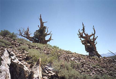
Whole mountain seems to be stratified broken rock, slate or hard shale. Sometimes the ground is sandy, but there’s almost no soil anywhere. Even under the plants, there’s very little mulch of fallen leaves. Life is so difficult here that the plants can’t afford to shed debris. Earth varies between tan, gray, deep purple. Nice wildflowers, but sparse.
View at 7800' crest includes Palisade glaciers across the valley on the Sierra peaks. From the Owens valley, these just look like patches of snow. Seen from above, they are clearly valleys filled with ice and snow. Slow glacial creep down the grades is easy to imagine.
3:30, Piñon picnic area again
Loren stayed at Piñon to rest or hike or maybe ride further. I went on alone.
Climb got really difficult. I switched my computer to display cadence. It was as low as 70 once, frequently in low 80s. Some knee pain. Couldn’t spin faster and remain ærobic.
Crest into bristlecone pine forest just above 10,000' is actually a wide almost flat meadow – not grass, but low scrub brush. Got there about 15 minutes behind the Danish tourist, who said he had rested half an hour at the campground. The chipmunk bandits came out, easily half a dozen of them. Visitor center had a hummingbird feeder, but there were no takers while I was watching.
At 2 o’clock, went to a ranger talk. Wonderful speaker. He said that in real life he’s a high school principal, does this in July and August, the only time it’s warm enough to be open (today was 68°, windy).
Lots of fascinating info on bristlecone pines. Walked Discovery trail after the talk.

The antiquity of bristlecone pines was only discovered in 1953 by a ranger who (quite legally) cut some down for paneling, noticed the density of the rings, and called in Dr Edmund Schulman, of the University of Arizona, who was searching for the oldest living organisms in the world, and had been looking at giant sequoias.
Many living bristlecones are over 4000 years old. (Interesting how you get different info from different sources. Guy at tourist info in Bishop said they had found living bristlecones as old as 7000 years.)
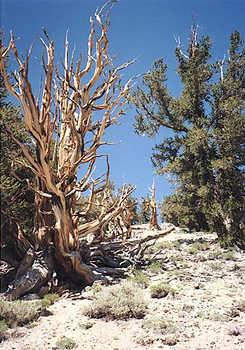
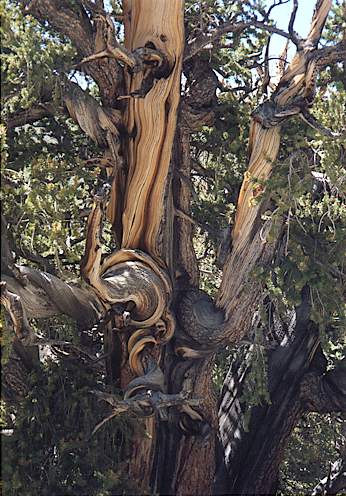
Ordinary pine needles last three years; bristlecone needles last 30 years. There were very few needles fallen beneath the trees.

Mostly the soil is bare white broken rock, dolomite, which provides the very alkaline environment that the trees like. The bristlecone forest ends abruptly when the white dolomite ends. The cones take three years to develop; in the fourth year, they burst and release their seeds. Third-year cones are purple. On the north-facing slopes, there’s more water, and it stays around longer; thus there are more organisms to attack living trees and decay the dead ones. The oldest trees are found on the south-facing slopes. Dead wood on south-facing slopes doesn’t decay; it just gradually erodes. |
The same species in more benign environments (eg Patriarch grove further north on the same mountain) grows to 36' girth, but the big ones grow fast and don’t live as long.
Some of the living trees are over 4000 years old; by overlapping ring patterns with deadwood, science has constructed a climatological history as far back as 10,000 years. They think they won’t be able to go much further back, because the last ice age ended about 10,000 years ago. While the White mountains were not glaciated as were the Sierra, the ground was frozen, so there would have been no trees.

Measuring the presence of carbon-14 has long been a well-established archæological tool for dating organic material, and a lot of history is based on its results. But the method originally assumed a constant atmospheric density of C14 throughout the eons.
By comparing C14 concentration with the countable age of bristlecone pine wood, this assumption was proven to be incorrect. This has had radical implications on history. For example, archæologists no longer believe that civilization began in the Tigris-Euphrates valley and spread slowly from there. Rather, it appears to have sprung up all across Europe almost simultaneously. This certainly makes sense to me – consider the origin and spread of the industrial revolution, viewed through a lens with a resolution of decades or perhaps centuries.
Told ranger the bristlecone pine forest was a high point for me. He said he thought 10,100' might be the highest paved road in California. Probably true – the Yosemite people claim it’s Tioga pass, but that’s only 9945'.
Headed down. Stopped at Sierra lookout point, 9800'. Clearly basin and range country to the south and east. Stopped at Piñon picnic area to see if Loren was still here – no. It’s even hot at this altitude by now.
6 PM, Big Pine
Hot, windy descent. Drank the last of the safe water at Piñon, came down dry. Not desperate enough to tap the emergency bottle. Maybe not dehydrated as much as I thought – had to pee when I got back. Used sunscreen twice today, but still got burned.
Later, in Big Pine…
Loren is a lot more cautious on downhills than I am. He started down an hour before I did, but said he had only been back at the motel about fifteen minutes before I showed up. Probably wise of him.
Walked out for film and a quart of OJ. Not much in this town.
River in Big Pine runs north! Startled me until I checked the map – it’s merely Big Pine creek heading northeasterly to join up with the southward-flowing Owens river.
Sign posted in Big Pine laundromat: local public transit agency bus schedule to Bishop, the big town. One run to Bishop Wednesday AM, returning to Big Pine Wednesday PM. That was it.
Waitress at restaurant this evening didn’t know whether they had any dark beers. “Which ones are dark?” she asked. “I wouldn’t know, because I don’t drink beer.” After looking over the selection, I should have said, “I can see why!” But of course, I didn’t think of it until a minute too late.
Cal Tech radio telescope dishes at base of White mountains. Map shows UC observatory at top, further north than we went. Astronomers at next table in restaurant tonight, talking about globular clusters and such. They were just beginning their day!
Interesting to watch the Germans at yet the next table over, trying to order a Budweiser. The waitress didn’t understand their pronunciation at all, and they had to figure out how to pronounce it in English before she got it.
Steak was what the restaurant had, so steak was what we had. As usual, baked potato saved the meal. Loren wasn’t worried that he wouldn’t finish his peanut butter and ice cream pie with chocolate sauce – he was afraid he would!
More…