Rules and Guidelines
Rule
Submitting your finished elevation:
If at all possible: upload your greyscale image to a web server.
Send me an email saying what the filename is.
I will get it and post it on the my Quilt pages.
This is the Most reliable way to send pictures.
You may have to convert your elevation from a pict to a gif (this is ok), or post it as a .pict, it just might not be visible. If you can see your elevation as a greyscale image on a web page, then I can get it.
If you don't have a place to upload images, email me.
Guidelines
Deadlines
Please try to get your elevation done quickly, within a week or two.Size and Resolution
Make your elevation with the DEFAULT resolution, which is 128x128. I have to render all the elevations together on one machine, after all. I will make all the terrains of the island the same size, the default from the create menu.Altitude
The water level will be a little above the bottom of the terrains, so make sure you account for a bit of underwater parts in any beaches you make. Figure on about 5% of the bottom being under water.Scale and Theme
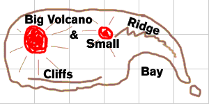
I made a sketch of an island map based upon what little discussion we had about the form of the island.Basically, 2 volcanos in the middle (west and east of middle), a ridge descending to rocks at the southeast, a bay at the south, and clffs to the southwest.
This is only a suggestion, but I think it is good to have a common goal to work towards, so here's one possibility, below. (feel free to stray from it.)
As far as scale goes, well let's just say it's a 2 volcano island, and houses would be mere specks.

Materials
I will choose/make one material to apply to all the terrains. It will be 3 layered: sandy beaches, green slopes, and rocky peaks. Feel free to send me suggestions. Then I will put a water around the Island, and some clouds in the sky. Likewise, any suggestions are welcome.Finishing Touches
As this is just a terrain-joining exercise (and a large scale island), there won't be any buildings, boats, or similar constructs. However, we can add a few things such as low level clouds below the peak, a small lake, outcroppings, or large caves, for example. Anything like this would be when the terrain elevations are done, and not too involved, sort of like the cherry on top, if anyone is so inclined.Go back to Quilt #1 Page
upload - manage