Tuesday, June 20, 2000
Texas Military Campgrounds
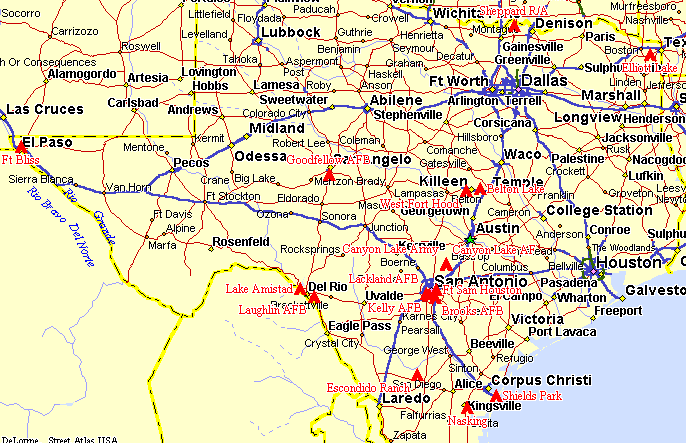
Military Campgrounds in Texas
 State Map Street Atlas 7 Map (Zipped)
 Belton Lake Recreation Area (TX1R)
 Brooks Fam-Camp (TX3A)
 Canyon Lake Air Force Recreation Area (TX17A)
 Canyon Lake Army Recreation Area (TX4R)
 Elliott Lake Recreation Area (TX5R)
 Escondido Ranch(TX14N)
 Fort Bliss RV Park (TX2R)
 Ft Sam Houston(TX15R)
 Goodfellow AFB Recreation Camp (TX6A)
 Kelly Fam-Camp (TX7A)
 Lackland Fam-Camp (TX8A)
 Lake Amistad Recreation Area (TX9A)
 Laughlin Fam-Camp (TX10A)
 Nasking (NAS Kingsville)(TX16N)
 Sheppard AFB Recreation Annex (TX11A)
 Shields Park NAS Recreation Area (TX12N)
 West Fort Hood Travel Camp (TX13R)
Belton Lake Recreation Area (TX1R)
Updated: Tuesday, June 20, 2000
 Area Map
 Street Atlas 7 Map (Zipped)
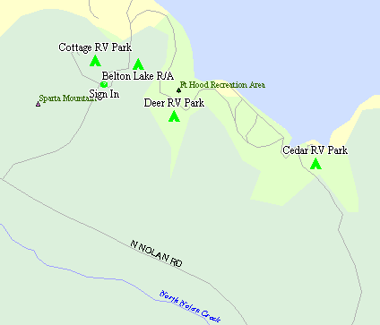
 Campground Map
Directions: From I-35, take US-190 West to Loop 121 (less than a mile) North.
Follow Loop 121 North past one stop sign to a traffic light where there is a
large school on the Northwest side.  Turn left (West) at this light on
Sparta Rd and follow this road 6 miles, you will cross a cattle guard
entering Ft. Hood.  Turn right on Cottage Rd at the BLORA sign.

Telephone: (254)287-2523
Season: All year
Reservations: Not accepted
|
Type of site
|
Spaces
|
Hook-ups
|
Daily
|
Weekly
|
Monthly
|
|
Hardstand
|
11
|
W/S/E
|
$15.00/11.25(GA) |
$? |
$275.00/$300.00 |
|
Hardstand
|
48
|
W/E
|
$12.00/$9.00(GA) |
$? |
$225.00/$250.00 |
|
Tent Spaces
|
22
|
W/E
|
$? |
$? |
$? |
|
Tent Spaces
|
60
|
None
|
$? |
$? |
$? |
Notes: Golden Age Passport (GA) accepted for free entrance to Recreation Area and
25% discount on camping.
Monthly rates are Winter Season (10/1 - 3/31)/Summer Season (4/1 - 9/30)
Camped here two weeks in June of 1996 but lake was
very low due to drought. Some very nice RV sites. Fishing is available at many
small lakes on Ft. Hood with Texas license and $10.00 permit available at the
Rod & Gun Club on the fort.
Input from members: Earlier this month I camped at the Belton Lake Recreation area in Texas
(TX07R3). This is an excellent camp, but your directions need updating.
The directions should read "Take US-190 West to Loop 121 North. Follow
Loop 121 North, and after crossing the railroad overpass, turn left (West)
on Sparta Road. Drive past the Sparta Elementary School, continue across
the cattle guard, go another six miles and turn right (North) on Cottage
Road". The name is officially
Belton Lake Outdoor Recreation Area, hence the acronym "BLORA". This
information may be verified by calling the director at 254 287 3722.
M/Sgt William L Tribble USAFR Ret.
Denton, Tx 940 387 8879
March 27, 2000
Return to State Map
Fort Bliss RV Park (TX2R)
Updated: Tuesday, June 20, 2000
 Street Atlas 7 Map (Zipped)
 Picture of Camp
Telephone: (915)568-4693
Season: All year.
Reservations: Not accepted


Ft. Bliss Web Page
|
Type of site
|
Spaces
|
Hook-ups
|
Daily
|
Weekly
|
Monthly
|
|
Concrete
|
73
|
W/S/E
|
$12.00 |
$? |
$? |
|
Tent Grass
|
8
|
None
|
$4.00 |
$? |
$? |
Notes: Pull thrus, level concrete pads, BBQ Grills, 8'x10' Patios, Picnic
Tables. 24 hour laundry facilities, kitchenette in family room, RV storage
available. Office hours, Bldg 4130 on-site, 0800 - 1600. Checkout time is
1300. Stays limited to 14 days except special circumstances.
Return to State Map
Brooks Fam-Camp (TX3A)
Updated: Tuesday, June 20, 2000
 Area Map
 Street Atlas 7 Map (Zipped)
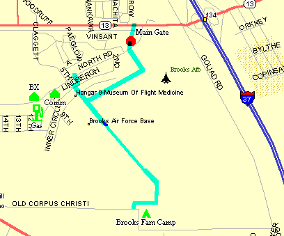
 Campground Map
Telephone: (210)536-1844
Season: All year
Reservations: Not accepted
|
Type of site
|
Spaces
|
Hook-ups
|
Daily
|
Weekly
|
Monthly
|
|
Hardstand
|
7
|
W/S/E
|
$10.00 |
$? |
$? |
|
Hardstand
|
8
|
W/E
|
$8.00 |
$? |
$? |
|
Tent/Camper
|
Open
|
None
|
$3.00 |
$? |
$? |
Member Input: If you get to San Antonio, try Brooks AFB. It's 15 miles from most
things, but a real nice place to relax, also at $8 for water and electric
or $10 for full hook up. It's less than a mile from US281 to the front
gate.
rlaubham@juno.com
June 13, 2000
Return to State Map
Army Canyon Lake Recreation Area (TX4R)
Updated: Tuesday, June 20, 2000
 Area Map
 Street Atlas 7 Map (Zipped)
 Picture of Camp
 Web Page
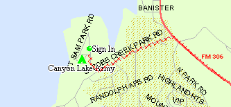
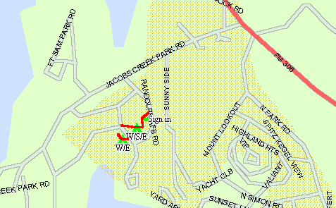
Directions: Exit I-35 at Exit 191 and travel North on FM-306 approx. 16 miles
and through the town of Canyon City.  Turn left onto Jacobs Creek Rd. for
0.6 miles.  Turn right into Recreation Area.
Telephone: (888)882-9878
Season: All year
Reservations: Not accepted
|
Type of site
|
Spaces
|
Hook-ups
|
Daily
|
Weekly
|
Monthly
|
|
Blacktop
|
32
|
W/E
|
$10.00 |
$? |
$? |
|
Tent Spaces
|
Open
|
None
|
$8.00 |
$? |
$? |
Facilities: Swimming beach, marina, fishing, dump station, propane sales, concrete patios,
picnic tables, grills, shady sites, small store on site.
Notes: $4.00 per day entry fee in addition to camping fee. Golden Age Passport good for free
entry to area but no discount on camping.
Return to State Map
Elliott Lake Recreation Area (TX5R)
Updated: Tuesday, June 20, 2000
 Area Map
 Street Atlas 7 Map (Zipped)
Directions: Exit I-30 at Exit 206 ad go South on SR-86 to US-82 outside of Main
Gate.  Turn left onto US-82 and go to East Gate for entry.  ID required as base stickers
are not recognized. Through East Gate to Texas St. (1st left ) and turn left. Follow Texas St.
approx. 2 blocks, then turn right onto Avenue K.  Follow Avenue K South
as it joins E. Boundary Patrol Rd. for approx. 4 miles to a Y in the road.
Turn left at the Y and follow this road approx 3 miles to campground on
the left side.  Go to second road into camp ground and turn left to office
to register.


Telephone: (903)334-2254
Season: All year
Reservations: Not accepted
|
Type of site
|
Spaces
|
Hook-ups
|
Daily
|
Weekly
|
Monthly
|
|
Gravel
|
16
|
W/S/E
|
$10.00 |
$50.00 |
$? |
|
Gravel
|
16
|
W/E
|
$7.00 |
$35.00 |
$? |
|
Tent Gravel
|
20
|
None
|
$2.00 |
$? |
$? |
Notes: $2.00 camping discount with Golden Age Passport. No Commissary or
Gas Station on post. Check-in is in camping area.
Back Gate Hours: Weekdays: 0530 - 0645 & 1500 - 1800
Weekends: 0700 - 0800 & 1600 - 1700
From members: E-mail conncetion available at campground office. No time limit on camping and contractor employees are occupying prime sites full time. One has been camped here for over 4 years.
Return to State Map
Goodfellow AFB Recreation Camp (TX6A)
Updated: Tuesday, June 20, 2000
 Street Atlas 7 Map (Zipped)
 Campground Map
Telephone: (915)944-1012
Season: All year Thu - Mon
Reservations: Not accepted
|
Type of site
|
Spaces
|
Hook-ups
|
Daily
|
Weekly
|
Monthly
|
|
Camper Spaces
|
19 |
W/S/E
|
$10.00 |
$? |
$? |
|
Tent Spaces
|
Unlimited
|
None
|
$3.00 |
$? |
$? |
Notes: Unlimited strays.
Return to State Map
Kelly Fam-Camp (TX7A)
Updated: Tuesday, June 20, 2000
 Area Map
 Street Atlas 7 Map (Zipped)
Directions: Exit I-35 at Exit 153 or I-10 at Exit 572 onto US-90 West.
Follow US-90 West approx. 2.4 miles and exit onto Cupples Rd.  Follow Cupples
Rd. as it becomes Quintana Rd. for approx. 1.8 miles and turn left into East
Kelly Gate at a traffic light.  Ask for directions.  Camp is nearby.


Telephone: (210)925-5725
Season: All year
Reservations: Not accepted
|
Type of site
|
Spaces
|
Hook-ups
|
Daily
|
Weekly
|
Monthly
|
|
Paved
|
30
|
W/S/E
|
$12.00 |
$?.00 |
$?.00 |
|
Tent Grass
|
Many
|
None
|
$3.00 |
$? |
$? |
Notes: 30 day limit. Scheduled to close in 2001.
Return to State Map
Lackland Fam-Camp (TX8A)
Updated: Tuesday, June 20, 2000
 Area Map
 Street Atlas 7 Map (Zipped)
 Campground Map
Directions: Exit I-35 at Exit 153 or I-10 at Exit 572 onto US-90 West.
Follow US-90 West approx. 7.2 miles and exit onto SR-13 (W Military Dr.).
Follow SR-13 South approx 0.75 miles to Luke Blvd and turn left to East
Main Gate.  Follow Luke Blvd Approx. 0.7 miles to Foster Ave. and turn
left onto Foster.  Camp and sign in will be on your right at Foster and
Ladd St.


Telephone: (210)671-3106
Season: All year
Reservations: Not accepted
|
Type of site
|
Spaces
|
Hook-ups
|
Daily
|
Weekly
|
Monthly
|
|
Asphalt
|
29
|
W/S/E/CTV
|
$12.00 |
$? |
$? |
Notes: Free laundry. Modem friendly at Telephone Center.
Return to State Map
Lake Amistad Recreation Area (TX9A)
Updated: Tuesday, June 20, 2000
 Area Map
 Street Atlas 7 Map (Zipped)
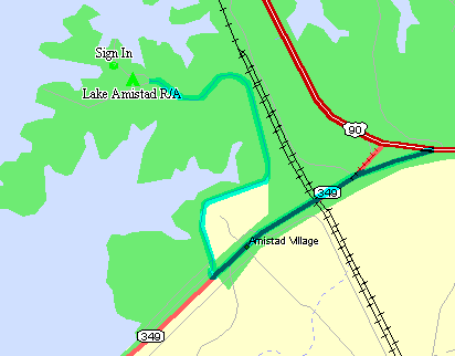
Directions: From Del Rio Texas, take US 90 north for about 10 miles to the
road to the dam (Spur 349).  Follow road toward the dam and turn right onto
the first road past the dam headquarters.  Rec. Area is 1.5 miles on this
blacktop road.


Telephone: (210)775-5971
Season: All year
Reservations: Accepted
|
Type of site
|
Spaces
|
Hook-ups
|
Daily
|
Weekly
|
Monthly
|
|
Concrete
|
5
|
W/E
|
$8.00 |
$? |
$? |
Notes: Nice concrete pads with covered picnic tables. Dump station is
just across the street from the RV pads. Reservations accepted from
retirees 30 days in advance, active duty 60 days in advance. Walking
distance to marina/boat docks. About 21 miles from Laughlin AFB.
Return to State Map
Laughlin Fam-Camp (TX10A)
Updated: Tuesday, June 20, 2000
 Area Map
 Street Atlas 7 Map (Zipped)
Directions:  Enter base main gate from US 90 about 6 miles east of Del Rio
 Texas.  Follow street straight ahead to Famcamp.  Winter check-in is at Host
site 16 in Famcamp.  Summer check-in is at Fiesta Center, first building on
left side past the gas station as you come from the main gate toward the
Famcamp.


Telephone: (210)298-5474
Season: All year
Reservations: Not accepted
|
Type of site
|
Spaces
|
Hook-ups
|
Daily
|
Weekly
|
Monthly
|
|
Camper Spaces
|
15
|
W/S/E/CTV
|
$10.00 |
$65.00 |
$225.00 |
Notes: All sites are nice level pull through concrete pads. Little or no
shade. Good place from which to visit Mexico. Small BX and Commissary are
nearby on base. Pets must be on leash. Check out time is 1200. No shower
facilities.
Return to State Map
Sheppard AFB Recreation Annex (TX11A)
Updated: Tuesday, June 20, 2000
 Area Map
 Street Atlas 7 Map (Zipped)
 Picture of Camp
Telephone: (903)523-4613
Season: All year
Reservations: Accepted
|
Type of site
|
Spaces
|
Hook-ups
|
Daily
|
Weekly
|
Monthly
|
|
Gravel
|
8
|
W/S/E
|
$10.00 |
$? |
$? |
|
Gravel
|
16
|
W/E
|
$8.00 |
$? |
$? |
|
Tent Spaces
|
Many
|
None
|
Free |
$? |
$? |
Member Input: When you turn north on Sheppard Rd., the entrance is approximately 1/2 mile.The campground is approximately 2000 acres, so some say, and includes a 2,500 ft grass runway just south of the camping areas. I have been there when small planes come land. The campground is well maintained and managed.
John Dittbrenner
August 10, 2000
Return to State Map
Shields Park NAS Recreation Area (TX12N)
Updated: Tuesday, June 20, 2000
 Area Map
 Street Atlas 7 Map (Zipped)
 Campground Map
 Picture of Camp
Directions: Follow the South Padre Island Drive (Hwy 358) south from I-37 and stay on Hwy 385
when it leaves the S.P.I.D. just before crossing the bay to Padre Island. This goes through the
gate to the N.A.S. Stay on this street to the second stop sign and turn right on Ocean Drive.
This will take you right into the RV Camp.


Telephone: (361)961-1293/1294/1295
Season: All year
Reservations: Actve duty only
|
Type of site
|
Spaces
|
Hook-ups
|
Daily
|
Weekly
|
Monthly
|
|
Gravel
|
12
|
W/S/E
|
$10.00/$11.00/$12.00 |
$? |
$? |
|
Gravel
|
24
|
W/E
|
$7.00/$8.00/$9.00 |
$? |
$? |
|
Tent Space
|
5
|
W
|
$3.00/$4.00/5.00 |
$? |
$? |
Notes: Rates are: Active Duty/Retired/Civilian.
Return to State Map
West Fort Hood Travel Camp (TX13R)
Updated: Tuesday, June 20, 2000
 Area Map
 Street Atlas 7 Map (Zipped)
Directions: From I-35, take US-190 West past Ft. Hood entrance. From US-190 take the
West Fort Hood exit.  Turn left at the stop sign onto Clarke Road, go 1/2
mile to the entrance on the right.

Telephone: (254)288-9926
Season: All year
Reservations: Accepted
|
Type of site
|
Spaces
|
Hook-ups
|
Daily
|
Weekly
|
Monthly
|
|
Hardstand
|
64
|
W/S/E/CTV
|
$9.50 |
$62.50 |
$267.00 |
|
Tent Spaces
|
20
|
None
|
$2.00 |
$? |
$? |
Notes: Golden Age Passport accepted for 25% reduction of camping fee.
Nearest town is Copperas Cove, just West of West Ft. Hood Rd. on US-190.
Very narrow RV sites on blacktop and gravel. Dump Site, Covered picnic tables,
Playground, Free Local phone service, Laundromat.
Member Input: Mail may be delivered to General Delivery, Copperas Cove, TX
There is no phone hookup for a computer modem there, but e-mail may be
sent and received at the post library or the Cyber Cafe in the Arts &
Crafts Center.
Sixty day time limit may be renewed every sixty days almost
indefinitely. There are some folks living there in lieu of base
housing.
Rod Corona
June 30, 2000
Return to State Map
Escondido Ranch(TX14N)
Updated: Tuesday, June 20, 2000
 Street Atlas 7 Map (Zipped)
Directions: Located in the Southwest corner of McMullen County Texas, 25 mile
outside of Freer, Tx.  Take US 59 and SH44 South from Freer.  3.2 miles
south of Freer turn right of the SH44 West towards Enicanal.  Travel 8.5
miles until you see Duval county road 401.  Turn right on Duval cr401.
Travel down 401 for 13.7 miles, this road dead ends at the ranch. There
is only one fork in this road, stay on the right.
Telephone: (830)373-4419
Season: All year
Reservations: Accepted
|
Type of site
|
Spaces
|
Hook-ups
|
Daily
|
Weekly
|
Monthly
|
|
Camper Spaces
|
12
|
W/S/E
|
$10.00 |
$? |
$? |
All of our trailer recepticles are 50 Amp, so please bring your own
adaptor.
Notes: We do have a limited dds in our lodge for our customers.
Currently there is no length of stay time limit.
Reservations must be made in advance, so not to disappoint someone
by not having any slots open.
Active duty military 5 weeks in advance
Retired and reserve military 4 weeks in advance
DOD employees and Navy League 3 weeks in advance
Note: Dependents making reservations fall under the times of their
sponsor.
Return to State Map
Ft. Sam Houston(TX15R)
Updated: Tuesday, June 20, 2000
 Area Map
 Street Atlas 7 Map (Zipped)
 Picture of Camp
Directions:  From Austin
- Take IH 35 South to Exit 161 (Binz-Engleman Road).  Take first possible
right (Petroleum/WW White Road) which is right before the the TX National Guard
Armory.  Proceed approximately 2 miles and we are located on the left hand
side of the road.  Gates are open from 0600-2300 each day.
From Downtown San Antonio - Take IH 35 North to the Rittiman Road Exit.  Take the
turn-around and continue up the access road.  Turn right on Petroleum/WW
White Road which is right before the TX National Guard Armory.  Proceed
approximately 2 miles and look for us on the left.  Gates are open from
0600-2300 each day.
Telephone: (210) 221-5502
Season: All year
Reservations: Accepted
|
Type of site
|
Spaces
|
Hook-ups
|
Daily
|
Weekly
|
Monthly
|
|
Pull Through
|
50
|
W/S/E
|
$14.00 |
$? |
$? |
|
Tent
|
25
|
None
|
$8.00 |
$? |
$? |
Member Input:From: BUCK3620@aol.com
To: donlogan@bigfoot.com
Sent: Monday, January 03, 2000 1:48 PM
Subject: Directions to Ft Sam Houston Travel Camp
The directions should read: turn right on Holbrook just before the National Guard Armory, go 1/2
mile, travel camp is on left. Note: after you go thru the gate into the Army Post, the road is
WW White
Notes: Each RV site includes water, electric (30 amp and 50 amp), and sewage. A picnic table,
grill, and lantern post are also located at each site.
Each tent site includes picnic table, grill, lantern post and water nearby.
Covered Patio $15.00/Day
Amenities: Camp Store, Coin operated laundry facilities, Air conditioned bathrooms w/showers,
Children's playground, RV Dump Station with potable water for refilling water storage tanks.
Return to State Map
Nasking (TX16N)
Updated: Tuesday, June 20, 2000
 Area Map
 Street Atlas 7 Map (Zipped)
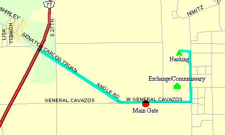
Directions: On Base. Travel South on Hwy 77 into Kingsville, exit to the left on Carlos Truan
Blvd. or General Cavasoz and proceed approx. 1 mile to security gate (have proof of insurance,
drivers license, and vehicle registration) where directions to park will be provided


Telephone: (512)516-6443
Season: All year
Reservations: Accepted
|
Type of site
|
Spaces
|
Hook-ups
|
Daily
|
Weekly
|
Monthly
|
|
Camper Spaces
|
8
|
W/E
|
$8.00 |
$? |
$? |
|
Camper Spaces
|
10
|
W
|
$5.00 |
$? |
$? |
Return to State Map
Air Force Canyon Lake Recreation Area (TX17A)
Updated: Tuesday, June 20, 2000
 Area Map
 Street Atlas 7 Map (Zipped)
Directions: Exit I-35 at Exit 191 and travel North on FM-306 approx. 16 miles
and through the town of Canyon City.  Turn left onto Jacobs Creek Rd. for
0.5 miles.  Turn left into Recreation Area.
Telephone: ?
Season: All year
Reservations: ?
|
Type of site
|
Spaces
|
Hook-ups
|
Daily
|
Weekly
|
Monthly
|
|
Concrete
|
9
|
W/S/E
|
$15.00 |
$? |
$? |
|
Blacktop
|
9
|
W/E
|
$10.00 |
$? |
$? |
Facilities: Picnic tables, marina, fishing pier, beach.
Notes: $3.00 entry fee waived for campers. W/E sites only good for small RV's and are very
small sites.
Return to State Map

Return to State Index

 Return to SMART Home Page


 Belton Lake Recreation Area (TX1R)
 Canyon Lake Air Force Recreation Area (TX17A)
 Canyon Lake Army Recreation Area (TX4R)
 Elliott Lake Recreation Area (TX5R)
 Goodfellow AFB Recreation Camp (TX6A)
 Lake Amistad Recreation Area (TX9A)
 Nasking (NAS Kingsville)(TX16N)
 Sheppard AFB Recreation Annex (TX11A)
 Shields Park NAS Recreation Area (TX12N)
 West Fort Hood Travel Camp (TX13R)
 Campground Map
 Campground Map

 Campground Map

 Campground Map


 Campground Map




 Return to SMART Home Page
