How To Make Your Own Plotting Sheets
1. Get a piece of paper with a dimension of about 18 x 22 inches.
2. Draw three Latitude lines horizontally 3+3/4 inches apart. This will give you 60 minutes of arc with each measuring 1/16 of an inch. (60 x 1/16 inch = 3+3/4 inches).
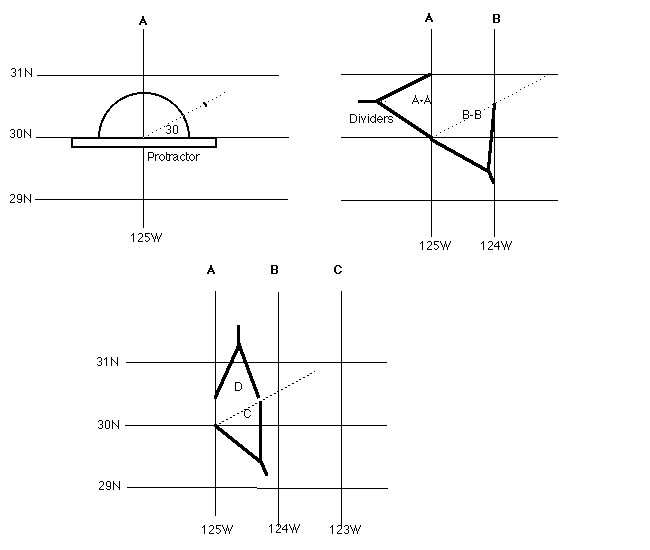
3. Draw the first meridian as show in A (see illustrations below). Lay your protractor as shown and mark the angle specified by your middle Latitude. In this case the middle Lat. is 30 degree.
4. Mark an angle of 30 degrees and draw a dotted line lightly. If the middle Lat. is 25 degree, mark 25 degree.
5. Using a pair of dividers measure a distance of 3+3/4 inches along the dotted angle line and mark it.
6. Draw the second meridian (or third etc.) intersecting the point you just marked, as shown at meridian B. Distance A-A = B-B = 3+3/4 inches. All other required degrees of Longitude on the same chart are plotted the same horizontal distance apart between meridians A and B. The standard 1/16 inch is also used to measure the minutes of Longitude. However these are first measured on the ruler (vertically between the Latitude lines) and then plotted along the dotted angle line as shown at C. The measurement (of minutes of Longitude) at D can now be carried anywhere.
The distance between the Latitude lines always remain the same. Whereas as your Latitude get higher, the distance between Longitude lines will get closer.
You can also construct these plotting sheets in the metric scale. Just make sure that the distance between the Latitude lines are easily divided into 60 equal measurements for each minutes of arc. For example: 12 cm between Lat. line will give you 1 minute of arc every 2 mm.

Return to CruiseWeb
HomePage or Piloting
and Navigation Page