

BANGLADESH
GEOGRAPHY, NATURE & WILD LIFE
![]()
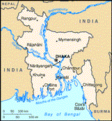
Bangladesh is a country in South Asia, nestled in between the Bay of Bengal and the Himalayas; surrounded mostly by India, shares a border in the south-east with Mayanmar and fronts onto the Bay of Bengal. The country is flat, and dominated by the braided strands of the Ganges-Brahmaputra-Meghna delta, the largest delta in the world. Bangladesh is known as the land of rivers, with 290 rivers criss-crossing the country. Where Bangladesh end and the sea begins, there is a murky zone of shifting sediments, watercourses, floodwaters and silt. Over 90% of the country are composed of alluvial plains less than 10m above sea level, making it an inviting proposition to flood-prone rivers and tidal waves. The only relief from these low-lying plains occurs in the northeast and southeast corners where modest hills rise to an average height of around 240m and 600m respectively. Rivers do cause devastating floods but the sediments they bring down from the Himalayas create wonders for Bangladesh. These sediments form a lush evergreen landscape, which is the envy of many a country. Behind the images of cyclones and floods is a strikingly lush and beautiful land with a rich history and a variety of attractions unusual for a country this size.
Roughly two-thirds of Bangladesh is fertile arable land and a little over 10% remains forested. The country is home to the Royal Bengal Tiger, leopards, Asiatic Elephants (mostly migratory herds from Bihar), and a few remaining black bears. There are also plenty of monkeys, langurs, gibbons (the only ape on the subcontinent), otters and mongooses. Reptiles include the sea tortoise, mud turtle, river tortoise, pythons, crocodiles, gharials and a variety of snakes. There are more than 600 species of birds: the best known is the mynah but the most spectacular are the kingfishers, fishing eagles, parrots and cockatoos.
The climate of Bangladesh is subtropical and tropical with temperatures ranging from an average daytime low of 21 degrees Celsius in the cold season to a top of 35 degrees in the hot season. Bangladesh has three main seasons: the monsoon or `wet' season from late May to early October; the 'cold' season from mid-October to the end of February; and the `hot' season from mid-March to mid-May. There is also a 'cyclone season' - May to June and October to November.
Full country name: The People's Republic of
Bangladesh
Location: Across the tropic of cancer Bangladesh lies in the northeastern part of
South Asia and extends between 20° 34' and 26° 38' North Latitude and 88° 01' and 92°
41' East Longitude. The country is surrounded by India on the West, the North and the
northeast and Mayanmar on the Southeast and the Bay of Bengal on the South.
Area: 147,570 sq km
Land Area: 133,910 sq km
Land boundaries: Total 4,246 km - Burma 193 km, India 4,053 km.
Coastline: 580 km.
Maritime claims:
Contiguous zone 18nm
Exclusive economic zone 200nm.
Territorial sea 12nm.
Population: 125 million
Capital city: Dhaka (pop: 7.4 million)
People: 98% Bengali, 1% Bihari, 1% tribal
Language: Bangla (Bengali)
Religion: 87% Islam, 12% Hindu, 0.5% Buddhist & 0.3% Christian
GDP: US$151 billion
GDP per head: US$290
Annual growth: 4.5%
Inflation: 8%
Links to Web Sites on Bangladesh
http://www.cyberbangladesh.org/
![]()
To create this web page various sources were used. In many cases the sources had different figures for the same topic. If any of the information given seems dubious, the reader is requested to inform me, and if possible to provide the accurate information. Any kind of suggestions and advice will be highly appreciated. Please mail me at