or
"The Universe is out to get me!"

"Been in the Storm So Long"
or
"The Universe is out to get me!"

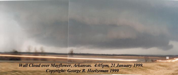
Wall cloud over Mayflower, Arkansas. 4:05pm, Jan. 21, 1999. The rotation is about one mile away and produced an F2 tornado within about 45 minutes of this photo
We knew something was coming for at least a week. MOS models were indicating a cold front
punching into warm, moist air with several days of sun preceding. Really, though, I'd not thought much of it initially
since a stronger system looked to be moving in the following week and, besides, we had an AMS/NWA meeting the night
of the 21 and I was looking forward to winning the weather station door prize.
Ironic, isn't it.
When 20 Jan rolled around, SPC began indicating a rare HIGH RISK! We
get these in Arkansas about once a year. Everything was beginning to shape up for a major outbreak. On Thursday
21 January I made sure I had my equipment at school. Camera, batteries, maps, and of course the mighty NOAA were
at the ready. As the day wore on, southerly winds increased and the temps rapidly climbed into the low 70's.
Bizarre for January, even in Arkansas.
The day had "that feel" to it as well. Students were hyper as cattle just before a thunderstorm - but
then so was I. During my off period the NOAA wailed in proclamation of a TORNADO WATCH until 9:00pm. This was
followed almost immediately by the first of many severe thunderstorm warnings. Thus, at 2:10, the outbreak had
begun.
Struggling to contain myself during my last class of the day, the NOAA went off four more times. It did not disappoint
the students, either. Indeed, one of these warnings announced the first tornado of the day in central Arkansas.
A storm announced earlier near Hot Springs had turned tornadic and was moving toward the Ferndale (west Pulaski
Co.) Area.
Now, I was about to come out of my skin.
FINALLY the bell rang and I was off the lot before most of the students could escape the building. Initially heading
toward the Benton area, I quickly realized that the real action was further north toward Morgan and Conway. Stopping
at Stagecoach Road, I examined the map and listened to current warnings and storm positions. Realizing that one
tornadic cell was due over the Mayflower area at 4:05pm I decided to turn around and head back north.
That is when I discovered first hand why Arkansas has so many killer tornadoes.
Between Morgan/Maumelle and Mayflower on I-40 is a large rice field. This field affords an excellent westerly
view and it at this field that I intended to observe the passing of the aforementioned tornadic storm. Side roads
in this area are either non-existent, cut through hilly wooded terrain, or would pose a challenge even to the Mighty
Jeep (yes, just like in Twister). The Interstate was the best option for observing and escape. As I approached
the Morgan/Maumelle exit I could already see the huge wall cloud beyond the hills - I was also stuck in traffic.
Capping the last hill before the rice field, I cleared the trees and gazed upon a wall cloud which was clearly
rotating and ready to drop a tornado at any minute (it actually waited about 45 minutes, fortunately). Which gets
us back to why Arkansas has so many killer tornadoes.
People are too foolish to get out of the way.
With the wall cloud bearing down, and an obvious RFD and rain/hail curtain circulating around the bear's cage,
traffic came almost to a complete stop. Pulling out into the median, I quickly took a few photos, getting the
first hint of camera problems to come. After finishing one roll and reloading, I watched as the rotation passed
over the freeway and proceeded NE toward the uninhabited domain of Camp Robinson.
U-turning in the median, I quickly proceeded back toward Morgan - only to develop engine problems. Theorizing
that some gas treatment was in order, I directed the stuttering and stalling Jeep into the Morgan Texaco and tanked
up.
At which point the NOAA wailed yet again.
Another tornado warning was issued, this time for Pulaski County. The tornado in question had been spotted 11
miles SW of Maumelle and was moving NE at about 45mph - which meant I was directly in its path. Since no sirens
were sounding, and everyone was proceeding about their business, I felt that I at least owed it to the attendant's
common humanity to at least suggest taking cover. This having been done I rushed back to the Mighty Jeep (even
remembering the gas cap) and took off toward downtown Maumelle - still with no sirens.
As I headed south on Maumelle Blvd., I could see the core bearing down from the west and the rain free base to
the SE. There was one location in Maumelle which would afford the ideal observation point - my only concern was
how close to rotation I would wind up, especially since I was now pretty clearly in the clear slot and inside the
cage. An 60 acre field lay just to the east of the large 40 acre Lake Willenstein. Scott
Blair and myself had used a bank on the edge of this field as shelter on a chase in 1998. I did not,
however, expect what I saw when I arrived at this location.
On the approach, I could see the wall cloud was near the field. As I came into position it moved (slowly it seemed)
over the south edge of the field. Still, there were no sirens, and still, people went about their business, even
driving DIRECTLY UNDER THE AREA OF ROTATION!!! Six other spotters were
on the ground just north of the rotation and I pulled in behind them and began snapping away.
Now, those of you who are experienced will immediately say "You FOOL! Are you not sitting in the clear slot?
Are you not about to get slammed by the RFD?" To that, I say "YES" but it was the only safe location
under the circumstances. This wall cloud was magnificent. The mid-level wrapping was dramatic, the clouds the
classic sickly green, and the enormous tail cloud (which local news broadcasts kept calling a funnel) was so low
one could almost touch it (more on that later).
As I watched, the wall spun out a perfect funnel which crawled about half way to the ground. Since the cell phone
was not working, I abandoned the attempt to call the weather service. Several of the other "chasers"
were kids under 12 years of age who suddenly noticed that rotation was beginning directly overhead. This, of course,
was a cause of some concern, especially since no one in the area was making any attempt to take shelter. Suggesting
to the other "chasers" that it might be time to relocate (they apparently had very little idea where
they were in the storm) I too made my escape. There was only one route out of the storm.
The wall cloud was less than 1/4 mile away. To the north was the core (I've
been there out in Texas and Oklahoma and didn't want to go back) and to go east meant driving directly
under the wall cloud. Thinking quickly, I went west, past the RFD and just inside the hook. As I circled around
behind the wall cloud I passed under the end of the tail cloud - the passing of the Jeep caused a gentle eddy in
the rising moisture and the magic of the moment was intoxicating. Still, I was a few yards from what was no doubt
heavy rain and big hail, so there was no time to stop.
Running around the south edge of the bear's cage I suddenly heard a crash from the rear of the truck. At first
I feared I may have hit someone or some thing. Then I saw the hail in the road - much of it baseball sized. The
Jeep's windshield was cracked anyway, but I also just had a new camper put on. Of course, that's why one pays
for insurance. Fortunately, only one or two other stones hit the truck, and none came in and sat with me (though
I did pick up a chip or two). Finally, I cleared the hook and returned to the freeway.
The Maumelle sirens finally started howling as rotation moved toward Morgan. Trying to call my in-laws who were
now directly in the path of the storm I discovered that cell phones really do not work in a tornado - all the more
reason to invest in a HAM radio. When I got to the freeway, I was amazed. People were STOPPED
IN THE ROAD watching the storm approach and pass over them. Traffic was backed up nearly twelve
miles on this account. Had a tornado actually touched down, dozens would have been killed or seriously injured
immediately. Mind you, they were not running for ditches, they were IN THEIR CARS
WATCHING!
Clearly this state needs better safety awareness.
The storm was tracking toward Jacksonville and I decided to loop around through North Little Rock, catch Hwy 67/167
to Jacksonville and catch the storm (and several others) there. Which is when the universe began to conspire against
me.
Coming around the interchange at I-40 to 67/167 the stalling problem mentioned earlier reappeared. At the top
of a hill just before McCain Blvd the Mighty Jeep quit completely. Now, it had done this before, and the mechanic
could not figure the problem out. But, when its done it before, it always starts again in a few minutes. This
time it did not.
After about 15 min (and another tornado warning) a code officer from Searcy stopped and gave me a ride home (THANKS
to Don Seaton). He, of course, was concerned about his home and family who were in the path of at least one storm,
yet he kindly had time to help me. I owe you one Don!
That pretty much ended my chase day. About 6:30pm the tornado which gutted Little Rock chased me to the neighbor's
basement, and Cheryl and I went back and recovered the truck at 11:00pm (it started with no problem). The adventures
of my partner, Scott Blair, I will
let him tell himself.
Of course, no success is without its little infuriating problems. Gentle reader will recall my earlier mention
of changing rolls of film. Well, the damn roll did not advance. Thus, I took about six of the best wall cloud
photos of my career which will always be prints only in my mind.
There's always the next chase I guess.

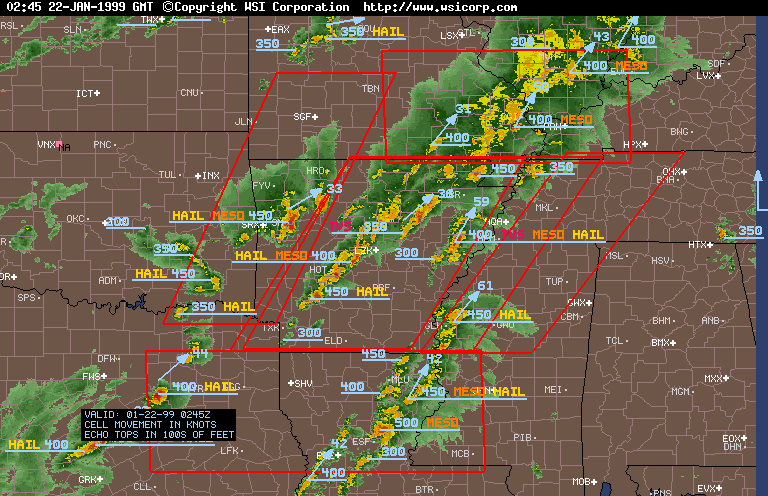
Intellicast Nexrad image from January 21