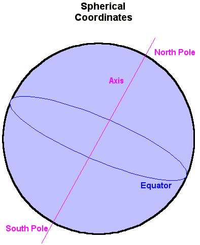

Lines of Latitude can be run north and south of the Equator. These are a series of Small Circles and are shown on the left sphere below. Small circles are circles drawn on a sphere that are smaller than the sphere.
Zero Latitude is the Equator. The North Pole is at Latitude 90 degrees North (written as 90°N). The South Pole is at 90 degrees South (90°S). To the north of the Equator are lines of Latitude running from 0° to 90°N. To the south are lines of Latitude running from 0° to 90°S. All lines of Latitude are parallel to each other.
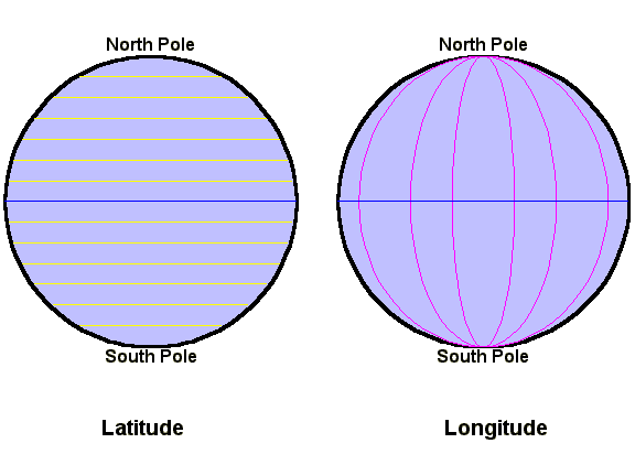
For reasons that we will discuss later, there are four other special lines of Latitude on the Earth. These are given names and are listed below.
| 23.5°N | Tropic of Cancer |
| 66.5°N | Arctic Circle |
| 23.5°S | Tropic of Capricorn |
| 66.5°S | Antarctic Circle |
These four lines of Latitude divide the Earth into climatic zones. The region betwen the two tropics (23.5°N to 23.5°S) is known as The Tropics. The region north of the Arctic Circle (66.5°N to the North Pole at 90°N) and the region south of the Antarctic Circle (66.5°S to the South Pole at 90°S) are called The Polar Regions. The intermediate areas (23.5°N to 66.5°N and 23.5°S to 66.5°S) are called The Temperate Zones and are often split into the North Temperate Zone and the South Temperate Zone. Most of the Earth's population lives in the temperate zones.
Unlike Latitude which has two fixed points (the poles) and a fixed great circle (the Equator), Longitude has no natural zero. All lines of Longitude are identical. The zero line of Longitude is called the Zero Meridian or Prime Meridian. Its position must be decided by international agreement.
The Earth's Prime Meridian was fixed by astronomers and geographers to run through Greenwich Observatory in South East London, England. This observatory was the centre of cartography (map making), time keeping and stellar observation. The zero meridian is now usually called the Greenwich Meridian.
Longitude runs East and West from Greenwich (0° to 180°E and 0° to 180°W). The 180° line of Longitude is called the International Date Line. It passes mainly through the Pacific Ocean.
With these two coordinates (Latitude and Longitude), we can uniquely fix sites on the Earth. Five selected cities are listed below.
| City | Country | Latitude | Longitude |
| London | United Kingdom | 51.5°N | 0° |
| Buenos Aires | Argentina | 35.0°S | 58.5°W |
| Reykjavik | Iceland | 64.0°N | 22.0°W |
| Singapore | Singapore | 1.0°N | 104°E |
| Los Angeles | United States of America | 34.0°N | 118.5°W |
From the above table, it is easy to see that Singapore is the closest of the five cities to the Equator. Reykjavik is the furthest from the Equator and therefore closest to one of the poles. Buenos Aires and Los Angeles are roughly the same distance from the Equator: one in the southern hemisphere, the other in the northern.
Both Latitude and Longitude are measured in degrees. One complete turn is 360°; half a turn is 180° and a right angle (quarter turn) is 90°. On the Earth, one degree of either Latitude or Longitude is equal to approximately 35km. The Earth is divided into time zones. 15° is equal to 1 hour. The Greenwich meridian is the zero for Earth's time zones, again by international agreement.
Each has its uses, advantages, and drawbacks.
The four Cardinal Points (North, East, South and West) are marked at right angles along the horizon. The sky is assumed to be a sphere (the Celestial Sphere) centered on the observer. Half the sky is above the horizon, the other half below. The point directly overhead is called the Zenith. The point directly beneith the observer is called the Nadir.
The Local Meridian is the great circle running from the North point of the horizon through the zenith and to the South point of the horizon. This meridian is very important in time measurements.
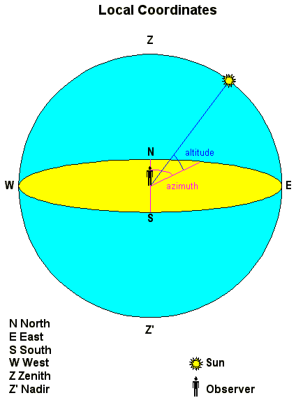
The position of an object (like the Sun) is defined by two coordinates. Azimuth is measued clockwise from the North point. Altitude is measured from the horizon to the object. Both are measured in degrees.
Local coordinates are unique for each individual observer. As the Earth rotates on its axis, objects change their position in the sky relative to the observer. This means that the altitude and azimuth of an object change constantly. The altitude and azimuth of an object in the sky depends on
In particular, the Sun rises from an easterly direction and crosses the Local Meridian. Sunrise is defined as the time when the centre of the Sun is on the horizon while it is moving above the horizon.
In the Northern Hemisphere, the Sun crosses the Meridian due South; in the Southern Hemisphere, the Sun crosses the Meridian due North. Local Solar Noon is the time when the Sun's centre is on the Meridian. The Sun is then at its highest altitude.
At the end of the day the Sun sets in a westerly direction. These motions of the Sun can be used for time keeping. A sundial measures the angle between the Sun and Meridian. The Sun appears to go around the Earth in a 24 hour period. This is a 360° circuit.
24 hours is equivalent to 360°, 1 hour is equivalent to 360 / 24 = 15°.
During a year, the Sun's motion across the sky also changes. This is because the Earth is moving around the Sun. This affects the altitude of the Sun at Noon. The following table shows the effect.
| Location and Date | Sun's Altitude at Noon |
| Northern Hemisphere: December 21st Southern Hemisphere: June 21st |
Lowest Altitude |
| Northern Hemisphere: March 21st Southern Hemisphere: September 23rd |
Average Altitude |
| Northern Hemisphere: June 21st Southern Hemisphere: December 21st |
Highest Altitude |
| Northern Hemisphere: September 23rd Southern Hemisphere: March 21st |
Average Altitude |
For any location on the Earth, the Sun's altitude at Noon is given by the following:
where l is the numerical value of the observer's Latitude.
The table below shows the Sun's highest and lowest altitudes at Noon for the selected cities.
| City | Latitude | Highest | Lowest |
| London | 51.5°N | 62.0° | 15.0° |
| Buenos Aires | 35.0°S | 78.5° | 31.5° |
| Reykjavik | 64.0°N | 49.5° | 02.5° |
| Singapore | 1.0°N | 112.5° | 65.5° |
| Los Angeles | 34.0°N | 79.5° | 32.5° |
The cities of the Northern Hemisphere (London, Reykjavik, Singapore and Los Angeles) have the Sun at its highest Noon altitude on June 21st. Buenos Aires (in the Southern Hemisphere) has its highest Noon altitude on December 21st.
For London, the Sun's altitude at Noon on December 21st is only 15°; on June 21st the atltitude at Noon is 62°. This is why June days are long and warm in London, while December days are cool and short.
Notice that in Reykavik, the Sun barely rises above the horizon in December. In Singapore, the Sun's Noon altitude varies between 65.5° and 112.5°; at some stage in the year the sun must be at an altitude of 90° - in other words, overhead. These figures help determine the climate in the cities.
The sky around the Earth resembles a sphere dotted with stars. This is the Celestial Sphere. Like all spinning spheres, there are two poles through which the axis of spin passes through. These are the North Celestial Pole (NCP) and the South Celestial Pole (SPC). A line passing through the Earth's poles meets the Celestial Sphere at these Celestial Poles. Similarly, the extension of the Earth's Equator meets the Celestial Sphere forming a great circle called the Celestial Equator.
On the Earth, Latitude is the angle North or South of the Equator. The equivalent coordinate on the Celestial Sphere is called Declination (d). This is shown below.
.
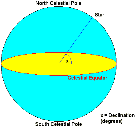
Declination fixes the position of the a star onto the Celestial Sphere. It is not dependent on an observer's location. Declination is set at 0° for an object on the Celestial Equator. Positive declinations are for objects in the northern part of the Celestial Sphere and are 90° on the North Celestial Pole. Similarly, negative declinations denote objects in the southern part of the Celestial Sphere. The South Celestial Pole is at a declination of -90°.
The table below lists selected stars and their declinations.
| Star Name | Declination |
| Sirius | |
| Vega | |
| Betelgeux | |
| Alpha Centauri | |
| Polaris |
The Declination of a star determines from where on the Earth, the star will be visible. It also determines how long the star will be above the horizon.
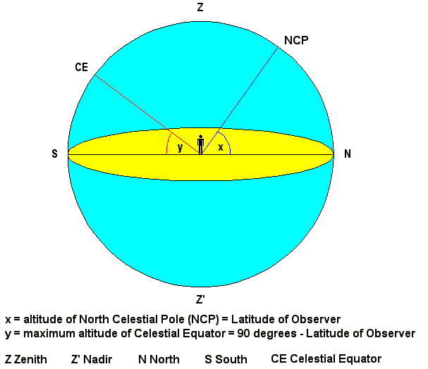
The drawing above shows the sky as seen by an observer in the Northern Hemisphere at a Latitude of l. Everything that is described about this diagram will be reversed for an observer in the Southern Hemisphere.
The observer sees the North Celestial Pole at an altitude of x degrees when looking North. Its position never changes for a given location.
The Altitude of the Celestial Pole (x) is always equal to the Latitude (l) of the observer.
Conversely,
If the Celestial Pole can be located and its Altitude measured, the Latitude of the location can be determined.
Note that in the northern hemisphere only the North Celestial Pole is above the horizon. In the southern hemisphere only the South Celestial Pole can be seen.
For an observer, the Celestial Equator is great circle that rises due East, rises to the Local Meridian (due South in the Northern Hemisphere) and sets due West. Its position never changes for a fixed observer. Exactly half of the Equator is above the horizon; the other half is below the horizon.
The Altitude of the highest point of the Celestial Equator (y) is equal to 90 - l degrees.
For the observer, the sky appears to rotate around the Celestial Pole. Stars move parallel to the Celestial Equator. The visibility of a star for a given observer depends on the star's declination and the observer's latitude. Five scenarios are described below.
on the Meridian, and set due West. Exactly half of the Celestial Equator is above the horizon, therefore a star on the Celestial Equator will stay above the horizon for exactly 12 hours every day.
These stars will be above the horizon for less that 12 hours each day. The further south, the star, the less time spent above the horizon and the lower the maximum altitude. Setting is South of the West point.
These stars will be above the horizon for more than 12 hours each day. The further north, the more time spent above the horizon and the higher the maximum altitude. If the star has a declination equal to the latitude of the observer, the star will pass through the zenith (overhead).
The table below combines the five selected cities (with their latitudes) and the five selected stars (with their declinations) to determine their visibility. Remember,
l = 51.5°N |
l = 35.0°S |
l = 64.0°N |
l = 1.0°N |
l = 34.0°N | |
| Sirius d = -16.5° |
Visible | Visible | Visible | Visible | Visible |
| Vega d = +38.5° |
Circumpolar | Visible | Circumpolar | Visible | Visible |
| Betelgeux d = +07.5° |
Visible | Visible | Visible | Visible | Visible |
| Alpha Centauri d = -60.5° |
Not Visible | Circumpolar | Not Visible | Visible | Not Visible |
| Polaris d = +89.5° |
Circumpolar | Not Visible | Circumpolar | Circumpolar | Circumpolar |
Stars near the Celestial Equator (like Betelgeux and Sirius) tend to be visible from many locations on the Earth. Stars with high positive declinations (like Vega and Polaris) tend not be visible from the southern hemisphere and may be circumpolar at high northern latitudes. Stars with high negative declanations will tend not to rise from northern hemisphere cities and may be circumpolar from southern hemisphere cities.
Stars have a fixed declination so their visibility remains the same for a given location. However, the Sun's declination varies throughout the year. This was hinted earlier when the Sun's maximum altitude was shown to vary throughout the year. The table below shows the Sun's declination during the year.
| Date | Declination of the Sun |
| March 21st | |
| June 21st | |
| September 23rd | |
| December 21st | |
| March 21st |
The reason for this is because the Earth moves around the Sun taking a year to do so. The Earth's axis of rotation is inclined to the plane of the Earth's orbit by 23.5° The Sun doesn't only change its declination; it also moves around the sky, taking a year to travel back to its starting point. The Apparent path of the Sun on the Celestial Sphere is a great circle inclined to the Celestial Equator by 23°. This path is called The Ecliptic and is shown below.
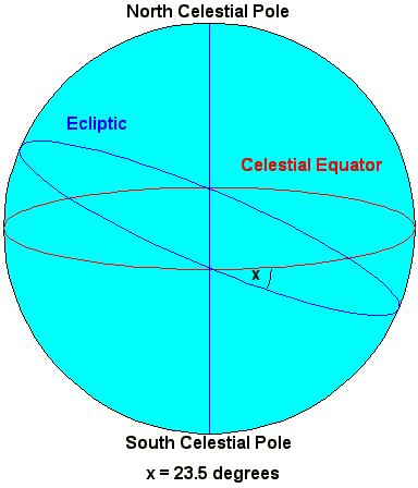
The Ecliptic is the path of the Sun across the sky during a year. The Moon and planets also vary their positions and travel around the sky. They, too, stay close to the Ecliptic.
There are two points where the Ecliptic intersects with the Celestial Equator. These are called nodes. On one node, the Sun moves from South to North as it crosses the Celestial Equator. This node is called the Vernal Equinox because (in the northern hemisphere) it marks the beginning of spring. It is also called The First Point of Aries, for historical reasons.
The Equatorial Coordinate system requires a second coordinate analogous to the Earth's Longitude. This is called Right Ascension. The zero for Right Ascension is the Vernal Equinox point introduced above. Like longitude, there is no natural zero for Right Ascension. The Vernal Equinox was chosen with international agreement by astronomers.
Right Ascension is measured eastwards from the Vernal Equinox. It can be measured in degrees (from 0° to 360°). It is far more commonly measured in units of time. Right Ascension is very closely related to time because time is measured by the rotation of the Earth.
The table below shows the Sun's declination and Right Ascension throughout the year.
| Date | Declination of the Sun |
Right Ascension of the Sun |
| March 21st | ||
| June 21st | ||
| September 23rd | ||
| December 21st | ||
| March 21st |
The five selected stars can also be tabulated with their complete positions on the celestial sphere.
| Star Name | Declination | Right Ascension |
| Sirius | ||
| Vega | ||
| Betelgeux | ||
| Alpha Centauri | ||
| Polaris |
Ecliptic Coordinates are used for Solar System calculations involving planets, comets, asteroids, etc.
© 2001 Kryss Katsiavriades
