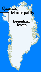
The Small Settlements - and other interesting places.
|
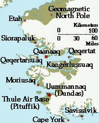
Savissivik - a hunters settlement in Melville Bay.
Moriusaq - a small settlement near Thule Air Base.
Qeqertat - a hunters' very small settlement in the inner part of Englefield Fiord.
Siorapaluk - The world's most northernly naturally inhabited settlement.
Qeqertarsuaq - (Herbert Island) an abandoned village near Qaanaaq.
Uummannaq (Dundas) - the village from where the inhabitants were forced to move
in 1953 because of Thule Air Base military activities.
Kangerluarsuk - an abandoned small settlement in Bowdoin Fiord.
Etah - once the northernmost village.
Cape York - with the impressive Peary Monument.
The Geomagnetic Northpole - one of the Earths geomagnetic poles
is about 70 miles (130 km) north of Qaanaaq.
|
|
|

Savissivik
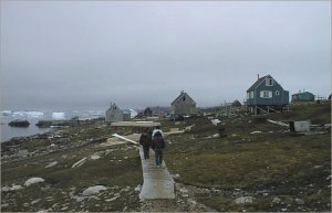 In the northern part of the Melville Bay is the settlement Savissivik.
It is the southernmost inhabited place in the district. Once a cluster
of meteorites fell down in the area and that is why this place is called
Savissivik (savik = iron/knife). During this century several meteorites
have been shipped out of this area - some of these are very big and heavy. One meteorite weighing approximately 20 tons (900 kg) was retrieved in 1968 and taken to Denmark's Geological Museum. It is the world's 6th largest meteorite.
A part of a small meteor can be seen at the local Thule Museum in Qaanaaq.
In the spring and summer the cliff just above Savissivik is the
breeding ground for hundreds of thousands of birds named the Dovekie (alle alle) but here called simply "auk". In the season this
little delicious auk is eaten in great numbers by the local people.
The Melville Bay is an important breeding area for narwhales, seals
and for the polar bear. The inner parts of the bay are declared a national
park, where any kind of traffic or hunting is prohibited. Because of the
enormous glaciers in the area, and the bay-shape, the sea is
covered with ice very early in fall and breaks up very late in summer.
During some years it is possible to practice dogsledging all year round.
Because of the rich fauna, the hunting is extremely good. The most
commonly hunted animal is the seal, but narwhales and polar bears
are frequently caught throughout the year.
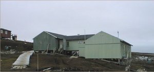 Savissivik has a big common facility called the "Servicehouse". It
has multifunctions like administration, meeting place, public bath, and
facilities for washing.
Royal Greenland has a very small department in the village for producing
arctic halibut, meat from seal and narwhale, and auks. The production
is shipped out in summer for the Greenland homemarket.
Savissivik has a store with new storage facilities, so the village
is well supplied all year round. Supplies are brought in with the yearly
ship in August. By air the village is serviced by a small Bell helicopter
showing up normally once or twice a week. The helicopter brings passengers, mail, and some needed supplies to and from the village. In the
dark time of the year with bad weather, there may not be helicopter service for
2 or 3 weeks.
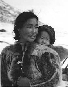 A small power plant supplies the houses with electricity. The water
supply is a private matter and is mostly done by melting small pieces of
icebergs in-house.
The school is being modernized in 1998/99 with new and modern teaching
facilities and a small public library.
There is a small church in Savissivik with regular services.
The KNR (Radio Greenland) is broadcasting TV and radio
daily. The broadcast comes directly from a satellite. There are
phones in most private homes and institutions.
There are no medical services in Savisivik except for a person handing
over medicine according to instructions from the hospital in Qaanaaq.
Every year though, the settlement is visited by a medic and a dentist.
Inhabitants 1998: Approximately 110.
Moriusaq
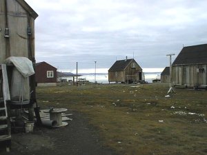 Only about 16 miles (30 km) from the American Thule Air Base is the small
settlement Moriusaq. Hunting in the area is good and there are still some
hunters there. During the last few years several families
have moved away - especially to Qanaaq - where facilities and supplies
are better. This might change as more modern facilities have been recently established
in Moriusaq.
Facilities available are: direct TV and radio broadcasting, private
phones and a small power plant for electricity.
Moriusaq has a small store, school/church and library.
Every year the settlement is visited by a doctor and a dentist.
Inhabitants 1998: Approximately 40.
Qeqertat
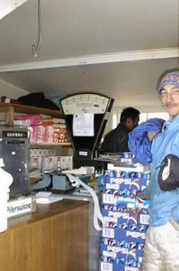 Qeqertat is a very small settlement in the inner part of the Inglefield Fiord east of Qaanaaq. For long times when one can neither go by sledge nor
boat it is a rather isolated place. The local helicopter is not servicing
the settlement, and there is only one phone. There is no store in
Qeqertat, but a small depot that can be opened on request at almost any
time if you want to buy the most needed daily things like coffee, tea, sugar,
salt, chocolate, soap, matches, fuel and so on. There is a
combined school/church with a small public library.
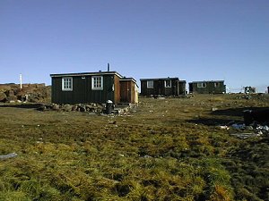 Qeqertat is now the only permanently inhabited place in the district without
electricity. But in summer the number of inhabitants is often doubled because the place is used much by hunting parties hunting narwhales. Also during winter there are many visitors
staying for longer periods and fishing for halibut near the settlement.
Every year the settlement is visited by a doctor and a dentist. Inhabitants 1998: Approximately 22.
Siorapaluk
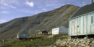 Siorapaluk is the district's most northern settlement. Almost all year
round there is good hunting close to the settlement. All the cliffs
around Siorapaluk are bird breeding grounds for millions of Dovekie (alle alle) -known here as the "auk", and the Thick billed murre (uria lomvia), called the "murre" here.
Many foxes and arctic hares are caught close to the village.
Of the sea mammals, especially the seal and walrus are hunted.
Siorapaluk has an electrical power plant, direct satellite radio
and TV-broadcasting, and common phones. A few years ago a new
store was built and it is usually very well supplied all year round.
School is combined with church and a small public library.
Every year the settlement is visited by a doctor and a dentist.
Many of the inhabitant are direct ancestors of the last migration
from Canada in last century.
Inhabitants 1998: Approximately 60.
Qeqertarsuaq
The settlement Qeqertarsuaq (Herbert Island) is now almost abandoned.
Until the late 1980's it was permanetly inhabited because
the hunting in the area was really good. But families gradually moved
to the more comfortable Qaanaaq not far away, and since the small depot
with daily supplies was abandoned in 1994, only very few people have stayed
permanently at the place.
There are still many good houses in Qeqertarsuaq often used by hunting
parties or as a recreation facility for tourists or workers from Qaanaaq.
The school and library is built together with the very nice little
church with its full functional interior.
Inhabiants 1998: Approximately 2-6.
Uummannaq (Dundas)
Uummannaq (Dundas) once was the natural center for the very sparse and
scattered Inuit population - with a store and a medical facility.
Hunting in the area was good, so for many reasons it was popular to stay
at this place for longer periods.
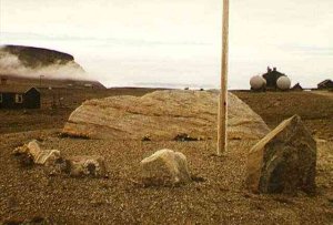 In Uummannaq a stone is raised in memory of the polar explorer Knud Rasmussen.
He established Uumannaq as a trading post in the beginning of this century
and later provided a small hospital mostly financed with incomes from the
trading station.
 Shown here (in 1968) is a hunter's hut insulated against the wind and cold with sod cut from the rich soil on the plain here. During the summer, with sunshine 24 hours-a-day, the rich glacial soil sprouts abundant lichens and grasses. This provides a renewable building materal that can withstand the pounding wind coming down off the ice cap.
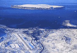 In 1951 the building of the military American Thule Air Base started.
It was in the days of the very cold war. Due to military activities
(defence of base against enemy air attack) Danish and American authorities
in 1953 agreed that the Inuit population had to leave Uumannaq and settle
down outside the defense area. The inhabitants had to move within
a few days. Most of the families chose to move to Qaanaaq where a
new village with substitute houses was being planned to be built.
The Inuits left Uumannaq with fully loaded dogsledges in May while they could still travel over the frozen sea ice.
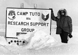 From the Thule air Base it is not far to the ice cap where the surface is
relatively smooth and not at all steep. So at the edge of the ice cap Americans
established "CAMP TUTO". For many years it served as a supply station
for the many scientific/military projects on the ice cap.
 According to official declared Danish policy, nuclear weapons could not
be situated on Danish ground, sea or air.
In 1968 a B-52 long distance bomber loaded with 4 nuclear weapons had a fire while orbiting over Thule Air Base waiting for the "GO" signal, should it be given in the event of war. Thule was one of the holding points for at least one B-52 waiting 24-hours a day for the "GO" signal. After the fire was out of control the crew parachuted over the base and let the
airplane continue to go down on the sea ice between the base and the settlement of
Moriusaq. The sea ice was approximately 5 feet thick at that time of year. The aircraft and weapons hit at an angle and broke up and burned on the sea ice surface. There was no nuclear explosion. Hunters from Moriusaq were the first people to arrive at the wreck spread on the ice. Walking around in the wreck looking
for possible survivers, they were not aware that they were in fact
stepping on several smashed nuclear bombs.
Later it became clear that Denmark had an "unofficial" nuclear
policy too, as Danish authorities very well knew - and accepted - that
nuclear devices for air defence missiles and bomber planes were stored at the base. However, they demanded, and the Americans complied with, removal of all wreckage, radioactive materials, and contaminated ice. Many huge steel gasoline storage tanks were filled with the debris and contaminated ice, then welded closed, and shipped back to the U.S. the following summer.
 After "the Cold War" had ceased, and as nuclear bombers are of no strategical
value compared to intercontinental missiles and satellite survaillance,
the military importance of Thule Air Base today is minor. There are
still long distance radars for the early-warning-system aginst missile
attacks on North America But the most important installations right
now are probably communications, support, and the satellite tracking facility
"checking out" the many hundreds of objects circling around earth.
Of the approximately 800 persons on the base right now, most are
civilians and an increasing number are Greenlanders.
Kangerluarsuk
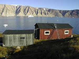 In Kangerluarsuk (Bowdoin Fiord) just about 10 miles east of Qaanaaq, is
the little former settlement of Kangerluarsuk, placed on a small green cape.
There are only three buildings remaining. One is owned by the school
in Qaanaaq and was donated by personal at the Thule Air Base after an
American military plane crashed during landing at Sondre Stromfiord Air
Base in the 1970's. Several pupils from Qaanaaq were passengers and
died in the crash.
Now and then teachers with their classes from Qaanaaq stay here
for a week or so and practice skills in hunting and outdoor living.
But the hut is often used by hunter families, as there is very good
hunting nearby. In fall Kangerluarsuk is visited
also because of the many berries collected.
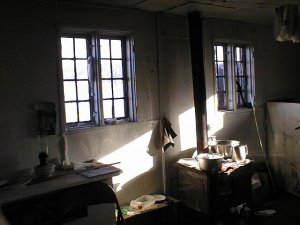 Another old and well kept hut is also regularly used by hunterfamilies.
For some years the old couple Inuutersuaq and Naduk Uvdloriaq lived here.
It was Inuutersuaq, who told the story about the last migration from Canada
to the Qaanaaq area last century. He was told the very dramatic
story by his parents and family. Now it is all written down and preserved
for future generations.
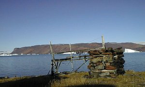 A pile of stones, where meat could be stored out of reach of the always
hungry dogs, is all covered with old blubber, telling that this is
a good place for hunting. Mostly seals and narwhales are hunted
in this small fiord.
Etah
Once Etah was the most northern permanently inhabited settlement.
It is in the bottom of a very small fiord surrounded by mountains all covered
with breeding auks. The hunting in the area was very good - especially walrus hunting. Canada is only about 30 miles away and
the hunters from Etah often went on long hunting trips on the Canadian
side hunting the polar bear.
For some years there was a small store
and trading post in Etah. The very harsh climate with an extreme
cold and almost constant northern wind caused the people to gradually move
south closer to the more friendly Qaanaaq area. There are still
huts in Etah and they are still used as shelter for hunting parties going
out hunting for longer periods.
Cape York
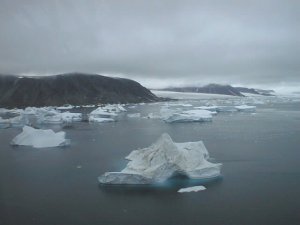 Not far from the settlement of Savissivik, in direction west-south-west, is
Cape York. Looking at a map, the coast seems to be very rough
but in the past it has been an excellent place for hunting.
In the spring and summer, millions of birds - auks and murre - are here. In winter many seals, narwhales, and polar bears gather at the huge cracks in the sea ice caused by strong currents and wind. The yearly catch of polar bear in the Cape York area
is 20-40 animals.
Almost any little inlet has a trace of human visitors of newer or older dates. The American, Admiral Peary, is said to be the first man on the North Pole. He was accompagnied by several polar Eskimos. The was reached after several attemps in april 1909. On the very eastern point on Cape York, Peary's family later raised a tall stonemonument in memory of his achievments.
When European whalers were hunting whales in the Melvile Bay, they
often climbed the Cape to get an overlook on the always changing ice.
Since the ships were only travelling by the power of the wind, a good overlook could sometimes
spare many days and troubles.
The Geomagnetic North Pole
The Geomagnetic North Pole is in the land mass called
Inglefield Land. In that area are unknown numbers (not very many)
of caribou and muskox, and along the Inglefield Land coast there are very
fine resources of sea mammals. Not many years ago the coast was inhabited
by a few families staying there in longer periods of the year, but the last
few years it has only been visited only by hunters roaming around on longer
hunting tours mostly looking for the polar bear close to the enourmous
Humbolt Glacier. The front of the glacier is about 55 miles long in an unbroken
straight line.
The Geomagnetic North Pole is one of three "poles" near the top of the earth. There are similar and opposite poles in Antartica. The Geographic North Pole is defined as the northern axis of the earth's rotation. It is directly opposite the Geographic South Pole. For map and navigation purposes both geographic poles are known as 90 degrees latitude North and South.
The magnetic north pole is that point where a magnetized compass
points. The magnetic north pole has moved slowly over the years and is presently at the north end of Hudson Bay in Canada. A compass is of little value in the Qaanaaq area because north is indicated as being almost due west!
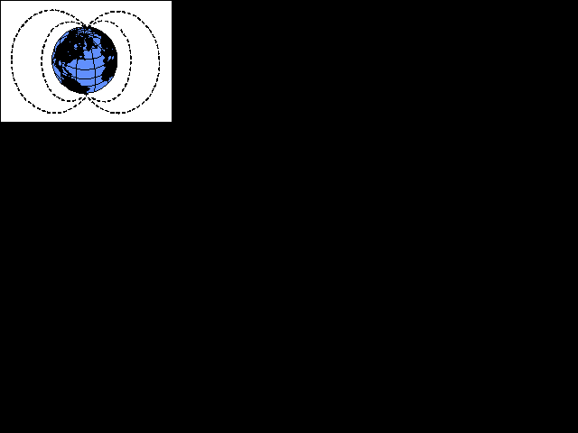 The Geomagnetic North Pole is the theoretical pole where particles from the sun are attracted to enter the earth. If you could look at earth from a far enough
distance, and envision the magnetic field caused by its molten iron core, that magnetic field would resemble the pattern that iron filings make around a bar magnet.
 As particles stream down from the sun, the earth's magnetic field deflects them away from the Equator and toward both geomagnetic poles following the magnetic field lines.
The particles travel along the magnetic field lines toward the geomagnetic poles at high velocity. When they hit air atoms in the upper atmosphere 50 to 600 miles up, they cause a visible glow that appears as a circle around the geomagnetic pole. This glow is called the "aurora borealis", or "northern lights". There is a similar phenomina at the South Pole at the same time.
The northern lights are not as easy to see in the Qaanaq area as they are in other places farther away such as Alaska, Canada, and Northern Europe. When they do occur, the kids whistel to the northern light to make it come closer. The Inuit name for northern light is "arsanerit", which means something like "ballplaying". The small kids are told
that if you whistle, the light will come down and play ball with your heads. (Picture taken by NASA spacecraft Dynamics Explorer 1)

Back to top on this page
Back
to Directory
Counter for statistical purposes and may be reset: 


 After "the Cold War" had ceased, and as nuclear bombers are of no strategical
value compared to intercontinental missiles and satellite survaillance,
the military importance of Thule Air Base today is minor. There are
still long distance radars for the early-warning-system aginst missile
attacks on North America But the most important installations right
now are probably communications, support, and the satellite tracking facility
"checking out" the many hundreds of objects circling around earth.


 As particles stream down from the sun, the earth's magnetic field deflects them away from the Equator and toward both geomagnetic poles following the magnetic field lines.
The particles travel along the magnetic field lines toward the geomagnetic poles at high velocity. When they hit air atoms in the upper atmosphere 50 to 600 miles up, they cause a visible glow that appears as a circle around the geomagnetic pole. This glow is called the "aurora borealis", or "northern lights". There is a similar phenomina at the South Pole at the same time.