
|
 |
|||
|
Photo by Alan Bow |
||||

|
|
|||
| Photo by Alan Bow | ||||
|

|
|||

|
|
|||
|
Old Rag Mountain Loop Trail
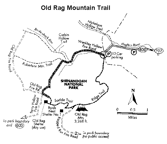
Description Finding the trailhead: The most popular and easiest way to climb Old Rag is to access the trailhead from outside the park. We recommend using a good road map, such as the Virginia Atlas and Gazetteer. If you're in the North District of the park, from Mile 31.5 at Thornton Gap on Skyline Drive, take U.S. Highway 211 east to Sperryville, Virginia. From Sperryville on US 211, turn onto U.S. Highway 522 south. Go 0.8 mile, turn right onto Virginia 231, and go 8.0 miles. Turn right onto Virginia 601. In 0.3 mile, turn right at intersection. Continue on VA 601 until it becomes Virginia 707 some 0.8 miles later. In 1.7 miles the road becomes Virginia 600 (bearing left); follow it for 0.5 mite to the parking lot on the left, which is clearly marked. From here you must walk 0.8 mile to the trailhead at the terminus of VA 600. On very uncrowded days, try driving up VA 600 to the small parking lot at the trailhead, but it fill, rapidly. From the south {Charlottesville, Virginia) take U H. highway 29 about 35 miles north to Madison, Virginia. From Madison, Ink, Virginia 231 north for 12.8 miles. 11, left onto Virginia 602. 1, 0.5 mile the road becomes Virginia 601. Continue on VA 601. in 0.8 mile, it becomes VA 707, and it becomes VA 600 1.7 miles later. Follow VA 600 for 0.5 mile to the parking area on the tell. Access the blue-blazed Ridge Trail. The hike: The rocks of Old Rag are among the park's oldest. Billions of years ago, the granite that forms the crest of Old Rag was thousands of feet underground. With lime, the rocks uplifted to the point where they now perch atop this 3,268-foot mountain. At the same time, the igneous rock that once surrounded today's boulders eroded and exposed them. Seeing these rocks shrouded in all the various weather conditions is one of the wards of hiking to the summit of Old Rag. Another reward includes completing a quick self-taught course in "Rock Climbing 101' as you scramble over and under boulders. Just be sure not to limb on days when the rocks wet. No pets arc allowed on the Ridge, Trail or the Saddle Trail. Because of Old Rag's, popularity, the Park Service has implemented a management plan. As part of heat plan it suggests you consider climbing Old Rag on weekdays, particularly during the popular fall hiking season. Overuse has already created abuse of the mountain, and hikers parking on private property have caused some ill feelings among local landowners. Presently the park is working with landowners to improve its strategy so that all may enjoy this area. If the parking lots are full, do not park on nearby private property but drive elsewhere for an alternative hike. The park also recommend that hiking groups car-pool and not send out groups by the busload. The National Park Service enforces strict parking regulations at the trailhead. Anyone over 10 without a seven-day pass, a yearly pass, or Golden Eagle or Golden Age pass most buy a $5 permit. Such permits are available from park personnel on busy weekends and holidays or by self registration at the trailhead. If you plan to stay in the backcountry, obtain free backcountry permit from one of the visitor centers or from the Syria Mercantile Store. The park prohibits camping at elevations over 2,800 feet on Old Rag. Nor is camping permitted near Byrds Nest Shelter No 1. Byrd, Nest Shelter No. 1 and the Old Rag Shelter are for day use only; no hikers may camp out of sight near the Old Rag Shelter. If crowds are minimal and the two lots open, you may begin your hike from either the lower or the upper parking lot. During crowded periods, you'll have to begin from the lower lot as the upper one-0.8 mile away will be full. From the trailhead proper, the hike begins by progressing along the Ridge Trail Within a short distance after leaving the trailhead, a cautionary sign advises leaders to maintain control over their groups. "Each year," says the sign, "the part, spends thousands of tax-payer dollars looking for youths who run ahead of then group and get lost by short-cutting switchbacks." During the first 0.75 mile the trail is wide, then it begins to get narrow and rocky. About 1.0 mile along the trail, huge boulders appear through the forest, hinting at what lies ahead. A small stream that is about sole deep greets you in July; in spring the stream may be a torrent. The forest canopy soon opens, offering a view of a nearby mountain range. About 1.5 miles along the trail the vegetation closes in. A short distance later, the hike stops and the crawl begins. For about 1.0 mile or more, you must shinny over boulders using, in places, three point stand.,. Those who have mastered elementary rock climbing techniques have an advantage. Some, ho- ever be alarmed by the heights, and one man we encountered decided to turn back. He was mart, for he knew his limits. Others have slipped and fallen, and some have broken bones. Yet others, such as Senator Byrd, have made annual climbs of Old Rag even at advanced ages--well into their late seventies! Regardless, the going is slow and requires a while to navigate the labyrinth of rocks. The route is well marked with blue blazes, and without them route finding could be exceedingly difficult. Pay attention to the blazes; after reaching one, look for the next before proceeding. Though the trail becomes more obvious after threading through the maze, another maze soon follows. Fortunately, this one is much easier to negotiate. Shortly after the second maze, you reach the summit of 3,268-foot Old Rag. The summit is marked by a cement post. Go past it on the right to get the full effect of the views. From the summit, you have the option of either retracing your steps or following the longer but easier route back to your car. Timewise, it is probably a tossup, but remember, if you return by the route, you must scramble down the boulders and, for most, this is more difficult than climbing up. We returned by the longer route, leaving from the summit of Old Rag and proceeding 0.4 mile down to Byrds Nest Shelter No. 1. Another mile and we ..ached the Old Rag Shelter. From there the had continues downhill. At mile 4.6-about 0.25 mile past the shelter-turn right onto the Weakley Hollow Fire Road at the cement post marked "Old Rag Parking." The fire road is mostly level; finally, it parallels the Hughes River. Just before reaching the upper parking lot, the trail crosses three footbridges over the river. As you reach the fourth footbridge 0.1 mile beyond the other three, you're early at the upper parking lot. If your vehicle is in the lower lot, there is 0.8 mile left to this hike. |