 |
Before the Indians, came the glaciers. They carved great valleys before they receded. The Penobscot River Valley was a bay when the Native Americans began to
populate the region. These early Americans moved throughout the area
seasonally, following the game, fished for salmon, and made journeys to
the Chert Mines to gather stone for arrowheads and other stone-age tools.
To these people the simplest way of travel was the canoe. The central
plateaus of Maine and New York provided this network of waterways composed
of streams, rivers, lake chains which allowed travel by canoe. They
remembered the easiest portages and foot traffic kept them cleared. These were the highways, the network of waterways.
Early forays by the European trappers and explorers followed the trails
and habits of the Native Americans, utilizing the canoe trails for transportation.
One of the more famous expeditions into the wilderness of the region was
the planning of the conquest for the takeover of Quebec City from the British.
Led by Benedict Arnold, a gathering of troops set out from Arundel, Maine
( now Kennebunk), went upstream on the Kennebec River to the Dead River,
then carried the boats and belongings through the thick woods to the Chaudierre
River and floated down to the St. Lawrence Seaway across from the new city
of Quebec. A major undertaking in primitive conditions. You can read a great story about this in Kenneth Robert's "Arundel".
The Fish River will lead us into the heart of Maine. We'll go upstream to the town of Portage. Twelve foot long poles will
replace paddles on the Fish. We will stand in our canoes and push our way against the current until we reach a chain of lakes, where the poles become masts and we'll sail across the lakes to Portage. Aptly named, that's what we'll do to get to the Little Machias River for the downstream paddle.
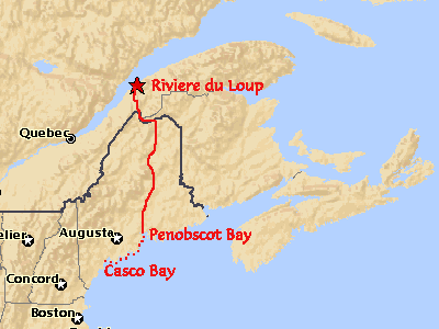
A couple hundred years later two canoeists come along. That's us, Scooter and Hal. We started looking
for a route that followed old trails and highways. Our goal is to
start on the St. Lawrence Seaway and make our way upstream to the headwaters
of the St. Francis River via the Riviere Du Loup. A five mile portage will take us to Lac a Charmand.
Crossing this lake another short portage will take us to Lac St. Francis
and the headwaters of the St. Francis River. We will paddle down this and the St. John River to the town of Fort Kent. The
St. John River marks the boundary of Canada and the United States.
At Fort Kent they will re-supply and head into the interior of Maine.


Upon meeting the Aroostook River, we'll once again break out the poles and make our way upstream to the ancient Chert Mines at Norway Bluff. The Native Americans came here to gather this stone to chip into arrow and spear heads. From this point we'll have two options.
The first option is to float back down to the La Pomkeag and pole up to Snowshoe Lake to the Sebois River through beautiful gorges finally ending up on the Penobscot River. The second option is to head west through Munsungan Lake and into the chain of lakes which form the upper Allagash, down the West Branch of the Penobscot River.Either way, this river will take us down to the Atlantic Ocean where, if time allows, we will switch to kayaks and begin down the coast following the Maine Island Trail to Cousins Island.
All told the trip will take the month of June, soloing our own boats outfitted for paddling, poling, and sailing. The this trip will be 400 to 500 miles in length.