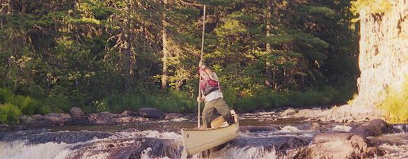
| Launching off a ledge. |

| Launching off a ledge. |
JS was to meet me at noon. I ambled down to shore, cup of cowboy coffee in hand, about 8. A decent breeze was already starting, blowing right in to shore. As I enjoyed the view up the lake from the comfort of the lawn chair, I caught a glint of red. "No way! That's him already!" I could see my plans to hang out and write more in my journal were about to change. Sure enough, the wind blew JS into camp around 9:30. He was quite jealous of my site. "You even had a lawn chair, you Bastard!" Haw, it was great.
In no time, I was packed and off we went in search of the outlet. We paddled out a hundred feet from shore and hoisted our sails. It was pretty exciting, with the wind blowing directly into shore, and us sailing parallel to it. The wind quickened and a loud hum emanated from the rigging as we left white wakes down the lake.
We found the outlet at the bottom of the east side of the peninsula. It was pretty sheltered from the wind. I tried sailing further while Jumbo dropped his and began to paddle. He soon overtook me and I followed suit. The Seboeis River was no more than a stream at this point, and low on water at that. On the run down to Snowshoe Lake, I saw that some one had taken the time to clear rocks from the center of the flow, making it a nice little channel just big enough for a canoe.
We poled down that garden path and soon entered the lake. JS had the map so I let him navigate to the outlet. I'm not sure what he did, maybe read the scale wrong, but we followed the east shoreline looking for the outlet and not finding it. Then he saw a boat ramp that was on the map and said it had to be beyond that, so we paddled across a cove and kept following the shore. After we had paddled about three quarters of the shoreline, we entered a stinky little stream. Each paddle stroke stirred up a cloud of fetid muck, followed by huge bubbles of nauseating swamp gas. He led for awhile, then I led for a while. After we got up a few hundred yards, I studied the weeds and determined we were going upstream. So he tossed me the map and turned around.
Following Jumbo, the water was all stirred up. I got hung up on a log because I couldn't see it and fought for a long time with my pole to get free. There was no way I was going to step out in that mire. Eventually I reached the outlet, but JS was already out retracing the shoreline back the way we had come. By now the wind was pretty heavy and I had no desire to waste any effort out there. I studied the map, found the stream we were in, and took a compass heading for the outlet. Sure enough, I could see a low point on the horizon that was the river valley.
I was pissed at JS for getting us into this, dumping the map in my lap and taking off. So when I got out into the lake, I vented my anger on the paddle and pulled hard across the lake in a beeline to the outlet. JS soon abandoned the shoreline and trailed me to the outlet. We reached it, and it was the one cove we skipped when we headed for the boat ramp.
The stream was still very low, and no one had cleared the rocks from the channel. We hit bottom a lot, and had to get out and drag the boats in places. There were many pond-like openings in the stream, and seemed very remote. I would have liked to camp along this section. I was very happy to see Whitehorse Lake. The lake is a small, nondescript thing, but it had enough water in it. I figured every time we hit a lake, the water level had a chance to get better.
We drifted and lunched, then crossed the lake and started the Seboeis River in earnest. The Seboeis River, at low water, was a lot of chutes and rock dodging until we got to the gorge. Scared the crap out of a couple of fly-fishermen, coming around one of the corners. We stopped and talked, one of the guys had tried the gorge and lost a canoe. It was tough to stop and look at the scenery, as the walls rose around us and we descended into the gorge; snubbing down through the drops took all my attention.
We came to a gorgeous spot, decided it must be Godfrey Pitch and set up camp. We started a fire about two feet from the water's edge, which would normally be under water. Finding a tent site was a neat trick, as the whole area was either bare rock or steep slope. I finally found a spot that passed as sort of level, but far from flat. I set up my two-man tent and we both had to level off our sleeping pads by stuffing whole sacks full of clothing under the hollows. It was a beautiful spot, but the roar of the water and having to shout made me weary. I slept real well that night.
