Tour One:
THE TRANS-LABRADOR HIGHWAY

Grand Lake: The view from Sunday Hill in North West River. At the northeastern-most point on the North American highway network, the community truly is at the end of the road. Surrounded on three sides by water, there is a million-dollar view from the crest of Sunday Hill: your reward for traversing the Trans-Labrador Highway. Be sure to come at sunset.
INTRODUCTION
Yes, you can drive to the far north and the far east of the North American continent. The Trans-Labrador Highway was opened in 1992 with the completion of the Ossakmanuan Narrows bridge and causeway. To get to Labrador from the rest of Canada or the United States, there are several options:
From Quebec City or Montreal, take the North Shore Highway, Route 138. This is a scenic drive along the beautiful St. Lawrence Valley. Along the way you cross the spectacular Saguenay River at Tadousac. At Baie-Comeau the road divides. Route 389 strikes off into northern Quebec and Labrador. It passes the dam at Manic-5, and the enormous Manicouagan Reservoir. This lake fills the scar of a meteorite impact that occurred millions of years ago. The 389 continues through the ghost town of Gagnon, and on to the mining centre of Fermont, Quebec. It is located just across the border from Labrador City and Wabush, the gateway to the Trans-Labrador Highway.
Alternatively, from Baie-Comeau you can continue on to Sept-Iles and the Lower North Shore on Route 138. Sept-Iles is the shipping centre for iron ore from the mines in Labrador City and Wabush, and is the terminus of the Quebec North Shore and Labrador Railway. The QNS&L carries passengers along an incredible wilderness route. Sept-Iles is also the transportation hub of the Lower North Shore, and you can continue your journey in this roadless region by coastal ferry. This service, operated by Relais-Nordik, serves the communities of the beautiful Gulf coast, and will bring you to Blanc Sablon and the South Coast of Labrador.
Finally, you can drive to Newfoundland via Canada's Maritime Provinces. Marine Atlantic ferries cross the Cabot Strait from North Sydney, Cape Breton Island, Nova Scotia, to Port-aux-Basques or Argentia Newfoundland. From the Newfoundland end of the ferry runs, you make your way to Lewisporte on the northern coast of Newfoundland. It is the Newfoundland base for the Northern Ranger, the Marine Atlantic coastal boat which serves the North Coast and South Coast of Labrador. This is also the southern terminal for the Marine Atlantic ferry Sir Robert Bond, which travels to Cartwright and Happy Valley-Goose Bay, Labrador.
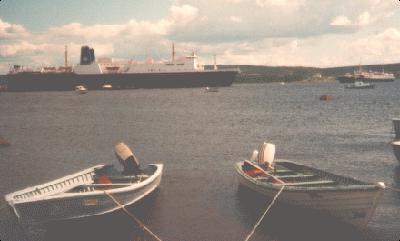
The "Bond": Marine Atlantic operates the MV Sir Robert Bond, which is the marine extension of the Trans-Labrador Highway. The Bond sails from Happy Valley-Goose Bay to Cartwright, linking the Trans-Labrador Highway to the Newfoundland highway network.
THE TOUR
The Trans-Labrador Highway, Highway 500, can be traversed from westward or eastward. This tour will start in Labrador West and head east. The towns of Labrador City and Wabush are located just inside the Labrador border, high in the Labrador interior. They grew up in the 1960s around the open-pit iron mines which are the region's main industry. This whole region is rich in iron ore, which is mined at two locations: Wabush Mines in Wabush, and the Iron Ore Company of Canada (IOC) at Labrador City. The operations are on an enormous scale: millions of tons of iron ore are carved out of the earth each year by enormous earth-moving machines, crushed and processed, and shipped by rail to Sept-Iles on the Gulf of St. Lawrence. To arrange a tour of the mines, call 1.709.944.7788
Continuing along Highway 500, the route crosses the QNS&L Railway and strikes off towards Churchill Falls. This community supports the operation of the enormous power plant which harnessed the energy of the Churchill Falls (formerly Grand Falls.) One of the largest hydroelectric developments in the world, it came into service in 1971. The river is diverted upstream from the falls, and channeled through the giant underground power plant before being discharged into the deep river gorge below. The station generates over 5,000 megawatts of power which is transmitted across Quebec and into the United States. Tours of the plant can be arranged by calling 1.709.944.7788. The waterfall and the spectacular Bowdoin Canyon can also be visited by driving west from the community of Churchill Falls along the Trans-Labrador Highway. A short trail leads to several viewing points along the edge of the gorge. Don't forget your camera!
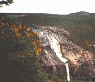
Churchill Falls: While the Churchill Falls today is but a remnant of what it once was, the site is still impressive. Located at the head of a 300-foot deep gorge, surrounded by steep cliffs and thick forest, the Falls is one of the most photographed spots in all of Labrador, and is especially striking in the muted colours of an early Labrador autumn.
The Trans-Labrador Highway continues east from Churchill Falls through some beautiful country. The road passes through the Wilson River region, an old burnt area which explodes with colour in Labrador's crisp, cool September. The highway also traverses the valleys of the main tributaries of the Churchill River, including Pinus River, Metchin River, and Gull Island Brook. Through these valleys flow quiet and pristine rivers, peaceful spots for stopping along the way. Nearing Happy Valley-Goose Bay you also pass the turnoff to Muskrat Falls. A path leads to the summit of an ancient volcanic plug several hundred feet high, affording an unforgettable view of the river valley, the double waterfall, and the whirling rapids and pool below.
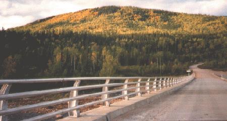
Pinus River: Early fall on the Trans-Labrador Highway. This is one of the best times to make the drive through Labrador. The crisp fall air is invigorating, the birches and alders are exploding in colour, and the worst of the blackfly season is behind us!
Happy Valley-Goose Bay is the largest town in Labrador, and the primary service and economic centre for the region. It was born in 1941 as a result of the war in Europe. The sea lanes in the North Atlantic were suffering terrible losses from German torpedoes. Goose Bay airport was built as a key link in a chain of airports across the ocean, through Newfoundland, Labrador, Greenland, Iceland, and Britain. The base grew during the Cold War, but lost importance in the late 1960s with changing strategic interests. Since the 1980s, it has been host to low-level fighter pilot training by members of the British, German, and Netherlands air forces. The busy airport, with both military and civilian traffic, is an ideal destination for aviation buffs.
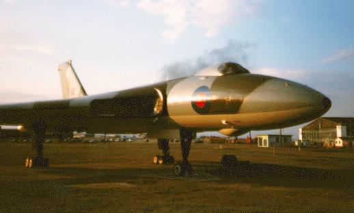
Vulcan Bomber, Goose Bay: The Royal Air Force trained its Vulcan Bomber pilots out of Goose Bay during the 1970s. After the training program was discontinued, a Vulcan was placed on permanent static display near the passenger terminal at Goose Bay Airport. It is one of two static aircraft displays in Happy Valley-Goose Bay, which are monuments to the town's rich military aviation heritage.
Three smaller communities are located near Goose Bay, and are favourite daytrip destinations. Mud Lake is on the south side of the Churchill River, just a few miles east of Happy Valley. It is a beautiful village of roughly 100 people which has maintained its early 20th century charm. A lazy channel separates the community into an island and mainland part, with homesteads and the landmark wooden church lining both the channel's banks. The remains of turn-of-the-century lumber mills can still be seen along the shore, a reminder of the industry which first drew people to settle here in large numbers 100 years ago.
Forty kilometers away by paved highway are Sheshatshit and North West River. Sheshatshit is the larger of two Innu communities in Labrador. The majority of its roughly 1000 inhabitants are Innu, descendents of a people that have been in Labrador for some 6000 years. Sheshatshit was only permanently settled during the 1950s; prior to this the Innu maintained a largely nomadic existence, living off the land in different localities depending on the season.
Across the river from Sheshatshit is North West River. Founded as a trading post by Louis Fornel from New France in 1763, it is located on a peninsula surrounded on three sides by water. During the 19th century it was an important Hudson's Bay Company post. The main street, known as The Portage, was built in the 1850s by Donald Smith, the Company's officer in charge. Smith, later Lord Strathcona, became an important Canadian statesman and politician, playing a role in combatting the Red River Rebellion, serving in the cabinet of Sir John A. MacDonald, and celebrated as the man who drove the Last Spike in the national railway. The Portage ends at North West River's mile-long sandy beach. This is literally the end of the road, and during the summer, the warm, shallow waters are a favourite place to relax.
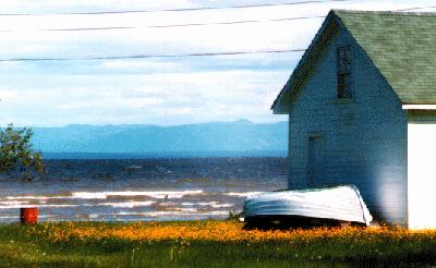
'Striver Beach: Tidy houses line the beach at North West Riveró'Striver as it is often called in the "efficient" North West River dialect! A mile of silvery-gray sand, with warm shallow waters, and a beautiful view of Lake Melville and the distant Mealy Mountains, this is the site for the annual 'Striver Beach Festival, held in late July.
![[MAIN]](main.gif)
![[NORTH]](north.gif)
![[SOUTH]](south.gif)
![[HISTORY]](hist.gif)
![[NATURE TRAIL]](wild.gif)
![[LABRADOR LINKS]](links.gif)
![[MAIL FOR INFO]](info.gif)
This page hosted by 
Get your own Free Home Page


![[MAIN]](main.gif)
![[NORTH]](north.gif)
![[SOUTH]](south.gif)
![[HISTORY]](hist.gif)
![[NATURE TRAIL]](wild.gif)
![[LABRADOR LINKS]](links.gif)
![[MAIL FOR INFO]](info.gif)