|
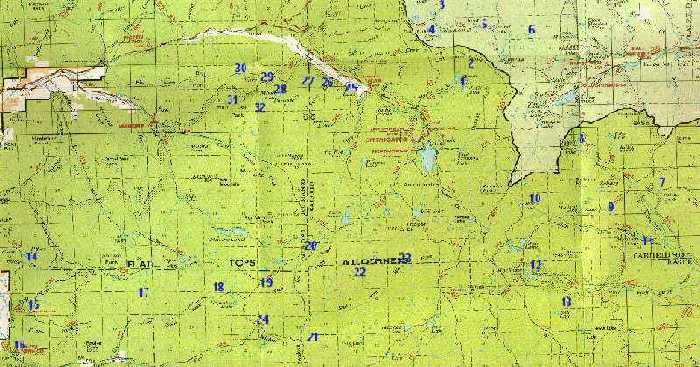
Big Game Hunting Locations in ColoradoFlat Tops WildernessBig Game Hunting Unit(s): 24, 25, and 26.How To Get There:The Flat Tops Wilderness covers an extremely large area. As a result, the locations identified here are widely dispersed. I have listed four different routes to them.To get to the first area take Interstate 70 west from Denver to Rifle (approximately 150 miles). Then take Highway 13 north to Meeker. From Meeker take Road 8 through Buford driving along the White River up to Trapper's Lake. To get to the second area you also take I-70 west to Rifle. From Rifle head north on Highway 13 to Meeker. Next take Road 8 to about a mile before the Buford exit. You will then turn and head southwest along the south fork of the White River. It will take you up into the Stillwater Valley. To get to the third area take I-70 west to Dotsero (approximately 130 miles), then turn north on Colorado River Road and drive to Burns. From there take Road 10 northeast to the areas marked on the map. To get to the fourth area take I-70 west to Highway 40 then north to the town of Kremmling. North ot Kremmling you will turn left on Road 15 and shortly thereafter turn left on Road 13. Follow Road 13 1.7 miles to a 4x4 road that will branch off to the left. This is the South Hunt Creek Road which you will follow until it ends. How To Hunt The Flat TopsThe Flat Tops were named for a paticular topography where a steep high mountain flattens out on top, forming large high altitude table. There are a few peaks rising out of the flat upper table, but generally, the land is very flat. A lot of the country does look the same which is why so many people get lost up there. To avoid that trauma, pick out a landmark from which you can always get your bearings. This entire area has a four point restriction. There has been a development of a truly incredible trophy hunting opportunity. This country provides some of the best close cover hunting anywhere. The vegetation consists of aspen and spruce stands, small parks, meadows, and heavy dark spruce pockets (known as dark timber) with a lot of blowdowns. The downed timber limits game travel to trails which makes them easy to locate and ambush. If a storm is coming in and barometric pressure is rising, you can hunt along game trails all day long. The animals will be moving about in anticipation of the storm, rather than bedding down like they usually do during the middle part of the day.
 Colorado Hunting Locations 
 Spot B - Oak Creek & Dunckley Pass Spot B - Oak Creek & Dunckley Pass
|


