|
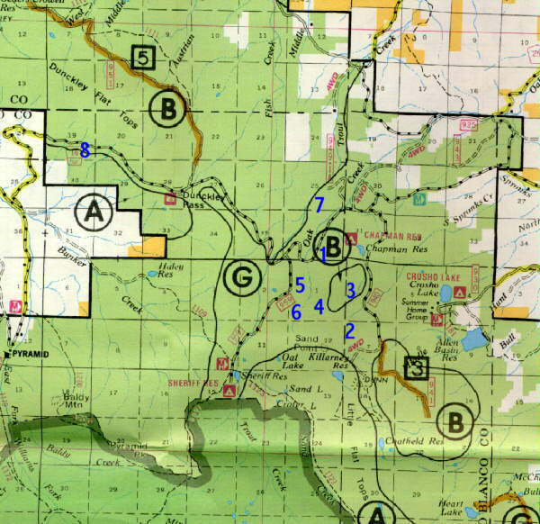
Big Game Hunting Locations in ColoradoOak Creek & Dunckley PassBig Game Hunting Unit(s): 231, 12.How To Get There:From Kremmling go west on Highway 134 across Gore Pass. On the other side take Highway 131 to the town of Yampa. Then take Fire Road 17 west to the spots indicated on th map.How To Hunt This AreaMuch of this area can best be described as "wet." There is a lot of water on the hillsides below the flat top cliffs, and in the creek bottoms. Those spots are so wet, that when a tree reaches a certain size, it can not support its own weight and falls over. The result is a lot of lush green vegetation with thick mosses and ferns growing between downed timber. The ridges above the wet spots are drier. However, all of the game activity focuses on the wet spots and the food they provide.
 SPOT 01: Upper Branch of Oak CreekJust to the east of the spot where the west branch of upper Oak Creek intersects the road is a patch of dark timber 50 yards off the road. There are actually elk in there even though it's right next to the road. They cross the road and feed in the meadows along Oak Creek at night, then return to the timber by morning. Be aware of black bear that are also in the area.SPOT 02: Crossroads WaterholeTake Road 940 south toward Dunns Peak. There will be some logging roads branching off this road to the west which you can walk up. The very last logging road will take you toward the base of Sands Peak. Walking up the road you'll come to a place where several other older logging roads intersect. Right at the intersection is a waterhole that is full part of the year. Unlike the valleys below, the ridge you're on is dry except for that waterhole. Elk moving down from Sands Peak water there.SPOT 03: Downhill SpringsDrive up Road 940 south towards Dunns Peak. Take the second gated road to your right, an walk west. On the downhill side of the road are springs that support a lot of green foliage, while the surrounding foliage is pretty dry. Look for elk in those spots.SPOT 04: Sand PointDirectly below Sand Point to the north is a flat spot that runs east and west along the base of the point. Elk move along the base preferring the flat thoroughfare to the steeper slope above.SPOT 05: Deer TrailsFollow the west branch of Oak Creek up from where it crosses Fire Road 16. You'll find dark pines to your right crisscrossed with large deer trails. In some spots, the dear trails are at least 4 feet wide and heavily used. Farther up, the terrain will open to a very large meadow.SPOT 06: Marshy HillsidesDirectly below Sand Point and above the meadow mentioned in the previous spot are a lot of very marshy meadows and lakes which form the headwaters of the upper west branch of Oak Creek. To get there walk up from the spot where the west branch of Oak Creek crosses Road 16. All the thick underbrush severely limits visibility but supports many elk.SPOT 07: Between Oak & Trout CreeksWalk the fields north of Fire Road 16 between Oak and Trout Creeks. They're good places to hunt during the late rifle seasons providing the snow has pushed the elk down.SPOT 08: Southwest of Dunckley Flat TopsThis place is not very easy to get to, but it is great for dear. Unfortunately the easiest access has been blocked off because a couple of hundred yards of it crosses private property. To get there cross Dunckley Pass heading west. One mile before the road makes a sharp U-turn and heads downhill, park where you can. There are no pulloffs. Start from the top. You will have to cut down through some small cliffs. The woods below are full of deer. Colorado Hunting Locations 
|


