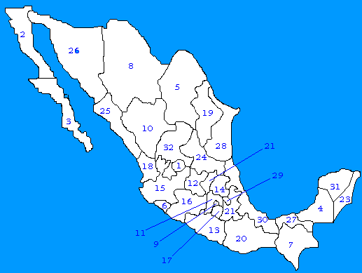
 México has a total surface of 1,958,200 square kilometers, what makes it the 9th biggest country in the world. The current population is 91,840,000 people (Mexicans).
The territory is divided between 31 States and a Federal District:
| Number |
State |
Capital City |
Surface |
| 1 | Aguascalientes | Aguascalientes | 5,589 sq. km. |
| 2 | Baja California | Mexicali |
| 3 | Baja California Sur | La Paz |
| 4 | Campeche | Campeche | 56,114 sq. km. |
| 5 | Coahuila | Torreon | 149,982 sq. km. |
| 6 | Colima | Colima | 5,191 sq. km. |
| 7 | Chiapas | Tuxtla Gutierrez | 74,211 sq. km. |
| 8 | Chihuahua | Chihuahua | 244,938 sq. km. |
| 9 | Distrito Federal | Mexico City | 1,479 sq. km. |
| 10 | Durango | Durango | 123,181 sq. km. |
| 11 | Estado de México | Toluca | 21,355 sq. km. |
| 12 | Guanajuato | Guanajuato | 30,491 sq. km. |
| 13 | Guerrero | Chilpancingo | 64,281 sq. km. |
| 14 | Hidalgo | Pachuca | 20,813 sq. km. |
| 15 | Jalisco | Guadalajara | 80,137 sq. km. |
| 16 | Michoacan | Morelia | 59,928 sq. km. |
| 17 | Morelos | Cuernavaca | 4,950 sq. km. |
| 18 | Nayarit | Tepic | 26,979 sq. km. |
| 19 | Nuevo León | Monterrey | 64,924 sq. km. |
| 20 | Oaxaca | Oaxaca | 93,952 sq. km. |
| 21 | Puebla | Puebla | 33,902 sq. km. |
| 22 | Queretaro | Queretaro | 11,769 sq. km. |
| 23 | Quitana Roo | Quintana Roo | 50,212 sq. km. |
| 24 | San Luis Potosí | San Luis Potosí | 63,068 sq. km. |
| 25 | Sinaloa | Culiacán | 58,328 sq. km. |
| 26 | Sonora | Hermosillo | 184,934 sq. km. |
| 27 | Tabasco | Villahermosa | 25,267 sq. km. |
| 28 | Tamaulipas | Ciudad Victoria | 79,384 sq. km. |
| 29 | Tlaxcala | Tlaxcala | 4,016 sq. km. |
| 30 | Veracruz | Jalapa | 71,679 sq. km. |
| 31 | Yucatán | Merida | 38,402 sq. km. |
| 32 | Zacatecas | Zacatecas | 73,252 sq. km. |
Each state has its own Government and is independent from the Federal Government.
 Back to Home Page
This page hosted by
 get your own Free Home Page


 Back to Home Page