| The day before sailing to the Ha'apai group, TETHYS
joined seven other boats (CATAFUN, INGRID, JUBILEUM, LOAFER, PENELOPE, SARANDANE,
and TUCUMCARI ) at the southernmost anchorage of the Vava'u group, taking
shelter from strong east winds behind a small island offering minimal protection. We all
planned to leave very early in the morning to sail the 60 odd miles during daylight hours.
TUCUMCARI was first to leave at 0200 followed by others at intervals
throughout the pre-dawn hours. We left at about 0400 and nervously negotiated the first
five miles around several small islets and shoal areas using the GPS and Radar. One of the
most nerve wracking departures we ever had according to Paula who sat glued to the depth
sounder the whole way. |
| By first light we were sailing close hauled under
double reefed main and staysail, doing 5.5 knots, taking waves over the bow, and pounding
into the confused short six foot seas. The wind was averaging better than 20 knots with
gusts over 30, and by 0800 Vlad was seasick. This is the first time since leaving
Vancouver that the motion sickness pills and ginger did not work. Able seaman Paula stood
a very long watch (6 hours) while delicate Vlad succumbed to mal de mer. |
| Finally, as we came into the lee
of Ha'ano island the seas calmed down, the motion of the boat became more comfortable and
Vlad emerged in time to spot a humpback whale slapping its huge flippers on the water. We
took that as a sign of special welcome to TETHYS and crew for surviving
the trip. Friends on TUCUMCARI saw a whale breech several times as they
approached the island. |
| As the anchorage at Ha'ano
looked very rolly, most of the boats (who were all ahead of us) decided to continue to
Foa, 4 miles further. However, when TUCUMCARI arrived at Foa island, and
reported passing over a rope just under the water between two buoys when going through the
reef pass, the fleet decided to continue another five miles to the anchorage off Pangai on
Lifuka. The rather tired crew aboard TETHYS checked out the Foa situation
and found an alternate anchorage through a marked channel. It was with much relief that we
set the hook and settled down for dinner and early bed. We had got very wet on the trip
down and our hair was full of salt so next day (which was Vlads birthday) started with
much needed showers and a leisurely breakfast. |
| With the exception of Tongatapu
(which has deep sea vessels entering the port of Nuku'alofa) charts of the Tongan
archipelago are based on surveys done by the British navy at the end of the 19th
century. Since then coral reefs have grown, earthquakes have changed the bottom profile in
places, and the sea has eroded some low lying features. We acquired copies of some detail
charts, a small photo copied cruising guide for Ha'apai with sketches of the main
anchorages, and electronic charts to help us avoid the underwater dangers. The electronic
charts proved to be the most useful when planning the short passages between anchorages.
We set our route waypoints on the computer screen, printed the chartlets on our colour
printer, and programmed the GPS to keep track of our position as we sailed or motored
among the islands and reefs. We timed our travels with the sun above and behind us to be
able to clearly see the shoals and reefs. The water is very clear for the most part and
the obstacles are visible quite a distance away as long as the sun cooperates. |
 |
There are villages on most of the larger islands where the locals
survive by farming and fishing. Pangai is the largest town and the governing center of
Ha'apai. The king of Tonga has a palace in Pangai, there is one bank, several very small
food shops, a hardware store, one restaurant, and four churches. There are also several
very small resorts on Lifuka and Foa islands. We rented bicycles together with Bob and Cyn
of TUCUMCARI and cycled along the main road of Lifuka, over the causeway
to Foa, and had a picnic lunch on the beach at the end of the road on the eastern point of
Foa. The level of agriculture on this island surprised us as we had been expecting
something similar to the Tuamotus. But Tonga gets a lot more rain and so we saw large
plantations of taro, tapioca, papaya, tomatoes, pineapples, cabbages and even corn. |
|
| We attempted to visit some of the archeological sites
but were unsuccessful because of the heavy undergrowth. There has been little
archeological investigation in Tonga because Tongans are (quite naturally) opposed to the
digging up of burial sites. Since maintenance of graves is a family responsibility, if the
family dies out, they go uncared for. The old burial site on Lifuka is consequently quite
overgrown with scratchy brambles and bushes. Modern burial sites in Tonga are rather
interesting. The custom seems to be to build a large sand mound, in which (we presume) the
coffin is buried. The grave site is covered with (usually artificial) flowers and often a
homemade banner the size and form of a quilt, is raised over the grave. This is then left
until it falls apart in the weather. A Tongan in mourning wears the traditional ta'ovala
or woven pandanus skirt for about a year after the death. These are also worn on formal
occasions. |
| The winds picked up strength again from north of east
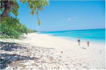
so we took shelter behind Uoleva island and reef for a couple days. There is a lovely deep
sand beach on this uninhabited island, but that same deep sand beach is a warning that a
westerly wind causes big waves here, so when the weather forecast called for westerlies we
thought it prudent to move to an anchorage that would protect us from the western quarter.
This is hard to do in the Ha'apai group since most islands are completely exposed to wind
and waves on their west sides. The fleet decided to move to the east side of Ha'afeva
Island, which lies about twenty miles west of Uoleva and which is protected from
west wind and waves by a reef, and from the north and east by the island. The day was
squally and the visibility in the rain poor. We had to use the radar to get us past the
end of the reef into the anchorage at Ha'afeva! The predicted westerlies turned out to be
quite light, so the fleet broke up with several boats leaving for Tongatapu in the south
and others moving to the west side of Ha'afeva. Most of the days were spent
snorkeling, shelling along the sand beaches, exploring the village, fishing, reading, and
socializing with other cruisers. |
| From the new wharf on the west
side of the island, a road leads straight across to the village. It is a good road, made
of coral, and goes through plantations of tapioca, taro, papaya, breadfruit and bananas.
The island’s produce is mainly sold in the market at Nuku’alofa. On this island,
the plantation area is cut off from the village by a fence which goes all the way round
the village and even down to the beach and into the water. This fence keeps the pigs,
which roam freely in the village, out of the plantations. The village area is brown and
scrubby from the rooting around of the pigs. The occasional goat and horse are kept tied
up for the most part and we did not see many chickens here, but there are certainly a lot
more pigs than people. |
| We found a small store in the
village with chocolate chip cookies but no bread so we bought flour from a big plastic
barrel to make our own. There are also four churches – Mormon, Wesleyan, Tongan and
Catholic. The Mormon church has a basketball court of course. We found out later, talking
to a Mormon missionary (from Las Vegas!) that almost no one plays basketball, although the
island girls use the court for netball. It seems to us that a rugby or cricket pitch
would make more sense in Tonga. |
| After a few days at Ha'afeva we moved to Oua and
anchored in the lagoon behind substantial reefs. The weather had calmed down with very
little wind and lots of sunshine. Unfortunately the water in the Oua lagoon is murky and
so we stayed only the one night. |
| From Oua we motored to the twin islands of Nomuka and
Nomuka Iki about 15 miles further south. Nomuka Iki used to have a prison, however there
is little left of the facilities. A Nomuka islander is farming part of the island and
harvesting bananas, papaya and coconuts. Otherwise Nomuka Iki is uninhabited, except for a
few wild goats. It is overgrown with brush and coconut trees, surrounded by a reef and
sand beach. Together with Larry and Lena of ALLONS'Y, we walked the
beach, scrambled along a stretch of ledges on one side, and waded about 100 feet through
surf to circumnavigate the island on foot. Our rule is to do only one activity per day, so
the rest of the afternoon was spent snoozing and reading. |
| The winds shifted every day and we were forced to change
anchorages to find protection behind reefs and either Nomuka and Nomuka Iki. However there
were also periods of sunshine and calm. We had a communal garbage burn on the beach one
evening, standing around, drinks in hand, discussing local cruiser gossip, while the fire
slowly consumed a variety of ordure. We prefer to burn garbage on a beach instead of
placing it in the local village garbage cans for fear that it will end up floating in the
sea. Cans and glass we keep until we are in deep water and then sink them.The Nomuka
villagers handle their pigs somewhat differently from Ha'afeva. Pigs roam freely in the
village but almost all the houses have fenced yards and nice gardens. There is a cattle
grid on the coral and dirt road into the plantation area, but there does not seem to be
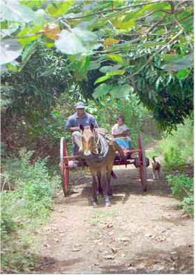
the same level of agriculture here as on Ha'afeva or Lifuka. There are no trucks on this
island, so the islanders still use horse and cart to transport themselves and produce
across the island. Horses seemed to us to be quite sensible as a truck would require
imported diesel and spare parts, whereas a horse can be fed on locally grown grass and
will reproduce as well! However, the horses are a bit on the thin side. |

|
| For several days we anxiously followed the progress of
friends on their passage to New Zealand. Two Canadian boats, ASTROLABE
and SIRI, together with U.S. boats PHANTOM and ARAHINA,
left Nuku'alofa with not the best weather prognosis for the passage. They spent several
days hove to waiting for a low pressure system to pass south of them. The pesky low
stalled for three days and our friends drifted north and west instead of making progress
south towards New Zealand. SIRI carried on south, but in strong winds and
large seas, and arrived in New Zealand three days ahead of the others. We are studying
weather faxes everyday hoping to determine the best weather patterns and avoid a similar
situation. |
| On October 25, we left Nomuka at first light and had a
great sail to Nuku'alofa on Tongatapu
Island. |

