When we cruised these same waters in 1993, Buckle Harbor was a quiet little cove, which we often had to ourselves. However, on this night, we counted 14 boats at anchor in the tiny harbor. It felt more like being in a much-used city park than the wilds of Maine.
The next day, we motored out the winding passage north of Buckle Harbor, and raised the sails, not so much with a destination as a general direction in mind. Again we beat into variable winds that gradually filled in from the southwest, becoming quite boisterous as we reached the channel called Merchant's Row. When the wind reached the point that it was time to reduce sail, we decided to duck in behind a nearby island instead of expending the effort of putting in a reef and continuing on. We spent that night in the slightly rolly Merchant Harbor.
Cathy contemplates Maine's beauty
 After
a night that was made less restful than we had hoped by the roll of
swells into the harbor, we motored across East Penobscot Bay, just
making out the islands through the fog, and bracing against the
uncomfortable swell that rolled up the bay from the open
Atlantic. We entered Winter Harbor (one of the many so named) on
Vinalhaven Island at half tide, and as the tide continued to rise, we
wound through the passages between the rocks and ledges that pepper
this Harbor. Winter Harbor is a very long and narrow slit in the
eastern side of Vinalhaven Island, shaped on the chart as if someone
had thrust a knife deep into the side of the island, and then removed
it for the sea to pour in. The rocks seem to have been placed
strategically in ever-narrowing gates, in just such a way as to form a
series of progressively smaller anchorages. For the timid sailor,
the outer harbor has but one rock to negotiate, and that is well off to
the side. Those more confident, or perhaps foolish, press on past
the second set of rocks, or even the third. With Cathy at the bow
scouting for rocks, we wound our way through and dropped our Bruce
anchor in the fourth such anchorage, next to a small, disused
production sailboat on a mooring. Later that evening another
boat, hoping that the very height of the 12 foot tide would lift them
above the submerged dangers, bumped his way over the ledges and into
the anchorage near us.
After
a night that was made less restful than we had hoped by the roll of
swells into the harbor, we motored across East Penobscot Bay, just
making out the islands through the fog, and bracing against the
uncomfortable swell that rolled up the bay from the open
Atlantic. We entered Winter Harbor (one of the many so named) on
Vinalhaven Island at half tide, and as the tide continued to rise, we
wound through the passages between the rocks and ledges that pepper
this Harbor. Winter Harbor is a very long and narrow slit in the
eastern side of Vinalhaven Island, shaped on the chart as if someone
had thrust a knife deep into the side of the island, and then removed
it for the sea to pour in. The rocks seem to have been placed
strategically in ever-narrowing gates, in just such a way as to form a
series of progressively smaller anchorages. For the timid sailor,
the outer harbor has but one rock to negotiate, and that is well off to
the side. Those more confident, or perhaps foolish, press on past
the second set of rocks, or even the third. With Cathy at the bow
scouting for rocks, we wound our way through and dropped our Bruce
anchor in the fourth such anchorage, next to a small, disused
production sailboat on a mooring. Later that evening another
boat, hoping that the very height of the 12 foot tide would lift them
above the submerged dangers, bumped his way over the ledges and into
the anchorage near us.The next day we watched a small trimaran, requiring only inches of water to float, sail past us up the harbor and out of sight around a wall of trees and rocks further in. We decided to explore behind them, but thought the dinghy would better serve the purpose than Sovereign herself. We found the trimaran anchored in the churning water at the base of what might be described as something between a mill race and a waterfall. As each eddy and whirlpool formed and swirled past, the trimaran whirled and danced, swinging wildly back and forth. The "crew" of the trimaran (made up mostly of very young and clearly delighted boys) were using the area as a natural water park, splashing and playing in the swift current. The skipper of the trimaran, seeing us holding position a safe distance off their gyrating boat, told us the race was plenty deep, and we could proceed to the upper pool in the dinghy. Waiting for an opening made by a swing of their boat, we scooted by, and then gunned the outboard to take us up the hill of swiftly moving water. It was exciting, but not nearly as much as the ride back after exploring the upper pool, when the speed of our dinghy was added to the considerable speed of the water rushing through the gap.
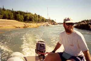
Dinghying through the mill race, Winter Harbor
 After
returning to the boat for lunch, we took the dinghy ashore, and
hitchhiked the few miles into town. Cathy was a little concerned,
this being her first attempt at thumb-assisted transportation.
After a few assurances on my part, we rode into town with a summer
resident of more than 25 years. In town, we searched the cemetery
for evidence of some of my ancestors who, according to my mother, had
lived on Vinalhaven. Without much original information to go on,
the most we could do was look through the cemeteries for those with the
correct surnames, and take down the information from the
headstones. We hitched back to the boat with a man and his three
children who had a summer house on a cliff overlooking Winter Harbor.
After
returning to the boat for lunch, we took the dinghy ashore, and
hitchhiked the few miles into town. Cathy was a little concerned,
this being her first attempt at thumb-assisted transportation.
After a few assurances on my part, we rode into town with a summer
resident of more than 25 years. In town, we searched the cemetery
for evidence of some of my ancestors who, according to my mother, had
lived on Vinalhaven. Without much original information to go on,
the most we could do was look through the cemeteries for those with the
correct surnames, and take down the information from the
headstones. We hitched back to the boat with a man and his three
children who had a summer house on a cliff overlooking Winter Harbor.The next day, a Friday, we raised anchor and, keeping a careful lookout for the same rocks we had dodged on the way in, exited the harbor. We motored up through the passage--called Fox Island Thorofare--which runs between Vinalhaven and the slightly smaller island of North Haven. (Collectively these two larger islands and the many smaller ones that surround them are called the Fox Islands, hence the name of the passage.) We anchored in a well protected cove called Perry Creek, just off the Thorofare. After we were certain the anchor was well set, we dinghied ashore to the town of North Haven for a stretch of legs and to see the sights.
The next morning, we took the dinghy further up Perry Creek. The further in we went, the more beautiful it became. In the afternoon ,we motored to Pulpit Harbor, on the northwest side of North Haven. We spent the rest of Saturday, and all of Sunday in Cabot Cove of Pulpit Harbor, mostly alone except for the moored boats of the locals. We had also stayed here in 1993, and we were pleased to see that it had not changed at all. With the luxury of some free time, Cathy tried her hand at cutting my hair and beard, and I reciprocated by trimming her bangs and the ends of her hair. (I think I got the better deal, as she had to correct her bangs herself, while my hair was just right.)
On Monday, August 23, we raised anchor, motored out the harbor, and set a southerly course skirting the western shores of North Haven and Vinalhaven to Green Island, at the southwest corner of Vinalhaven. A boat arriving at the same time as us got the only spot available for anchoring, but one of the locals who happened to be passing in a skiff directed us to an unused mooring, which we picked up.
Vinalhaven, home of 6 generations of Jim's ancestors
 For
the next two days, armed with a little more detailed information from
my mother and my uncle, we dinghied into the town of Vinalhaven and
visited the Vinalhaven Historical Society. The Society's building
is a small, white, one room clapboard house at the top of a steep hill
above the harbor. In addition to the artifacts and photographs
which one would expect at a small museum, they also had volumes and
volumes of extracts of U.S. Census and Town Clerk records. We
pored through these books for two days looking for the sparse evidence
of the history of my ancestors in coastal Maine. We were able to
find good information on six generations of fishermen and a ship
captain who had lived in the Fox Islands, and once we had found an
ancestor that someone else had already done the work for, their
computer supplied information going back 12 generations. We were
tired from long hours of poring through the minutiae of births and
deaths, but were pleased to have pulled a little on this formerly
elusive thread of our family history.
For
the next two days, armed with a little more detailed information from
my mother and my uncle, we dinghied into the town of Vinalhaven and
visited the Vinalhaven Historical Society. The Society's building
is a small, white, one room clapboard house at the top of a steep hill
above the harbor. In addition to the artifacts and photographs
which one would expect at a small museum, they also had volumes and
volumes of extracts of U.S. Census and Town Clerk records. We
pored through these books for two days looking for the sparse evidence
of the history of my ancestors in coastal Maine. We were able to
find good information on six generations of fishermen and a ship
captain who had lived in the Fox Islands, and once we had found an
ancestor that someone else had already done the work for, their
computer supplied information going back 12 generations. We were
tired from long hours of poring through the minutiae of births and
deaths, but were pleased to have pulled a little on this formerly
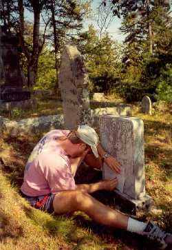
elusive thread of our family history.Etching the gravestone of my great-great-grandmother
 The
next morning, August 25th, we slipped our mooring at Green Island, and
motored out the harbor. The visibility across the water from
Green Island to Vinalhaven was deceptive; by the time we were 100 yards
out of the harbor the fog closed in thickly with perhaps 30 yards
visibility. The whole area of the Fox Islands is strewn with
rocks, ledges, and islands, which are well marked by buoys, but are
never the less invisible in the fog. Having plotted and noted the
distances and bearings between all the buoys along our course in
advance, however, it was just a matter of playing "connect the
dots": 0.4 miles at a course of 103 degrees magnetic, then 0.6
miles at 096 degrees magnetic, and so on through a long string of
courses and distances. Cathy was also on the bow to spot the
buoys as well as listen for other boats. Our traditional
navigation was supplemented with our GPS satellite navigator and radar,
"just in case", but in essence it was the same methods as those used
for centuries by my ancestors along that very coast. Once out
into the open waters of East Penobscot Bay, and still with dense fog,
we raised the sails and ran straight downwind up the bay, never seeing
anything but the gray fog, the water, and the occasional lobster buoy
passing by. Fog has the capacity to free the mind by obscuring
the details of sensory perception, and we were free to imagine that we
were, in fact, sailing up the bay in company with one or another of
those whose names we had been reading in books of the Census. As
sometimes happens, as we approached our anchorage at Northwest Harbor
for the night, the relatively warmer air passing over the land mass of
Deer Isle lifted the fog over the harbor, and we entered without
difficulty.
The
next morning, August 25th, we slipped our mooring at Green Island, and
motored out the harbor. The visibility across the water from
Green Island to Vinalhaven was deceptive; by the time we were 100 yards
out of the harbor the fog closed in thickly with perhaps 30 yards
visibility. The whole area of the Fox Islands is strewn with
rocks, ledges, and islands, which are well marked by buoys, but are
never the less invisible in the fog. Having plotted and noted the
distances and bearings between all the buoys along our course in
advance, however, it was just a matter of playing "connect the
dots": 0.4 miles at a course of 103 degrees magnetic, then 0.6
miles at 096 degrees magnetic, and so on through a long string of
courses and distances. Cathy was also on the bow to spot the
buoys as well as listen for other boats. Our traditional
navigation was supplemented with our GPS satellite navigator and radar,
"just in case", but in essence it was the same methods as those used
for centuries by my ancestors along that very coast. Once out
into the open waters of East Penobscot Bay, and still with dense fog,
we raised the sails and ran straight downwind up the bay, never seeing
anything but the gray fog, the water, and the occasional lobster buoy
passing by. Fog has the capacity to free the mind by obscuring
the details of sensory perception, and we were free to imagine that we
were, in fact, sailing up the bay in company with one or another of
those whose names we had been reading in books of the Census. As
sometimes happens, as we approached our anchorage at Northwest Harbor
for the night, the relatively warmer air passing over the land mass of
Deer Isle lifted the fog over the harbor, and we entered without
difficulty.The next day, and the last of this little cruise, we exited Northwest Harbor, and again in very thick fog, we steered by compass and log (with the help of GPS and radar, too, and Cathy on the bow) through the gauntlet of small isles that guard the western approach to Eggemoggin Reach. Once in the Reach, with land on either side, the fog lifted, the wind perked up, and we raised the sails. While the Reach started out true to its name (meaning that the wind was approximately on the beam, an easy point of sail) it quickly turned into a drift as the wind died. We eventually gave up and started the engine. We motored up the "reach" and through an area where the wind quickly built and funneled from straight ahead of us. Motoring through the twisting passage north of Buckle Harbor, we happened to pass a boat high and dry on the rocks that had apparently not been so fortunate with the fog as we had been. They already had help on hand, so we continued through the passage, and then raised the sails for the last of the trip around the southern tip of Mt. Desert Island.
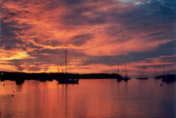
We started the engine as the wind died once again, and motored up Western Way and into Southwest Harbor. Just as the sun set and darkness filled in, we picked up a mooring that had been offered to us by a friendly couple with a summer house on the harbor. As the pinks and purples of sunset gave way to the grays and blacks of dusk, we had time to reflect on a journey which, though less than a hundred miles on the ship's log, was a much greater journey into the waters, lands, and lives of those generations of fishermen and sea captains whose histories we had unearthed in a little white clapboard building on a little island off the coast of Maine.
Southwest Harbor
