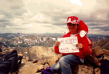

At 14,433 feet, Mt. Elbert is Colorado's highest peak, rising above the upper Arkansas Valley. It lies just east of the Continental Divide in the Sawatch Range. The first documented climb of Mt. Elbert was in 1874; we didn't manage to make it up until August 7, 1993. Klaus climbed it again, solo, on August 6, 2002.
There are many approaches to the summit, most taking advantage of Elbert's long, gently sloping ridges. The easiest follows Elbert's notheast ridge, beginning from Halfmoon Creek, which trickles between Mt. Elbert and Mt. Massive. As Colorado's highest mountain, this trail is very popular, though, and you are likely to encounter many people along the way.
Our favorite approach is from the south, along the Black Cloud Trail. To find the trail, take Colordao Highway 82 west from US 24; drive through the town of Twin Lakes, continuing west until you reach the Mt. Elbert Lodge (about half way to Independence Pass). Just to the east of the Lodge there is a sign along the highway which marks the trail. If you can't find it, just ask at the lodge.
This trail begins at 9,689 feet and starts out somewhat steep, but nothing you can't handle, following Black Cloud Creek. At about 10,840 feet, you'll cross the creek to the west and the land levels out quite a bit. Not long after you cross the creek, the trail will split in two at an unmarked junction. Take the left hand trail - the right hand trail (the one which goes more or less straight ahead) leads to the base of a cirque.
Follow the left hand trail as it steadily rises, cutting back and forth as it hits the steeper portions. Keep on the lookout for ptarmigans during this phase. Better look now, because they're a lot harder to see when you get above timberline because they blend in so well with the rocks.
Just as you come out of the trees just below timberline (12,000 feet) you will find an old mining cabin. This is a great place to sit down, have an orange and gaze to Twin Peaks across the valley you have just hiked. If the weather is really clear, you can see Pike's Peak to the southeast in the far distance.
Follow the trail southeast up to the the ridge, then follow the ridge to the north. At about 12,800 feet you'll have to traverse to the west to the remains of Fidelity Mine. To the south, you can now see La Plata Peak (Colorado's fifth highest at 14,361 feet) on the other side of Lake Creek.
 Continue
uphill just 950 more feet (up) and you'll come to the summit of Colorado's highest
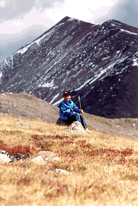
"hill," Bull Hill. From here you have a beautiful view of Mt. Elbert to the
northeast. You don't need directions from us from this point on - just follow the ridges
to the summit. It's pretty obvious (as you can see in the picture to the right).
Once at the summit, you'll run into the many people who have ascended Elbert from Halfmoon Creek. You, on the other hand, probably haven't encountered anybody since you crossed Black Cloud Creek! Well, maybe one or two other parties.
Needless to say, the view from here is tremendous. That's the Mosquito Range if you look east across the Arkansas River. Just to the north, is Mt. Massive, Colorado's second highest mountain. To the west is the Elk Range.
All in all, the hike is about five miles for about 4,700 feet in elevation, and, of course, about five miles back down if you go the same route. It's a long hike if you're nine, as Klaus was when we finally made it to the summit. But even if you only make it to the top of Bull Hill, it's well worth the effort.
This page hosted by ![]() Get your own Free Home Page
Get your own Free Home Page