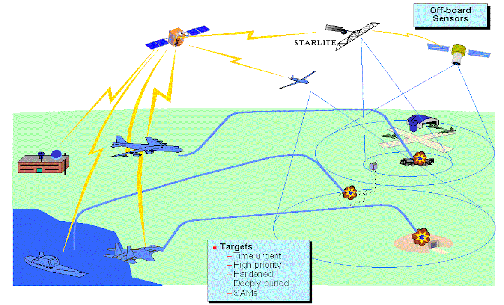
This graphic was not provided with the press release but illustrates
possible satellite communications functions.
NRO Provides Support to the Warfighters
28 April 1998
"Sabre One, this is the CAOC, we have an armored
column in your area.
We're downloading video feed of location."
"Roger CAOC. We have it."
The F-15E Strike Eagle turns and steers to the
coordinates provided--
the pilot uses pictures being provided to the
cockpit to find the targets.
The ranks run, but they can't hide from the overhead
Predator
reconnaissance aircraft, which feeds pictures
to the F-15 via the
Combined Air Operations Center. Using these pictures,
the crew find
the tanks within minutes and destroy them using
laser guided bombs.
Direct TV to the cockpit? It may not be like turning
on the game at
home, but it's not science fiction any more.
Today, due to a joint
effort between the Air Force, Navy and the National
Reconnaissance Office, targeting footage is provided
directly to the
cockpits of Air Force F-15Es and Navy F/A-18s
operating in Bosnia.
The Rapid Targeting Capability has been in Bosnia
since Sept. 1996.
The key players in developing the system were
the NRO, the Air
Force's Reconnaissance Program office at Wright
Patterson AFB,
Ohio and the Naval Air Warfare Center at China
Lake. The system is
primarily designed for aircraft going after mobile
targets that aircrews
operating on alert haven't had the opportunity
to preplan.
The Rapid Targeting Capability can take video
or
images from platforms like the unmanned Predator,
the U-2 or the Joint
Stars and transpose it over an NRO satellite
photo and then match the
two in realtime to get precise target coordinates.
The satellite photo
provides a broad area context for the smaller
snapshot from the tactical
reconnaissance aircraft and provides more precise
coordinates than can
be provided from the tactical feed alone.

"We provide television to the cockpit to put bombs
on target," said Maj.
Alan Tucker, one of the NRO's engineers who helped
develop the system.
The process may start with a ten by ten nautical
mile pictures of the target
fed to the cockpit, improved by five by five,
then to one by one and finally
down to a view that provides the same heading
as the approaching aircraft.
These different pictures give the pilot a perspective
he wouldn't get from a
tactical aircraft alone and aids him in finding
the target.
Before this system was in place an aircraft might
be vectored to its target by
a forward air controller - a process that often
required the aircraft to orbit
over a target area for as much as 15 minutes.
"This doesn't take any more than five minutes
over the target area," said
Major Stephen Schwartz, an F-15E pilot with the
334th Fighter Squadron at
Seymour-Johnson AFB, N.C. Schwartz used the
system while deployed to Bosnia with the 49th
Fighter Squadron out of
RAF Lakenheath. "It's safer for us because we
don't have to orbit nearly
as long and it's safer for the FAC because he
doesn't have to be there
at all."
Ideally the pilot may never have to overfly the
target area at all. During testing at Nellis
AFB, Nev, Aircrews used the
system to go straight to targets and launch while
still 4-6 miles away,
according to Lt. Col. Bob Halverson, the operations
officer for the 4th
Training Squadron at Seymour-Jouhnson, who helped
test the Rapid
Targeting Capability at Nellis in 1993.
It's also well beyond the technology used during
the
SCUD hunts of Desert Storm.
"During Desert Storm we didn't have technology
like
this. We were just bombing coordinates in the
desert," said Capt. Gerry
Downey, who was flying in F-111Es at the time.
"With this system, we
could take off and receive imagery from JSTARS
that would show us where
they think the target is," said Downey, who is
a weapons systems officer
with the 334th FS and, like Schwartz, was in
Bosnia with the 494th FS.
The system is an example of how the National
Reconnaissance Office, which designs, builds
and operates the nation's
spy satellites, is providing the warfighter with
information he didn't
have in the past. In addition to providing the
satellite photos, the NRO
developed the software that enables the tactical
pictures to be
overlayed onto them.
"We have made tremendous strides in getting the
data
out to the users," said NRO's Tucker. "The data
is not only getting to
them, it's far more useful to them because of
our understanding and
ability to exploit it."
"It's a hundred times better than talking to a
FAC,"
said Downey. "You know what they say - a picture
is worth a thousand
words."
View
the earth from selected satellites


