Index
Part 1
Introduction
Part 2
- Perri, Charsanjak, Dersim & The Armenian Village
Part 3 - Kharpert Regions & the
Cities of Kharpert & Elazig
Part 4 - The Armenians & Armenian Language
Part 5 - Historical Armenia and the Plateaus, Mountains
& Rivers
Part 6 - Wilsonian Armenia, Armenian SSR & the Republic
of Armenia
Part 7 - The Republic of Turkey
References
Part 3
Kharpert Regions &
the Cities of Kharpert & Elazig
Kharpert Regions
Armenians from Kharpert, including the Poochigians, often
referred to themselves as "Kharpertsi." Kharpert refers to more
than one geographic location, and the Poochigians came from the vilayet (province) of
Kharpert.
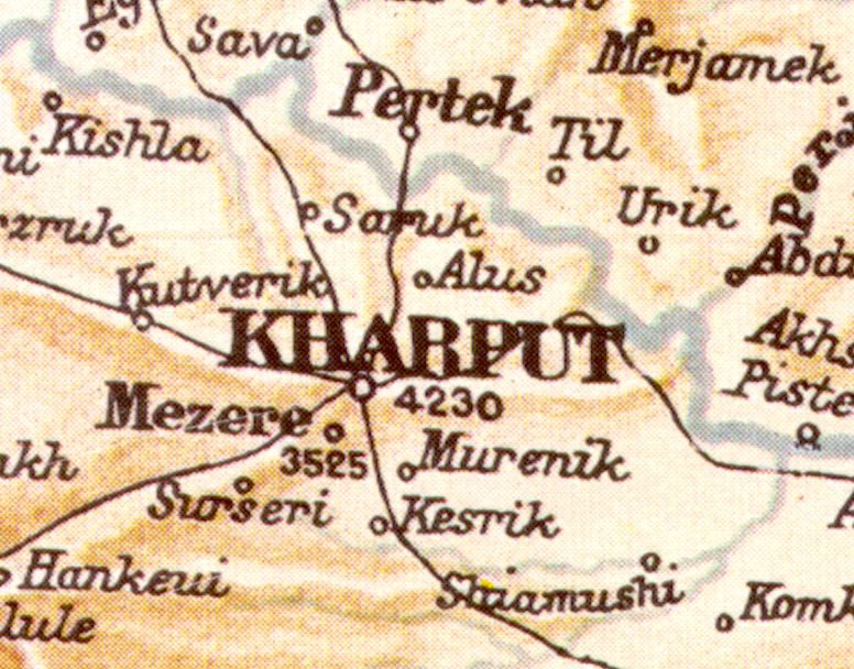
Kharpert, also called Kharberd, Kharput, Kharpoot, Harpert,
Harpoot, Harput, Harpout, Harpouth, Elazig, Elaziz, Mamuret el Aziz, Mamuret-ul-Aziz,
Mamurelulaziz, refers to any of the following geographical areas:
(1) geographical plain of Kharpert,
(3) Kharpert valley
(2) vilayet (province) of Kharpert,
(3) sanjak of Kharpert, and
(4) ancient city of Kharpert
Plain of Kharpert
The ancient city of Kharpert was located on what was known as
"the plain of Kharpert." The plain of Kharpert, with an altitude of over
3,000 feet, marks the western boundary of a series of plateaus in the Armenian highlands.
Throughout the highlands, there is a marked contrast between the plateaus and the
peripheral mountains (Lynch Vol. 2, 390).
According to Lynch, "a fairly level country extends from
the territory of Kharpert eastwards to the confines of Palu. The Murad River wanders
in many channels over the expanse, approached at an interval which is always diminishing
by the Tauric barrier." (Lynch Vol. 2, 390)
Kharpert Vilayet & Sanjak
During the Ottoman rule of historical Armenia, there were six
provinces (vilayets, eyalet) in historical Armenia: Erzurum, Bitlis, Van, Diyarbekir,
Sivas and Kharpert (Mamuret ul-Aziz) (Shaw 201). The area was traditionally
referred to as the "Six Vilayets" or the "Six Provinces" in Ottoman
Anatolia. (Lynch Vol. 2, 413)
According to Lynch, about the year 1890, the vilayet
(province) of Kharpert included two sanjaks: Sanjak Kharpert (with 85,000 Armenians and a
total population of 206,756) and the Sanjak Dersim (with 8,000 Armenians and a total
population of 70,000). The Vilayet Kharput had a total population of 276,756,
including 93,000 Armenians; 182,000 Moslems; 1,334 Greeks; and 422 others (Lynch Vol.
2, 412-413). Lynch noted, "The figures for the Kharput sanjak are an
estimate made for me by Consul Boyajean of Diarbekr, at the instance of Consul R. W.
Graves. I had previously calculated that the Christians were in a majority in that
sanjak" (Lynch Vol. 2, 413).
When discussing the Armenian population, Lynch later said that
since the statement about the 1890 population, the number of Armenians have been reduced
by the massacres of 1895. He stated that 500 Armenians in Kharput were
"butchered." He continued, "Reliable figures are wanting for the
losses in human life throughout the country districts of the vilayets of Van, Bitlis and
Kharput. But they must have been considerable and whole villages were wiped
out." (Lynch Vol. 2, 412)
According to George
Mouradian, In 1912, there were 168,000 Armenians in the province of Kharput. Because
of the massacres and deportations of World War I, today there are very few Armenians left
in later years. (Mouradian 104)"
According to the Armenian
patriarchal statistics, in 1912, there were 2,100,000 Armenians in the Ottoman Empire, and
a total of 1,018,000 Armenians in the six provinces of Turkish Armenia (Hovannisian
234-235).
Armenians Population
in Six Provinces of Turkish Armenia
Source: Armenian Patriarchate, 1912 |
Erzerum |
215,000 |
Van |
185,000
|
Bitlis |
180,000 |
Kharput |
168,000 |
Sivas |
165,000 |
Diarbekir |
105,000 |
| Total |
1,018,000
|
Kharpert City
 The ancient city
of Kharpert (Harput) was located in the sanjak of Kharpert, vilayet of Kharput, and
on the plain of Kharpert during the Ottoman rule of historical Armenia. Kharput had a
long, eventful history, and its significance effectively ended in the 19th and 20th
centuries with the Armenian massacres, a series of earthquakes, and the building of
Elazig. The ancient city
of Kharpert (Harput) was located in the sanjak of Kharpert, vilayet of Kharput, and
on the plain of Kharpert during the Ottoman rule of historical Armenia. Kharput had a
long, eventful history, and its significance effectively ended in the 19th and 20th
centuries with the Armenian massacres, a series of earthquakes, and the building of
Elazig.
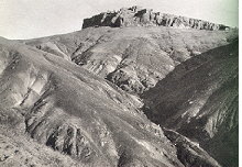
 Guarded by its photogenic castle, Kharput was an important
way-station on the Silk Road to and from China and India (Brosnahan 655). Guarded by its photogenic castle, Kharput was an important
way-station on the Silk Road to and from China and India (Brosnahan 655).
Between 1893 to 1898, H. F. B. Lynch undertook two separate
journeys in Armenia. In Lynch's book, Armenia Travel and Studies, he refers
to the city of Kharpert and says,
The town is built on a hill, not far south of the Murad, on
the northern confines of the plain; and the old castle overlooks the expanse at a
difference in level of about 1,000 feet.
Various estimates assign a population of from 13,000 to 25,000
souls to this ancient Armenian borough; and although the Armenians are in great minority
in the city, they have a large preponderance among the inhabitants of the surrounding
region. It has been estimated that not less than 130 to 150 villages are situated in
this vicinity.
The vine flourishes and is cultivated at this moderate
elevation; and the dwellings are for the most part constructed of mud and brick with two
storeys, in striking contrast to the unhealthy underground burrows in which the peasantry
cheat the rigour of an Armenian winter over the greater portion of the area of the
tableland. Pear and plum trees grace the outskirts of the settlements, and the
mulberry grows in such profusion that the silk crop is often of considerable value.
Kharpert has become a centre of American missionary effort--on
the whole a salutary and civilising influence in these lands. Their educational
activities are represented by a well-equipped institution founded in 1876 and bearing the
name of Armenia College. Thither flock the Armenian youth from all parts of the
country, to grow up beneath the example of the most progressive of Western peoples.
Within recent years the value of that example has somewhat diminished in their eyes, owing
to the impunity with which the organisers of Palace policy in Constantinople have applied
the torch to the property of American citizens and the ban of the censor to the loftiest
creations of Western literature. (Lynch Vol. 2, 390-391)
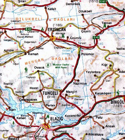
Today, the ancient Kharput
(Harput), 1,280m (4,200 feet) above sea level, is 6 kilometers (3.7 miles) to the
northeast of the modern-day city of Elazig (Brosnahan 655). Diana Drake,
the author of her 1997 publication, Exploring Turkey, describes Kharput (Harput)
as "now almost derelict." She continues to say, "Just 100 years ago
Harput had 800 shops, 10 mosques, 10 religious schools, 8 churches, 8 libraries, 12 hans
(inns), and 90 baths, but its population moved down to Elazig when the new town was built,
prompted partly by earthquakes in the region" (Drake 225).
In 1998, the Poochigian group visited Elazig and then
Kharpert, where the Armenian church is built partially underground in the mountain.
John Poochigian commented, "We climbed through a hole, about the size of a
refrigerator, that led into the church." John continued, "Kharpert
College, which was located on the side of a Mountain, no longer exists. The College
was replaced with housing and apartments."
Modern-day attractions in the
ancient city of Kharpert include the remains of an Armenian church, the Church of the
Virgin Mary (Meryem Ana Kilisesi), the Byzantine Fortress, and the Arap Baba Turbesi, a
Seljuk work (Brosnahan 656). Several mosques of the Seljuk period remain (Focus
Multimedia, Eastern Anatolia).
As a result of the Genocide, Kharpert's Armenian population
was either massacred or they fled their homeland for refuge in other locations in the
world. In the 19th century, the city of Kharpert also suffered destruction from
several earthquakes. Following the Genocide and the earthquakes, what was left of of
Kharpert's remaining population deserted the ancient city and relocated in the newly
constructed city of Elazig.
Elazig City
 After the establishment of the Turkish Republic in
1923, the city of Elazig replaced "Harput," which for many centuries was the
principal town in the region. (McDonagh 551) After the establishment of the Turkish Republic in
1923, the city of Elazig replaced "Harput," which for many centuries was the
principal town in the region. (McDonagh 551)
"The old city of
Kharpert is now Elazig," says Dr. John Poochigian, Jr., who visited Kharpert and
Elazig in 1998. "Today, what they refer to as "Harput" is an area on
the top of a mountain, which is surrounded by the city of Elazig," continues Dr.
Poochigian. (John Poochigian, Jr.)
Elazig (EHL-lah-zuh, population 200,000, is a new town, only founded in
the 19th century at a place called Mezraa. Elazig, located in the upper Euphrates (Firat) region, is a Eastern
Anatolian city and province. It's altitude is 1067 meters above sea level and is
located at Longitude: 39°14' E and Latitude: 38°41' N (Elazig).
The provincial capital of Elazig was founded by Sultan Abdul
Aziz and named Mamuret el-Aziz or Alaziz. This was changed to Elazig after the
establishment of the Turkish Republic (McDonagh 551). Elazig is also called
Elaziz, Elazid, Elazığ, Alaziz, Mamuret el-Aziz, Mamuret-ul-Aziz and Mamurelulaziz.
The modern-day city of Elazig "lies on a plain in the
shadow of a mountain crowned with the ancient city of Kharpert's citadel, an important
Seljuk and Ottoman cultural and academic center" (Republic of Turkey, Eastern Anatolia).
Today, Elazig is a farming center and university town with its
Euphrates University (Firat
Universitesi). Elazig's importance as an entrepot (a commercial center where
goods are received for distribution and trans-shipment) ended when the Keban Lake (See The Keban Dam) cut it off from main roads to the north and east (Brosnahan 654).
Viticulture, the cultivation of grape vines and grape-growing
is important in the region around Elazig (Broshahan 654). Elazig is
surrounded by vineyards and gardens. Tekel, the government spirits company, raises
vineyards around Elazig to produce the dark red grapes called okuzgozu (ox-eye),
from which Buzbag wine is made, and the long white kecik memesi (goat teat)
grapes (Broshahan 654 & McDonagh 551).
The town of Elazig has a large number of pastahanler,
pastry shops, which are filled with cakes and pastries (McDonagh 551).
Today, attractions around
Elazig include Lake Hazar, 16 miles (25 kilometers) south of Elazig. The Buzluk Cave, 7 miles
(12 kilometers) northeast, remains cool in the summers and warm
in the winters (Republic of Turkey, Eastern Anatolia).
North of Elazig, the fortress
of Pertek, built in the Middle Ages, is still in good condition today. High
mountains encircle Tunceli, 83 miles (133 kilometers) north of Elazig. In the Munzur
Valley National Park near Ovacìk, 37 miles (60 kilometers) northwest of Tunceli, there is amazing scenery
and trout-filled streams fishing streams according to Focus Multimedia.. (Focus Multimedia)
Continental climate prevails in the city of Elazig and
surrounding area. Characteristics of continental are hot and dry summers,and cold
and harsh winter (Ameritech). For today's Weather Conditions and Forecast for Elazig, Turkey, see
Infoseek' s Weather Outlook.
The Keban & Karakaya Dams
The city of Elazig is surrounded by Keban and Karakaya dams
and Lake Hazar (Elazig). The hydroelectric generator capacity in thousands of megawatts for the
Karakaya Dam on the Western Euphrates (Firat) is 7,354 and the Keban Dam on the
Western Euphrates (Firat) is 5,800 (Ameritech).
In the 1960's, the creation of the Keban Dam (Keban Baraji),
north-west of Elazig, caused the flooding of the valleys to the north (Brosnahan 655).
The Keban and Karakaya
Dams on the Firat River (Western Euphrates) have created huge artificial lakes, which have
altered the surrounding environment and contributed to the growth and general appearance
of this rapidly developing city. The city of Elazig resembles a peninsula. These
artificial and natural lakes have a considerable effect on the climate of the city.
Before the new lake was
created by the Keban Dam, an archaeological rescue project excavated many likely sites.
According to Diana Drake, the author of Exploring Turkey,
The Keban Dam was the first of a series of dams to be built on
the River Euphrates, designed to bring electricity and irrigation to neglected parts of
the country. With its construction, however, 50 known archaeological sites were flooded,
most of them early Bronze Age settlements that might have contributed important evidence
about man's first settled existence in Anatolia after he had stopped his nomadic wandering
and hunting. Five foreign archaeological teams, all self-financed, excavated as many of
these sites as possible before the flooding in 1974. (Drake 225)
The artifacts uncovered are
in Elazig's Archaeological and Ethnographic Museum (Elazig Arkeoloji ve Ethnografya
Muzesi) on the campus of Euphrates University (Firat Universitesi) (Brosnahan
655). The museum has
a collection of objects found in rescue digs made between 1968 and 1974 at sites to be
flooded by the Keban Dam project. Objects include ivories, jewelry and gold
ornaments. The museum also has a large collection of pottery, statuettes, stelae,
mirrors, bronze objects, marble statues and architectural fragments and coins from the
prehistoric era to the Byzantine period. The ethnographic material includes
embroidery, kilims, carpets, household utensils and female dresses and ornaments from the
surrounding area. (McDonagh 551)
Go to:
Part 4 - The Armenians
&
The Armenian Language
Last Updated 07/09/99 |