|
| | Version 2.2.78 got updated
on August 11, 2003 Download from here...
A filter option is added, to remove points that are close to
each other or points that are in line.
A method for using GaRoute while having FontMachine is
implemented. Mail me for more information
on this.
GaRoute will integrate with RealMaps
by Kevin Millican. Both reading points and reading/writing waypoint (.TXT)
files.
Also I added navigation buttons on the main screen to quickly
move to Realmaps, Route and Street. You can also switch by
just typing "R", "S", "C", "P" or
"E"

Use 2.2.65 if you are using TomTom Citymaps 3.0 or
TomTom Route 3.0. It solves problems with the new instruction table, where
instructions occupy multiple lines. Especially on the Revo, this was
problematic.
New in GaRoute Version 2.2
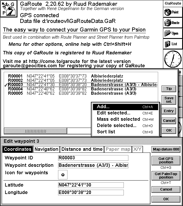
 | Select a point in RealMaps and store in in Garoute for further uploading
to your GPS as route or waypoint. |
 | You can automate the process and quickly capture series of points and
Garoute will then assign names automatically. |

 | The list screen allows mass editing and bulk-deletion of selectable
points. |

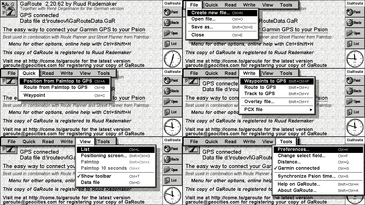
 | The menu looks like this now: |

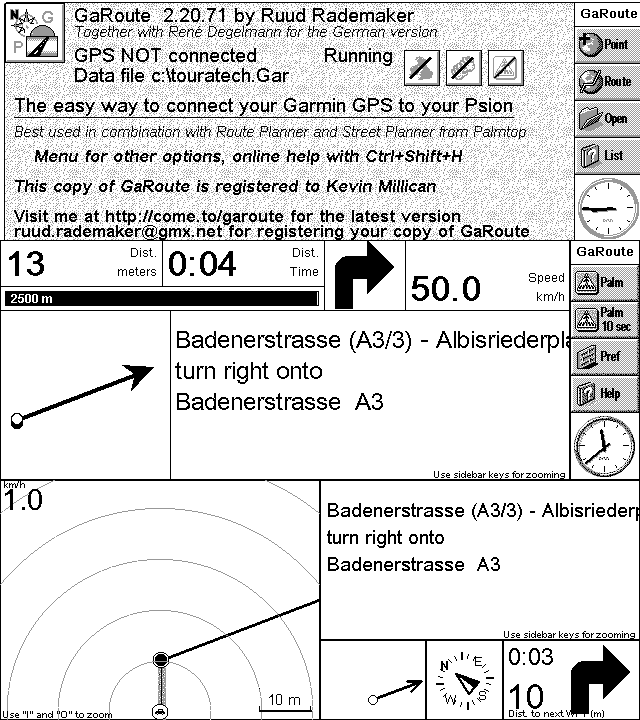
 | Navigation screeshots (no Route/Street screenshot added, as the swapping
function would show) |

 | Fix problem when no d-drive is there, for street info.
Fix problem instruction screen (NMEA arrow does not refresh)
Fix problem French language route interpretation
Fix problem route interpretation, now an error message is shown if the user has not configured time columns
Fixed problem reading routes in Route Planner 1.4, introduced in 2.2.20
(Millennium version was OK) |
 | Fixed problem in distribution (streeticon.txt & routeicon.txt were
missing) |
 |  NMEA based MAP switching is there....
 |
 | GaRoute can determine whether it is in reach of a Street Planner map.
If so it will switch to the proper map and display
Street Planner. If not within the reach of a Street Planner
map it will switch to Route Planner.
For this feature to work, you will need to configure Garoute
so that it knows about the reach of each Street map.
Garoute features a setup wizard to enter these coordinates. |
 |  Revo Open file dialog fixed, now capturing waypoints & Routes
should work, though the screen resolution is not optimized. |
 | Added TRACK and WAYPOINT altitude reading, for those GPS-es that support it. |
 |  GaRoute will display an heads up graphical map.
 |
 |  GaRoute will display the instruction from Street / Route GaRoute will display the instruction from Street / Route
planner. |
 | Can zoom automatically, so you always see the next
waypoint ahead. |
 |  Can beep when approaching a waypoint Can beep when approaching a waypoint |
 |  This version supports
PCX reading of track/route and waypoints This version supports
PCX reading of track/route and waypoints
as well as writing them. This opens a large number of other
packages to exchange data with. Fugawi, Mapsource and many more. |
Version 2.1.86 is available as of August 28, 2000
I've been making a massive amount of changes....
support for eMap, eTrex, GPS III+, like it's
meant to be and the StreetPilot is in!
Believe me, it's massive, because now I'm supporting all these different
protocols and try to stick with the original datafile.
This is
This version is published as shareware.
Registration fee is 25 US Dollars
If you choose to pay through a secure server by Credit Card, 25+3 US Dollars, see
below.
You can also register as a user online, click here to connect to a
secure site -or- here if your
browser does not support secure connections. Let me
know if you have trouble getting through.
I will process your request and send you an GaRoute 2.1 license by email. I need
your Psion Machine ID for cutting a license. This license can be requested through the
downloaded copy of GaRoute. Just install GaRoute and type control-r, control-r. This will
give you a dialog from which you can fill in your address information and preferred
name.
GaRoute will prepare a license request file, which should be mailed to me. This is the
easiest way for me to process your license requests. See the online GaRoute Help, or drop
me an email if it's not clear.
New in GaRoute Version 2.1.86
 | Fixed distribution problem in .sis file |
New in GaRoute Version 2.1.85
 | Made it Street Planner '99 Millenium compatibel |
New in GaRoute Version 2.1.81
 | COOL added speed, time & dist to trackdata
now you can see how fast you went, where and at what time.
|
 | enhance closing handling for help file, when exiting GaRoute
this caused on error CMDE: not found - whehn closing Garoute
|
 | enhance error handling for connection problems (in NMEA mode or not
cable)
There is now a clear message when Garoute seen NMEA data coming in
|
 | when you find no points in a route, GaRoute tries to open with all
points.
This solves the problem for a downloaded route, where a message was displayed:
"cannot find enough points".
|
 | when files called a* exist GaRoute temporarily renames
them. This fixes
problem importing data into the .GaR file.
|
 | fixed problem in protocol implementation, that could omit trackdata.
If four $10 messages existed in the data coming from the GPS, the message was
misinterpreted and the transfer inappropriately aborted.
|
New in GaRoute Version 2.1.80
 | Added selection of (small) icons for overlay files |
 | Added map datum support, specifically for Dutch Street planner
maps. There was an error in Palmtop's map, that can be compensated for now. |
 | The default i s now _always_ set to Garmin product
capabilities protocol. |
 | Fixed a problem where protocol D401 (proximity waypoints) was reported
as unknown. |
 | Added further NMEA code, is activated by create a file calle useNMEA in
the GaRoute dir. There are still bugs in this area though. (see who reads
this line :-) |
 | Fixed some problems for the Street Pilot |
 | Increased timeout values for GPS communication |
 | Allowed offets (in seconds) for time synchronization |
 | Added support for eMap with 50 routes of 50 points |
New in GaRoute Version 2.1.61
 | This version supports the Garmin
Capabilities Protocol. It means that GaRoute will interrogate your
GPS and figure out the type of device and type of protocol flavours it
support. This will allow me to talk to the newer
devices like the eMap etc. |
 | The waypoint transfer for the eMap,
eTrex, StreetPilot is supported (anyone interested in Aviation type
GPS's let me know) |
 | Communication is so reliable, that you can disconnect you
cable while sending data to the GPS, reconnect again and nothing will be
lost. |
 | The dialog have been dramatically been improved, using the
Neuon nMPD OPX. |
 | You can synchronize the Psion time with the GPS time. |
Previous versions could already
 | Read Routes from both Route Planner
( normal and Millennium) and Street Planner |
 | Store these routes as Route or Track in your GPS,
ready for a goto or trackback |
 | Read/Store/Write Waypoints from your GPS |
 | Read/Store/Write Routes from your GPS |
 | Read/Store/Write Tracks from your GPS |
 | Read/Store/Write overlay files for Route & Street
PLanner |
 | Support German and Dutch
user interface |
 | Store information on the Psion in standard DATA application |
 | Allow you to log the Garmin Protocol IO between GPS and Psion |
 | Show progress, as you drive, distance to next turn, travel time, direction, ETA,
ETE, turn to take. |
 | Automatically switch between Street Planner and Route
Planner as you approach and leave the Street Planner the area |
 | Make a soun\d when you approach a turn |
You can  for a
trail license to use GaRoute 2.1 for a
trail license to use GaRoute 2.1
You can also see more
You need to purchase RoutePlanner and/or SteetPlanner yourself.
See The Palmtop web site for more information on StreetPlanner and RoutePlanner
If you have trouble installing, let me know.
|
![]()