 | ||||||
| Articles | Projects | Resume | Cartoons | Windsurfing | Paintings | Album |
Analysis of Soils at Royal Roads University
by Waterose et. al.

Section 2. Field Sampling:
The soil sample site locations are illustrated on Figure 1: Map of Soil Sample Locations. Three soils samples were collected on January 23, 1998.
2.1 Sample 1. Gravel Pit Soil Sample:
2.2 Sample 2. Lower Field Soil Sample:
2.3 Sample 3. Road Soil Sample:
2.1 Sample 1. Gravel Pit Soil Sample:
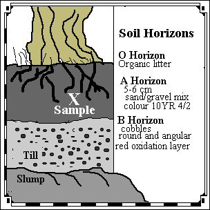
Sample 1 was obtained near the gravel pit near the north-west boundary of RRU. The quarried gravel pit area was approximately 10 metres deep with a diameter of approximately 25 metres. The sample was obtained just south of the gravel pit from an undercut bank dominated by second growth Douglas-fir forest. The undercut bank was 4 metres high with a west slope aspect. An accumulation of materials from the top of the bank had slumped to the base of the bank.At the top of the bank there was a large Douglas-fir with an extensive network of roots that protruded below the litter horizon and outward from the face of the concave slope. The face of the slope was cleaned with a shovel and trowel.
The profile of the soil horizon is illustrated below in Figure 3.

The O horizon of organic material was composed of leaf litter, coniferous needles, mosses and small herbaceous plants less than 2 cm tall. The A horizon was 5 to 7 cm thick. The lower portion blended into the B horizon with no distinct delineation. The B horizon was comprised of rounded and angular cobbles, 2 to 5 cm diameter, in a coarse sand matrix. There was a distinct reddish layer characteristic of oxidation processes. The C horizon was not distinguishable. The lower portion of the slope face was not visible due to slumping of the materials from the upper portion of the slope face.
The sample was obtained one metre below the surface of the O horizon. The soil sample was a dark grey-brown. The Munsell soil colour of the sample was 10YR 4/2 (Munsell, 1994). The sample was a sand and gravel mixture with angular and rounded cobbles in the sand matrix. Approximately 1 litre of the sample was collected into a plastic bag and labelled "Soil Sample 1" and returned to the laboratory for analysis.
2.2 Sample 2. Lower Field Soil Sample:
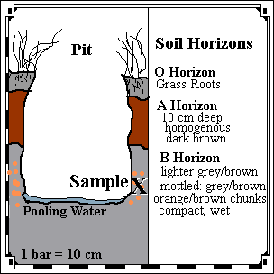
Sample 2 was obtained in the lower field near the Esquimalt Lagoon at the south-west boundary of RRU. The grassy field was approximately 25 by 25 metres. There was a large stand of alder trees at north edge of the field. The field was hummocky and uneven; it has been used in the past as cow pasture land. The dominant vegetation in the field was herbaceous grasses with 5 percent cover of Scotch Broom which is an exotic species. The sample was obtained in the north-west corner of the field. The slope gradient was approximately 7 degrees with a south aspect. The grassy field was very waterlogged.The sampling site was randomly selected and the upper turf layer was removed and put aside. A small pit, 50 cm wide by 70 cm deep, was dug with a shovel until the water pooled at the bottom of the pit. The sample face was cleaned with a small trowel.
The profile of the soil horizon is illustrated below in Figure 4.

The O horizon of organic material was composed of herbaceous grasses and the grass roots extended into the A horizon. The A horizon was 10 cm thick. It was a rich dark brown, loamy and homogenous. There was one earthworm in the A horizon. The lower portion leached downwards into the B horizon. The upper portion of the B horizon was comprised of a lighter grey-brown fine sand matrix. The lower portion of the B horizon had a fine wet compact matrix with coarse mottles of grey and orange brown clay-like materials. The bottom of the pit was covered by murky pooling water.
The sample was obtained 70 cm below the surface of the O horizon. The soil sample was from the section of mottled materials in the lower B horizon. The grey and orange brown colour approximates the Munsell soil colour 7.5YR 5/4 (Munsell, 1994). The sample was a compact clay matrix. Approximately 1 litre of the sample was collected into a plastic bag and labelled "Soil Sample 2" and returned to the laboratory for analysis.
2.3 Sample 3. Road Soil Sample:
Sample 3 was obtained at the roadside just north of the pool complex. The roadside had a partially exposed bank that was dominated by second growth Douglas-fir forest. There were small herbaceous plants and grasses mixed with coniferous needles. The sloped bank was 3 metres high with a south slope aspect and a gradient of 15 degrees. An accumulation of materials from the top of the bank had slumped to the base of the bank. There was a large pile of pieces of black top 2 metres from the sampling site.The O horizon had small rounded pebbles, and organic leaf litter and coniferous needles. The A horizon was a dark brown sandy material. The B horizon was a orange brown fine grained sand. There was evidence of oxidation of minerals in a reddish brown layer. The C horizon was not visible due to the slumped materials at the base of the cliff. The face of the slope was cleaned with a shovel and trowel to obtain the sample. A partial pit was dug in the side of the slope to a depth of 20 centimetres. Approximately 1 litre of the sample was collected into a plastic bag and labelled "Middle Sample" and returned to the laboratory for analysis of permeability.
To Section 3. Laboratory Analysis:
Index:
- Introduction:
- Field Sampling:
- Laboratory Analysis:
- Soil Classification:
- References:
- Postscript:
- Tables and Figures

 email Waterose
Please Sign My Guestbook
Please View My Guestbook

| Articles | Projects | Resume | Cartoons | Windsurfing | Paintings | Album |
 | ||||||